

Geological Survey of Denmark and Greenland Bulletin 26 ... - Geus
Geological Survey of Denmark and Greenland Bulletin 26 ... - Geus
Geological Survey of Denmark and Greenland Bulletin 26 ... - Geus

Create successful ePaper yourself
Turn your PDF publications into a flip-book with our unique Google optimized e-Paper software.
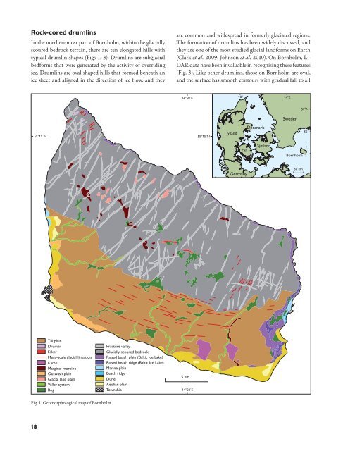
Rock-cored drumlins<br />
In the northernmost part <strong>of</strong> Bornholm, within the glacially<br />
scoured bedrock terrain, there are ten elongated hills with<br />
typical drumlin shapes (Figs 1, 3). Drumlins are subglacial<br />
bedforms that were generated by the activity <strong>of</strong> overriding<br />
ice. Drumlins are oval-shaped hills that formed beneath an<br />
ice sheet <strong>and</strong> aligned in the direction <strong>of</strong> ice flow, <strong>and</strong> they<br />
are common <strong>and</strong> widespread in formerly glaciated regions.<br />
The formation <strong>of</strong> drumlins has been widely discussed, <strong>and</strong><br />
they are one <strong>of</strong> the most studied glacial l<strong>and</strong>forms on Earth<br />
(Clark et al. 2009; Johnson et al. 2010). On Bornholm, Li-<br />
DAR data have been invaluable in recognising these features<br />
(Fig. 3). Like other drumlins, those on Bornholm are oval,<br />
<strong>and</strong> the surface has smooth contours with gradual fall to all<br />
14°58´E<br />
10° 14°E<br />
57°N<br />
Sweden<br />
55°15´N<br />
55°15´N<br />
Jyll<strong>and</strong><br />
<strong>Denmark</strong><br />
56°<br />
Fyn<br />
Sjæll<strong>and</strong><br />
Bornholm<br />
Germany<br />
50 km<br />
Till plain<br />
Drumlin<br />
Esker<br />
Mega-scale glacial lineation<br />
Kame<br />
Marginal moraine<br />
Outwash plain<br />
Glacial lake plain<br />
Valley system<br />
Bog<br />
Fracture valley<br />
Glacially scoured bedrock<br />
Raised beach plain (Baltic Ice Lake)<br />
Raised beach ridge (Baltic Ice Lake)<br />
Marine plain<br />
Beach ridge<br />
Dune<br />
Aeolian plain<br />
Township<br />
5 km<br />
14°58´E<br />
Fig. 1. Geomorphological map <strong>of</strong> Bornholm.<br />
18


