

Geological Survey of Denmark and Greenland Bulletin 26 ... - Geus
Geological Survey of Denmark and Greenland Bulletin 26 ... - Geus
Geological Survey of Denmark and Greenland Bulletin 26 ... - Geus

Create successful ePaper yourself
Turn your PDF publications into a flip-book with our unique Google optimized e-Paper software.
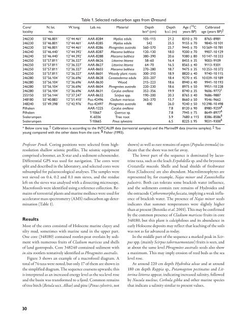
Table 1. Selected radiocarbon ages from Øresund<br />
Core/ N. lat. W. long. Lab. no. Material Depth Depth Age ( 14C Calibrated<br />
locality no. bct* (cm) b.s.l. (m) years BP) age (years BP) †<br />
246230 55°46.801´ 12°44.461´ AAR-8284 Mytilus edulis 105–115 21.2 8310 ± 70<br />
246230 55°46.801´ 12°44.461´ AAR-8285 Mytilus edulis 542 25.5 9155 ± 70<br />
246230 55°46.801´ 12°44.461´ AAR-8286 Phragmites australis 560–570 25.7 9445 ± 70<br />
246240 55°46.440´ 12°44.392´ AAR-8287 Macoma balthica 120–130 18.0 9200 ± 70<br />
246240 55°46.440´ 12°44.392´ AAR-8288 Macoma balthica 380–390 20.6 9380 ± 80<br />
246250 55°57.811´ 12°36.327´ AAR-86<strong>26</strong> Littorina littorea 58–60 16.4 8455 ± 35<br />
246250 55°57.811´ 12°36.327´ AAR-8627 Littorina littorea 64–70 16.5 8565 ± 40<br />
246250 55°57.811´ 12°36.327´ AAR-8603 Macoma balthica 270–280 18.7 9475 ± 35<br />
246250 55°57.811´ 12°36.327´ AAR-8601 Woody plant roots 300–310 18.9 8820 ± 40<br />
246280 55°56.104´ 12°36.696´ AAR-8628 Cerastoderma edulis 203–207 18.4 9270 ± 45<br />
246280 55°56.104´ 12°36.696´ AAR-8630 Wood 215–223 18.6 8940 ± 40<br />
246280 55°56.104´ 12°36.696´ AAR-8604 Phragmites australis 220–230 18.6 8975 ± 50<br />
246280 55°56.104´ 12°36.696´ AAR-8631 Corylus avellana 352–356 19.9 8740 ± 35<br />
255150 55°56.144´ 12°37.247´ AAR-8632 Scirpus spp. 190–200 20.3 8765 ± 40<br />
348180 55°40.883´ 12°51.410´ Poz-42496 Cladium mariscus 365–370 15.7 8660 ± 50<br />
348240 55°49.398´ 12°42.976´ Poz-42497 Phragmites australis 400 <strong>26</strong>.0 9240 ± 50<br />
Pilhaken AAR-1225 Corylus avellana 7.8 8120 ± 90<br />
Pilhaken T-10667 Quercus sp. 7.8 7945 ± 75<br />
Svalerumpen K-6036 Tree root 5.9 7680 ± 115<br />
Svalerumpen T-10665 Pinus sylvestris 6.5 8225 ± 95<br />
8765–8981<br />
9840–10 101<br />
10 569–10 781<br />
9907–10 129<br />
10 147–10 333<br />
9003–9109<br />
9113–9301<br />
10 253–10 372<br />
9740–10 115<br />
10 039–10 189<br />
9941–10 193<br />
9951–10 228<br />
9606–9772 ‡<br />
9686–9887<br />
9546–9662<br />
10 298–10 498<br />
8980–9259 $<br />
8649–8977 $<br />
8386–8586 $<br />
9031–9300 $<br />
* Below core top. † Calibration is according to the INTCAL09 data (terrestrial samples) <strong>and</strong> the Marine09 data (marine samples). ‡ Too<br />
young compared with the other dates from the core. $ Fisher (1993).<br />
Pr<strong>of</strong>essor Penck. Coring positions were selected from highresolution<br />
shallow seismic pr<strong>of</strong>iles. The seismic equipment<br />
comprised a boomer, an X-star <strong>and</strong> a sediment echosounder.<br />
Differential GPS was used for navigation. The cores were<br />
split <strong>and</strong> described in the laboratory, <strong>and</strong> selected cores were<br />
subsampled for palaeoecological analyses. The samples were<br />
wet sieved on 0.4, 0.2 <strong>and</strong> 0.1 mm sieves, <strong>and</strong> the residue<br />
left on the sieves was analysed with a dissecting microscope.<br />
Macr<strong>of</strong>ossils were identified using a reference collection. Remains<br />
<strong>of</strong> terrestrial plants <strong>and</strong> marine molluscs were used for<br />
accelerator mass spectrometry (AMS) radiocarbon age determination<br />
(Table 1).<br />
Results<br />
Most <strong>of</strong> the cores consisted <strong>of</strong> Holocene marine clayey <strong>and</strong><br />
silty mud, sometimes with marine s<strong>and</strong> in the upper part.<br />
One core (348180) contained rootlet-peat overlain by sediment<br />
with numerous fruits <strong>of</strong> Cladium mariscus <strong>and</strong> shells<br />
<strong>of</strong> l<strong>and</strong> gastropods. Core 348240 contained sediment with<br />
in situ rootlets tentatively identified as Phragmites australis.<br />
Figure 3 shows an example <strong>of</strong> a macr<strong>of</strong>ossil diagram. A<br />
total <strong>of</strong> 74 taxa were noted, but only 17 <strong>of</strong> them are shown in<br />
the simplified diagram. The sequence coarsens upwards; this<br />
is interpreted as an increased energy level as the sea level rose<br />
<strong>and</strong> the basin was transformed to a fjord. Common remains<br />
<strong>of</strong> tree birch (Betula sect. Albae) <strong>and</strong> pine (Pinus sylvetris, not<br />
shown) as well as rare remains <strong>of</strong> aspen (Populus tremula) indicate<br />
that the shore was not far away.<br />
The lower part <strong>of</strong> the sequence is dominated by lacustrine<br />
taxa, such as the leach Erpobdella sp. <strong>and</strong> the bryozoan<br />
Cristatella mucedo. Shells <strong>and</strong> head shields <strong>of</strong> freshwater<br />
fleas (Cladocera) are also abundant. Macrolimnophytes are<br />
represented by, for example, Najas minor <strong>and</strong> Zannichellia<br />
palustris. Both can tolerate some brackish water influence,<br />
<strong>and</strong> the sediments contain rare remains <strong>of</strong> Hydroidea <strong>and</strong><br />
the ostracode Cythoromorpha fuscata, implying a weak influence<br />
<strong>of</strong> brackish water. The presence <strong>of</strong> Najas minor seeds<br />
indicates that summer temperatures were slightly higher<br />
than at present (Bennike et al. 2001). This may be confirmed<br />
by the common presence <strong>of</strong> Cladium mariscus fruits in core<br />
348180, but this plant is calciphilous <strong>and</strong> its abundance in<br />
early Holocene deposits may reflect that leaching <strong>of</strong> the soils<br />
was not as far advanced as today.<br />
In the middle part <strong>of</strong> the sequence a marked peak in Scirpus<br />
spp. (mainly Scirpus tabernaemontani) fruits is seen, <strong>and</strong><br />
at about the same level Phragmites australis seeds also show<br />
a maximum. This may imply erosion <strong>of</strong> reed beds as the sea<br />
level rose.<br />
At around 220 cm depth Hydrobia ulvae <strong>and</strong> at around<br />
180 cm depth Ruppia sp., Potamogeton pectinatus <strong>and</strong> Littorina<br />
littorea appear, indicating increased salinity, followed<br />
by Nucula nucleus, Corbula gibba <strong>and</strong> other marine species<br />
that indicate a salinity similar to present values.<br />
30


