

Geological Survey of Denmark and Greenland Bulletin 26 ... - Geus
Geological Survey of Denmark and Greenland Bulletin 26 ... - Geus
Geological Survey of Denmark and Greenland Bulletin 26 ... - Geus

Create successful ePaper yourself
Turn your PDF publications into a flip-book with our unique Google optimized e-Paper software.
Border fault<br />
Footwall uplift<br />
Fig. 3. Model <strong>of</strong> syn-sedimentary infill in a half-graben.<br />
10 km<br />
Fault scarp<br />
Basin<br />
Sediment layers<br />
Rivers<br />
Bottom <strong>of</strong> basin<br />
Fig.4. Map <strong>of</strong> the Bornholm Basin showing the bathymetry <strong>and</strong> deep<br />
faults (black stippled lines). The red arrows show inflow channels.<br />
Edge <strong>of</strong> basin<br />
Depth (m)<br />
100<br />
frequency single beam data (5–100 kHz), echo sounder data<br />
as well as high frequency seismic data. Sediment acoustic<br />
work using a 5–100 kHz signal was mainly carried out in<br />
areas known to be rich in gas at shallow depths in Mecklenburger<br />
Bucht, the Arkona Basin <strong>and</strong> the Bornholm Basin in<br />
the western Baltic. Data from Parasound <strong>and</strong> an Innomar<br />
sediment echo sounder were acquired simultaneously for all<br />
acoustic lines. Extensive seismic data were acquired from the<br />
gas-rich part <strong>of</strong> the Bornholm Basin (Figs 1, 2). The sediment<br />
acoustic records were used to select places for collection<br />
<strong>of</strong> water-column data <strong>and</strong> bottom sediments during the<br />
cruises. The simultaneous recording with different devices<br />
allowed comparison <strong>of</strong> the different responses to the occurrence<br />
<strong>of</strong> gas at shallow depths.<br />
The new seismic field data collected during project Baltic<br />
Gas was loaded onto a seismic work station <strong>and</strong> combined<br />
with seismic archive data from the same area. The seismic<br />
dataset was interpreted <strong>and</strong> combined with physical characteristics<br />
<strong>of</strong> the sediments plus additional seabed data to compile<br />
a map <strong>of</strong> the gas distribution in the Baltic Sea. Multisensor<br />
core logging <strong>of</strong> 6–12 m long gravity cores were used<br />
for estimating the basic physical properties <strong>of</strong> sediments with<br />
<strong>and</strong> without gas bubbles. Split cores were used for core description,<br />
sub-sampling <strong>and</strong> sedimentological analyses.<br />
Gas distribution mapping in the<br />
Bornholm Basin<br />
As stated in the introduction, the main aim <strong>of</strong> the project<br />
was to produce a map <strong>of</strong> the seabed gas distribution in the<br />
SW<br />
NE<br />
Free<br />
gas<br />
Glacial deposits<br />
Littorina Sea mud<br />
Ancylus Lake clay<br />
Yoldia Sea clay<br />
Baltic Ice Lake clay<br />
10 m<br />
Bedrock<br />
5 km<br />
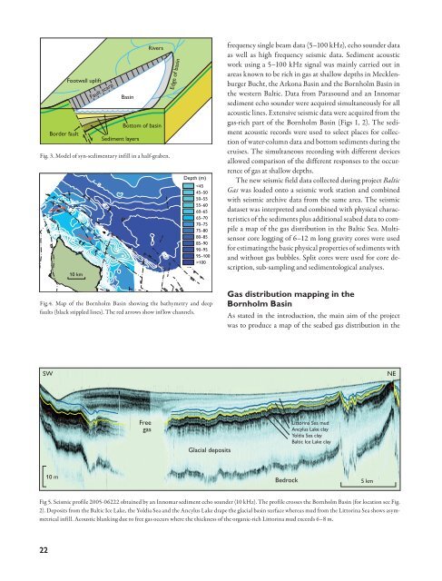
Fig 5. Seismic pr<strong>of</strong>ile 2005-06222 obtained by an Innomar sediment echo sounder (10 kHz). The pr<strong>of</strong>ile crosses the Bornholm Basin (for location see Fig.<br />
2). Deposits from the Baltic Ice Lake, the Yoldia Sea <strong>and</strong> the Ancylus Lake drape the glacial basin surface whereas mud from the Littorina Sea shows asymmetrical<br />
infill. Acoustic blanking due to free gas occurs where the thickness <strong>of</strong> the organic-rich Littorina mud exceeds 6–8 m.<br />
22


