

Desk Study on the Environment in Iraq Desk Study on the ... - UNEP
Desk Study on the Environment in Iraq Desk Study on the ... - UNEP
Desk Study on the Environment in Iraq Desk Study on the ... - UNEP

You also want an ePaper? Increase the reach of your titles
YUMPU automatically turns print PDFs into web optimized ePapers that Google loves.
2<br />
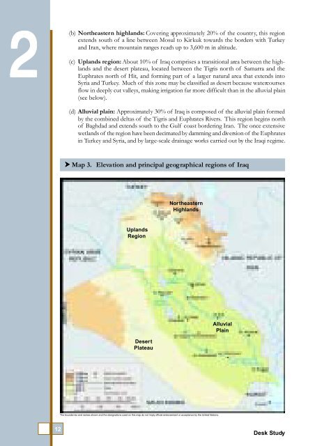
(b)<br />
Nor<strong>the</strong>astern highlands: Cover<strong>in</strong>g approximately 20% of <strong>the</strong> country, this regi<strong>on</strong><br />
extends south of a l<strong>in</strong>e between Mosul to Kirkuk towards <strong>the</strong> borders with Turkey<br />
and Iran, where mounta<strong>in</strong> ranges reach up to 3,600 m <strong>in</strong> altitude.<br />
(c) Uplands regi<strong>on</strong>: About 10% of <strong>Iraq</strong> comprises a transiti<strong>on</strong>al area between <strong>the</strong> highlands<br />
and <strong>the</strong> desert plateau, located between <strong>the</strong> Tigris north of Samarra and <strong>the</strong><br />
Euphrates north of Hit, and form<strong>in</strong>g part of a larger natural area that extends <strong>in</strong>to<br />
Syria and Turkey. Much of this z<strong>on</strong>e may be classified as desert because watercourses<br />
flow <strong>in</strong> deeply cut valleys, mak<strong>in</strong>g irrigati<strong>on</strong> far more difficult than <strong>in</strong> <strong>the</strong> alluvial pla<strong>in</strong><br />
(see below).<br />
(d) Alluvial pla<strong>in</strong>: Approximately 30% of <strong>Iraq</strong> is composed of <strong>the</strong> alluvial pla<strong>in</strong> formed<br />
by <strong>the</strong> comb<strong>in</strong>ed deltas of <strong>the</strong> Tigris and Euphrates Rivers. This regi<strong>on</strong> beg<strong>in</strong>s north<br />
of Baghdad and extends south to <strong>the</strong> Gulf coast border<strong>in</strong>g Iran. The <strong>on</strong>ce extensive<br />
wetlands of <strong>the</strong> regi<strong>on</strong> have been decimated by damm<strong>in</strong>g and diversi<strong>on</strong> of <strong>the</strong> Euphrates<br />
<strong>in</strong> Turkey and Syria, and by large-scale dra<strong>in</strong>age works carried out by <strong>the</strong> <strong>Iraq</strong>i regime.<br />
Map 3. Elevati<strong>on</strong> and pr<strong>in</strong>cipal geographical regi<strong>on</strong>s of <strong>Iraq</strong><br />
Nor<strong>the</strong>astern<br />
Highlands<br />
Uplands<br />
Regi<strong>on</strong><br />
Desert<br />
Plateau<br />
Alluvial<br />
Pla<strong>in</strong><br />
The boundar ies and names shown and <strong>the</strong> designati<strong>on</strong>s used <strong>on</strong> this map do not imply official endorsement or acceptance by <strong>the</strong> United Nati<strong>on</strong>s.<br />
12<br />
<str<strong>on</strong>g>Desk</str<strong>on</strong>g> <str<strong>on</strong>g>Study</str<strong>on</strong>g>


