Policy Framework - Jacksonville Transportation Authority
Policy Framework - Jacksonville Transportation Authority
Policy Framework - Jacksonville Transportation Authority

Create successful ePaper yourself
Turn your PDF publications into a flip-book with our unique Google optimized e-Paper software.
103rd St<br />
Garden St<br />
Crystal Springs Rd<br />
Prichard Rd<br />
Collins Rd<br />
Wilson Blvd<br />
Dunn Ave<br />
Park St<br />
San Juan Blvd<br />
Kingsley Ave<br />
Bowden Rd<br />
Arlington Expy<br />
Zoo Parkway<br />
Old St Augustine Rd<br />
Southside Blvd<br />
Baymeadows Rd<br />
Heckscher Dr<br />
J Turner Butler<br />
Beach Blvd<br />
City of <strong>Jacksonville</strong><br />
<strong>Policy</strong> <strong>Framework</strong> for Transit-Oriented Development<br />
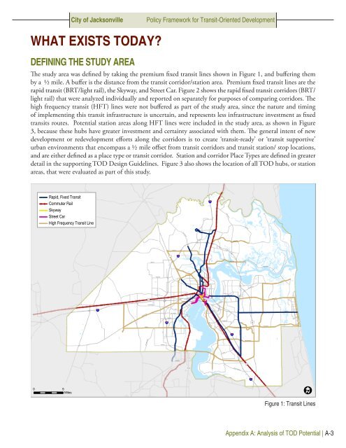
What Exists Today?<br />
Defining the Study Area<br />
The study area was defined by taking the premium fixed transit lines shown in Figure 1, and buffering them<br />
by a ½ mile. A buffer is the distance from the transit corridor/station area. Premium fixed transit lines are the<br />
rapid transit (BRT/light rail), the Skyway, and Street Car. Figure 2 shows the rapid fixed transit corridors (BRT/<br />
light rail) that were analyzed individually and reported on separately for purposes of comparing corridors. The<br />
high frequency transit (HFT) lines were not buffered as part of the study area, since the nature and timing<br />
of implementing this transit infrastructure is uncertain, and represents less infrastructure investment as fixed<br />
transits routes. Potential station areas along HFT lines were included in the study area, as shown in Figure<br />
3, because these hubs have greater investment and certainty associated with them. The general intent of new<br />
development or redevelopment efforts along the corridors is to create ‘transit-ready’ or ‘transit supportive’<br />
urban environments that encompass a ½ mile offset from transit corridors and transit station/ stop locations,<br />
and are either defined as a place type or transit corridor. Station and corridor Place Types are defined in greater<br />
detail in the supporting TOD Design Guidelines. Figure 3 also shows the location of all TOD hubs, or station<br />
areas, that were evaluated as part of this study.<br />
Rapid, Fixed Transit<br />
Commuter Rail<br />
Skyway<br />
Street Car<br />
High Frequency Transit Line<br />
95<br />
Ye low Blu f Rd<br />
Starre t Rd<br />
Lem Turner Rd<br />
New Berlin Rd<br />
9A<br />
1<br />
295<br />
Kings Rd<br />
Monument Rd<br />
Beaver St<br />
90<br />
Atlantic Blvd<br />
Atlantic Blvd<br />
10<br />
Normandy Blvd<br />
17<br />
St Johns River<br />
295<br />
9A<br />
San Jose Blvd<br />
95<br />
Old Middleburg Rd<br />
Hood Rd<br />
1<br />
17<br />
95<br />
0 5<br />
Miles<br />
Figure 1: Transit Lines<br />
Appendix A: Analysis of TOD Potential | A-3