Policy Framework - Jacksonville Transportation Authority
Policy Framework - Jacksonville Transportation Authority
Policy Framework - Jacksonville Transportation Authority

You also want an ePaper? Increase the reach of your titles
YUMPU automatically turns print PDFs into web optimized ePapers that Google loves.
103rd St<br />
Garden St<br />
Crystal Springs Rd<br />
Prichard Rd<br />
Collins Rd<br />
Wilson Blvd<br />
Dunn Ave<br />
Park St<br />
San Juan Blvd<br />
Kingsley Ave<br />
Bowden Rd<br />
Arlington Expy<br />
Zoo Parkway<br />
Old St Augustine Rd<br />
Southside Blvd<br />
Baymeadows Rd<br />
Heckscher Dr<br />
J Turner Butler<br />
Beach Blvd<br />
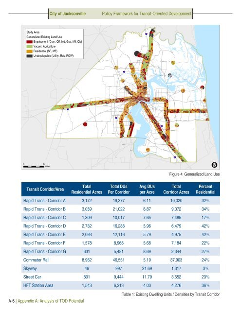
City of <strong>Jacksonville</strong><br />
<strong>Policy</strong> <strong>Framework</strong> for Transit-Oriented Development<br />
Study Area<br />
Generalized Existing Land Use<br />
Employment (Com, Off, Ind, Gov, Mil, Civ)<br />
Vacant; Agriculture<br />
Residential (SF, MF)<br />
Undevelopable (Utility, Rds, ROW)<br />
95<br />
Ye low Blu f Rd<br />
Starre t Rd<br />
Lem Turner Rd<br />
New Berlin Rd<br />
9A<br />
1<br />
295<br />
Kings Rd<br />
Monument Rd<br />
Beaver St<br />
90<br />
Atlantic Blvd<br />
Atlantic Blvd<br />
10<br />
Normandy Blvd<br />
17<br />
St Johns River<br />
295<br />
9A<br />
San Jose Blvd<br />
95<br />
Old Middleburg Rd<br />
Hood Rd<br />
1<br />
17<br />
95<br />
0 5<br />
Miles<br />
Figure 4: Generalized Land Use<br />
Transit Corridor/Area<br />
Total<br />
Residential Acres<br />
Total DUs<br />
Per Corridor<br />
Avg DUs<br />
per Acre<br />
Total<br />
Corridor Acres<br />
Percent<br />
Residential<br />
Rapid Trans - Corridor A 3,172 19,377 6.11 10,020 32%<br />
Rapid Trans - Corridor B 3,059 21,022 6.87 9,072 34%<br />
Rapid Trans - Corridor C 1,309 10,017 7.65 7,485 17%<br />
Rapid Trans - Corridor D 2,732 16,288 5.96 6,479 42%<br />
Rapid Trans - Corridor E 2,093 12,116 5.79 4,975 42%<br />
Rapid Trans - Corridor F 1,578 8,968 5.68 7,184 22%<br />
Rapid Trans - Corridor G 631 5,481 8.69 2,344 27%<br />
Commuter Rail 8,962 46,551 5.19 37,903 24%<br />
Skyway 46 997 21.69 1,317 3%<br />
Street Car 801 9,444 11.79 3,552 23%<br />
HFT Station Area 1,543 6,213 4.03 4,276 36%<br />
A-6 | Appendix A: Analysis of TOD Potential<br />
Table 1: Existing Dwelling Units / Densities by Transit Corridor