Policy Framework - Jacksonville Transportation Authority
Policy Framework - Jacksonville Transportation Authority
Policy Framework - Jacksonville Transportation Authority

Create successful ePaper yourself
Turn your PDF publications into a flip-book with our unique Google optimized e-Paper software.
103rd St<br />
Garden St<br />
Crystal Springs Rd<br />
Prichard Rd<br />
Collins Rd<br />
Wilson Blvd<br />
Dunn Ave<br />
Park St<br />
San Juan Blvd<br />
Kingsley Ave<br />
Bowden Rd<br />
Arlington Expy<br />
Zoo Parkway<br />
Old St Augustine Rd<br />
Southside Blvd<br />
Baymeadows Rd<br />
Heckscher Dr<br />
J Turner Butler<br />
Beach Blvd<br />
City of <strong>Jacksonville</strong><br />
<strong>Policy</strong> <strong>Framework</strong> for Transit-Oriented Development<br />
Creating a Virtual Future – Evaluating TOD Potential<br />
A virtual future was created to test the future buildout potential of different TOD policies. The steps in this<br />
process involved identifying the location of future transit hubs (stations areas), and assigning them one of<br />
eight station area, or one of two corridor TOD place types. A typology map of TOD Place Types is shown in<br />
Figure 6. Station areas were assigned to a half-mile area, or buffer, around each hub. The corridors between the<br />
hubs were either assigned an urban corridor, or a suburban corridor place type based depending on where that<br />
corridor intersected with <strong>Jacksonville</strong>’s 2030 Mobility Plan development area designation (Central Business;<br />
Urban Priority, Suburban Priority, see Figure 3 in the <strong>Policy</strong> <strong>Framework</strong>).<br />
Each TOD place making element has associated with it a density and intensity intention for the policy framework.<br />
The density/intensity values are shown in Table 11. The average dwelling units/acre and employment/acre for<br />
each TOD place type is typically given as a variable range, but for purposes of this buildout an exact figure was<br />
adopted. The place making elements were composed and allocated to study area parcels in GIS using CorPlan<br />
- a land use evaluation and allocation tool.<br />
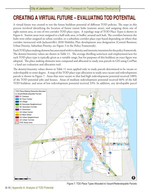
The density/intensity values shown in Table 11 were applied only to study parcels determined to be vacant or<br />
redevelopable to some degree. A map of the TOD place type allocation to study area vacant and redevelopment<br />
parcels is shown in Figure 7. Areas that were vacant or that had high redevelopment potential received 100%<br />
of the TOD potential jobs and houses. Areas of medium redevelopment potential received 66% of the full<br />
TOD buildout, and areas of low redevelopment potential received 33%. In addition, any developable parcel<br />
TOD Place Making Elements Allocated<br />
to Vacant/Redevelopable Parcels<br />
S1 Campus<br />
S2 Town Center<br />
95<br />
S3 Village<br />
Ye low Blu f Rd<br />
S4 Suburban Neighborhood<br />
SC Suburban Corridor<br />
U1 Downtown<br />
Starre t Rd<br />
Lem Turner Rd<br />
U2 Urban Center<br />
U3 Main Street<br />
New Berlin Rd<br />
U4 Urban Neighborhood<br />
UC Urban Corridor<br />
1<br />
295<br />
9A<br />
TOD Study Area<br />
Kings Rd<br />
Monument Rd<br />
Beaver St<br />
90<br />
Atlantic Blvd<br />
Atlantic Blvd<br />
10<br />
Normandy Blvd<br />
17<br />
St Johns River<br />
295<br />
9A<br />
San Jose Blvd<br />
95<br />
Old Middleburg Rd<br />
Hood Rd<br />
1<br />
17<br />
95<br />
0 5<br />
Miles<br />
A-14 | Appendix A: Analysis of TOD Potential<br />
Figure 7: TOD Place Types Allocated to Vacant/Redevelopable Parcels