

CEMP - NZ Transport Agency
CEMP - NZ Transport Agency
CEMP - NZ Transport Agency

Create successful ePaper yourself
Turn your PDF publications into a flip-book with our unique Google optimized e-Paper software.
<strong>NZ</strong> <strong>Transport</strong> <strong>Agency</strong><br />
CSM2 & MSRFL<br />
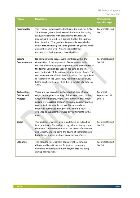
Feature Description AEE technical<br />
specialist report<br />
Groundwater<br />
The regional groundwater depth is in the order of 12 to<br />
20 m below ground level towards Rolleston, becoming<br />
gradually shallower with proximity to the city and<br />
measuring 3 to 5 m below ground level at the Springs<br />
Road junction. The gradient is generally towards the<br />
south east, reflecting the same gradient as ground levels<br />
across the same area. No artesian water was<br />
encountered during project investigations.<br />
Technical Report<br />
No. 11<br />
Ground<br />
Contamination<br />
No contamination issues were identified within the<br />
designation of the alignment. Contaminated soils<br />
outside of the designated alignment were encountered at<br />
the former Southbridge Branch Rail Line and former<br />
gravel pit north of the alignment near Springs Road. The<br />
north east corner of Main South Road and Curraghs Road<br />
is recorded on the Canterbury Regional Council (ECan)<br />
Listed Land Use Register (LLUR) as a landfill site (site no.<br />
3789).<br />
Technical Report<br />
No. 16<br />
Archaeology,<br />
Culture and<br />
Heritage<br />
There are two recorded archaeological sites of Māori<br />
origin in the general vicinity of the Project area, both of<br />
which were middens/ovens. These indicate that Māori<br />
people were passing through this area, possibly on their<br />
way to Banks Peninsula or Lake Ellesmere where<br />
important resources were present. There is little<br />
evidence to suggest there were any settlements in the<br />
area.<br />
Technical<br />
Reports No. 12<br />
and 15<br />
Social<br />
The social assessment area was defined as extending<br />
from southwest Christchurch city, where Hornby is the<br />
dominant commercial centre, to the towns of Rolleston<br />
and Lincoln, and including the towns of Templeton and<br />
Prebbleton. It also considers construction effects.<br />
Technical Report<br />
No. 13<br />
Economic<br />
The economic assessment considers the economic<br />
effects and benefits of the Project on community<br />
economic wellbeing within the Project area including<br />
during construction.<br />
Technical Report<br />
No. 14<br />
Draft 22 <strong>CEMP</strong>


