

Weeks Bay Watershed Project Management Plan - Mobile Bay ...
Weeks Bay Watershed Project Management Plan - Mobile Bay ...
Weeks Bay Watershed Project Management Plan - Mobile Bay ...

Create successful ePaper yourself
Turn your PDF publications into a flip-book with our unique Google optimized e-Paper software.
9<br />
The azonal soils consist of soils that lack distinct genetically related horizons,<br />
generally because of youth, resistant parent material, or steep topography.<br />
These soils are normally well drained to excessively well drained and are<br />
sands and loamy sands. This group makes up 23 percent (28,800 acres) of<br />
the <strong>Watershed</strong> area. The major soils are Lakeland, Eustis, Klej, and<br />
Lakewood.<br />
F. LAND USE AND POPULATION GROWTH<br />
The <strong>Weeks</strong> <strong>Bay</strong> <strong>Watershed</strong> <strong>Project</strong> area encompasses about 149,732 acres in<br />
Baldwin County in southwest Alabama. Parts of the city limits of Fairhope,<br />
Robertsdale, Foley and Loxley are located in the project area. In 1997, town<br />
officials estimated populations to be 12,000, 3,200, 9,400, and 1,600,<br />
respectively. Census results for Baldwin County in 2000 put population<br />
numbers at 140,415, up 43% from the 1990 population of 98,280. The<br />
<strong>Watershed</strong> is primarily rural, but it is within commuting distance from<br />
<strong>Mobile</strong>, Alabama and Pensacola, Florida. Baldwin County is the second<br />
fastest growing county in Alabama behind only Shelby County.<br />
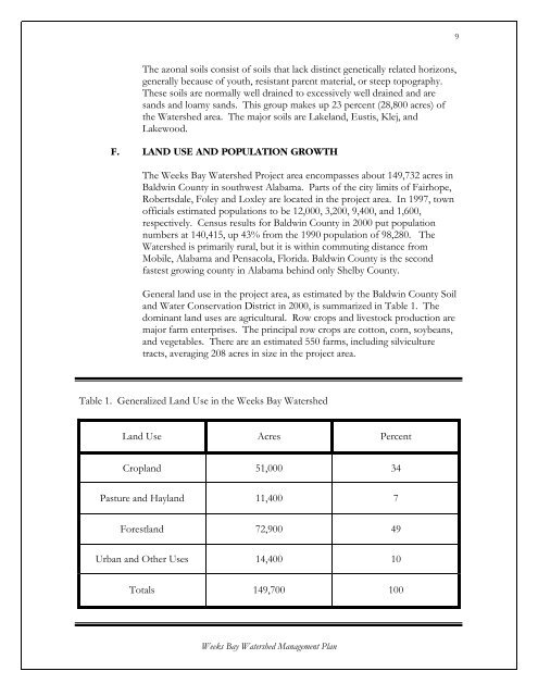
General land use in the project area, as estimated by the Baldwin County Soil<br />
and Water Conservation District in 2000, is summarized in Table 1. The<br />
dominant land uses are agricultural. Row crops and livestock production are<br />
major farm enterprises. The principal row crops are cotton, corn, soybeans,<br />
and vegetables. There are an estimated 550 farms, including silviculture<br />
tracts, averaging 208 acres in size in the project area.<br />
Table 1. Generalized Land Use in the <strong>Weeks</strong> <strong>Bay</strong> <strong>Watershed</strong><br />
Land Use Acres Percent<br />
Cropland 51,000 34<br />
Pasture and Hayland 11,400 7<br />
Forestland 72,900 49<br />
Urban and Other Uses 14,400 10<br />
Totals 149,700 100<br />
<strong>Weeks</strong> <strong>Bay</strong> <strong>Watershed</strong> <strong>Management</strong> <strong>Plan</strong>


