Campus Master Plan (PDF) - Purdue University Calumet
Campus Master Plan (PDF) - Purdue University Calumet
Campus Master Plan (PDF) - Purdue University Calumet

You also want an ePaper? Increase the reach of your titles
YUMPU automatically turns print PDFs into web optimized ePapers that Google loves.
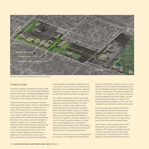
169 STREET<br />
173RD STREET<br />
OAK GROVE<br />
PEREGRINE PATH<br />
FOUNDER’S PLAZA<br />
WOODMAR LAWN<br />
WETLAND<br />
N<br />
EXISTING LANDSCAPE FRAMEWORK AND ICONIC SPACES<br />
<strong>Campus</strong> Image<br />
<strong>Calumet</strong>’s campus is framed by a grove of Oak<br />
trees to the north, the lawns along Woodmar<br />
Avenue to the west, a residential neighborhood<br />
to the east, landscaped right-of-ways along<br />
173rd Street, and a large wetland to the south.<br />
The primary entrance to campus is from the<br />
north along 169th Street, which is a designated<br />
truck route and supports a high volume of<br />
traffic. The <strong>University</strong> has a second entrance<br />
on 173rd street. This entrance is currently<br />
a four-way controlled intersection, allowing<br />
access both to the residential and recreational<br />
facilities in the south, and to the academic<br />
northern section of the campus. Both the<br />
169th and 173rd street entrances feed directly<br />
to large, mostly uninterrupted parking lots.<br />
These parking lots dominate a first-time<br />
visitor’s visual impression of the campus.<br />
Significant improvements would result if<br />
these parking lots were divided into parking<br />
rooms by east-west bands of vegetation and<br />
trees, which would also direct pedestrians<br />
from their cars to nearby buildings, and serve<br />
important ecological functions in terms of<br />
bio-filtration and storm water management.<br />
The campus already has several important<br />
east-west landscape features in the northern<br />
Oak grove and Founder’s Plaza. The Plaza<br />
fronts the student center and contains<br />
native grasses which have been cultivated.<br />
Other important outdoor spaces on campus<br />
include the beautiful lawns along Woodmar<br />
Avenue, and the large wetland holdings to<br />
the south. In general, all these spaces are<br />
close—in fact the entire campus is within<br />
a ten minute walking circle—but they are<br />
disconnected and underutilized. PUC needs to<br />
link these areas via a network of north-south<br />
and east-west landscape improvements.<br />
These kinds of connections are already valued<br />
on campus. The Peregrine Path effectively<br />
links all of the North Academic Core as it runs<br />
indoors from the Anderson Building down to<br />
the Gyte Building, and then outdoors from Gyte<br />
down to Lawshe Hall. This popular pedestrian<br />
corridor is an essential north-south connector,<br />
and an analogous tree-lined outdoor corridor<br />
could become the pedestrian spine of the<br />
campus linking the academic north core with<br />
residential and recreation activity in the south.<br />
Existing landscape configurations also<br />
have important habitat and hydrology<br />
impacts. The Oak grove reduces heat<br />
island effects and, along with Founder’s<br />
Plaza, provides a home to various native<br />
insect, bird and mammal populations.<br />
Storm water runoff is a key issue for PUC<br />
because of its proximity to important<br />
wetlands. The campus currently has large<br />
areas of impervious surfaces (primarily<br />
building roofs and parking lots). North<br />
campus is approximately 48% impervious<br />
16 purdue university calumet master plan report analysis