Royal Rouge Trail Erosion Control Project - Toronto and Region ...
Royal Rouge Trail Erosion Control Project - Toronto and Region ...
Royal Rouge Trail Erosion Control Project - Toronto and Region ...

Create successful ePaper yourself
Turn your PDF publications into a flip-book with our unique Google optimized e-Paper software.
<strong>Project</strong>s (Design Criteria), which seeks to reduce <strong>and</strong> eliminate existing flood, erosion <strong>and</strong><br />
slope instability hazards <strong>and</strong> to rehabilitate valley <strong>and</strong> stream corridors on private <strong>and</strong> public<br />
l<strong>and</strong>s (Appendix A).<br />
1.3 Site Description<br />
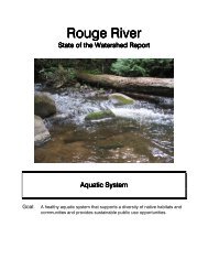
The study area is located in the East Scarborough community of <strong>Rouge</strong>, a suburb located<br />
along the eastern most boundary of the City of <strong>Toronto</strong>. The site is bounded by <strong>Rouge</strong> Park<br />
to the north, residential l<strong>and</strong>s to the east <strong>and</strong> west, <strong>and</strong> a residential road (<strong>Royal</strong> <strong>Rouge</strong> <strong>Trail</strong>)<br />
to the south.<br />
In general, surface water in East Scarborough is directed to drain into the <strong>Rouge</strong> River, which<br />
flows from the north-northwest to the southeast <strong>and</strong> empties into Lake Ontario. In the<br />
immediate vicinity of the study area the <strong>Rouge</strong> River flows generally from east to west in the<br />
valleyl<strong>and</strong>s of the <strong>Rouge</strong> Park, to the north <strong>and</strong> east of <strong>Royal</strong> <strong>Rouge</strong> <strong>Trail</strong>.<br />
The ten single-family residences from Nos. 30 to 48 <strong>Royal</strong> <strong>Rouge</strong> <strong>Trail</strong> back onto the <strong>Rouge</strong><br />
Park, <strong>and</strong> are located at varying distances from the crest of the valley wall. Measurements of<br />
the closest distance from three points on each house, as well as from swimming pools (if<br />
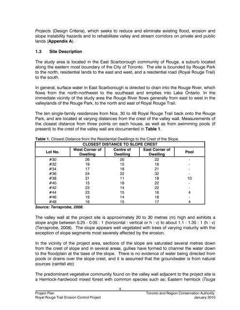
present) to the crest of the valley wall are documented in Table 1.<br />
Table 1. Closest Distance from the Residential Dwellings to the Crest of the Slope.<br />
CLOSEST DISTANCE TO SLOPE CREST<br />
Lot No.<br />
West Corner of Centre of East Corner of<br />
Dwelling Dwelling Dwelling<br />
Pool<br />
#30 26 20 22 -<br />
#32 19 15 16 -<br />
#34 17 18 21 -<br />
#36 24 22 32 -<br />
#38 31 11 18 10<br />
#40 15 18 22 -<br />
#42 23 14 22 -<br />
#44 23 15 16 4<br />
#46 19 14 18 -<br />
#48 16 15 17 4<br />
Source: Terraprobe, 2008.<br />
The valley wall at the project site is approximately 20 to 30 metres (m) high <strong>and</strong> exhibits a<br />
slope angle between 0.25 - 0.05 : 1 (horizontal : vertical or h : v) to about 1.1 - 1.35 : 1 (h : v)<br />
(Terraprobe, 2008). The slope appears well vegetated with trees of varying maturity with the<br />
exception of slope segments most severely affected by the erosion.<br />
In the vicinity of the project area, sections of the slope are saturated several metres down<br />
from the crest of slope <strong>and</strong> in several areas, gullies have formed to channel the water down<br />
to the floodplain at the base of the slope. There is no evidence of water being directed from<br />
pools or drains over the slope crest, <strong>and</strong> it is assumed that the groundwater is from natural<br />
sources (rainfall etc)<br />
The predominant vegetative community found on the valley wall adjacent to the project site is<br />
a Hemlock-hardwood mixed forest with common species such as; Eastern hemlock (Tsuga<br />
4<br />
<strong>Project</strong> Plan<br />
<strong>Toronto</strong> <strong>and</strong> <strong>Region</strong> Conservation Authority<br />
<strong>Royal</strong> <strong>Rouge</strong> <strong>Trail</strong> <strong>Erosion</strong> <strong>Control</strong> <strong>Project</strong> January 2010