Royal Rouge Trail Erosion Control Project - Toronto and Region ...
Royal Rouge Trail Erosion Control Project - Toronto and Region ...
Royal Rouge Trail Erosion Control Project - Toronto and Region ...

Create successful ePaper yourself
Turn your PDF publications into a flip-book with our unique Google optimized e-Paper software.
2. Concept 2 – Extended Retaining Wall <strong>and</strong> Trimming<br />
These options were formally reviewed <strong>and</strong> discussed by the Community Liaison Committee<br />
(CLC) at Meeting #1, held on the evening of June 18 th , 2009 at the Tall Pines Community<br />
Centre located at 64 Ryl<strong>and</strong>er Boulevard in <strong>Toronto</strong>, Ontario. A description <strong>and</strong> evaluation of<br />
the preliminary alternatives follows. The evaluation includes an examination of the types <strong>and</strong><br />
extents of impacts, both positive <strong>and</strong> negative, of each alternative.<br />
4.1.1 “Do Nothing” Alternative<br />
The “do nothing” option is a m<strong>and</strong>atory alternative that must be considered in the Class EA<br />
process, as it is used to justify the need to undertake a remedial flood or erosion control<br />
project. Should the “do nothing” option, or other Conservation Authority programs such as<br />
l<strong>and</strong> acquisition be deemed to be a more acceptable solution, then there is no further<br />
consideration for remedial action <strong>and</strong> the Class EA process terminates.<br />
Under the “do-nothing” alternative recession is expected to continue until the slope reaches a<br />
stable inclination, referred to as the long-term stable slope crest (LTSSC), which would result<br />
in loss of a significant portion of the existing tablel<strong>and</strong>, <strong>and</strong> an additional amount, including<br />
two existing swimming pools, being placed within the erosion hazard limit. In general, the<br />
recession rate was calculated to be approximately 0.18 metres per year. The following table<br />
provides an estimate of the projected length <strong>and</strong> time it will take for each of the properties to<br />
recede to the LTSSC:<br />
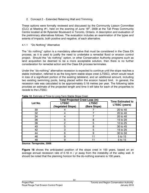
Table 12. Estimate of Time to Long-Term Stable Slope Crest.<br />
Lot No.<br />
Total <strong>Project</strong>ed Crest Loss (m)<br />
Time Estimated to<br />
LTSSC<br />
LTSSC<br />
LTSSC (years)<br />
(Vegetated Slope) (Bare Slope)<br />
30 4 7 20 to 40<br />
32 4 7 20 to 40<br />
34 4 7 20 to 40<br />
36 5 8 15 to 20<br />
38 2 5 10 to 25<br />
40 5 8 30 to 45<br />
42 3 5 15 to 25<br />
44 6 9 30 to 50<br />
46 9 11 5 to 15<br />
48 9 11 5 to 15<br />
Source: Terraprobe, 2008.<br />
Figure 18 shows the anticipated position of the slope crest in 100 years, based on an<br />
average annual recession rate of 0.18 m / yr away from the instability of the valley wall. It<br />
should be noted that the planning horizon for the do-nothing scenario is 100 years.<br />
51<br />
<strong>Project</strong> Plan<br />
<strong>Toronto</strong> <strong>and</strong> <strong>Region</strong> Conservation Authority<br />
<strong>Royal</strong> <strong>Rouge</strong> <strong>Trail</strong> <strong>Erosion</strong> <strong>Control</strong> <strong>Project</strong> January 2010