Royal Rouge Trail Erosion Control Project - Toronto and Region ...
Royal Rouge Trail Erosion Control Project - Toronto and Region ...
Royal Rouge Trail Erosion Control Project - Toronto and Region ...
Create successful ePaper yourself
Turn your PDF publications into a flip-book with our unique Google optimized e-Paper software.
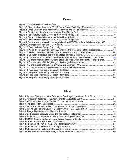
Figures<br />
Figure 1. General location of study area. .................................................................................................. 1<br />
Figure 2. Study limits at the rear of 30 - 48 <strong>Royal</strong> <strong>Rouge</strong> <strong>Trail</strong>, City of <strong>Toronto</strong>........................................ 2<br />
Figure 3. Class Environmental Assessment Planning <strong>and</strong> Design Process. ............................................ 3<br />
Figure 4. <strong>Erosion</strong> scar below Nos. 42 <strong>and</strong> 44 <strong>Royal</strong> <strong>Rouge</strong> <strong>Trail</strong>. ............................................................ 5<br />
Figure 5. Active erosion behind Nos. 48 to 44 <strong>Royal</strong> <strong>Rouge</strong> <strong>Trail</strong>. ........................................................... 6<br />
Figure 6. Slope conditions below No. 42 <strong>Royal</strong> <strong>Rouge</strong> <strong>Trail</strong>. ................................................................... 6<br />
Figure 7. Active erosion behind Nos. 32 to 30 <strong>Royal</strong> <strong>Rouge</strong> <strong>Trail</strong>. ........................................................... 7<br />
Figure 8. General study area with new regulation line (166/06) for the subdivision, May 2006. ............ 12<br />
Figure 9. Boundaries of <strong>Rouge</strong> Hill Community...................................................................................... 17<br />
Figure 10. Boundaries of <strong>Rouge</strong> Community.......................................................................................... 18<br />
Figure 11. Aerial photograph taken in 1950 showing the rural nature of the project area ..................... 11<br />
Figure 12. Aerial photograph taken in 1987 showing the housing development ……….……………….12<br />
Figure 13. Location of positive test pits as a result of stage 2 testing.……………………………..………23<br />
Figure 14. General location of the “L” rating flora species within the vicinity of project area................. 38<br />
Figure 15. General location of the “L” rating fauna species within the vicinity of project area............... 40<br />
Figure 16. General area of bird sightings in the <strong>Rouge</strong> River watershed. .............................................. 43<br />
Figure 17. General area of <strong>Rouge</strong> River Valley, Life Science – ANSI...................................................... 45<br />
Figure 18. Long-term stable slope line without any remedial protection................................................ 52<br />
Figure 19. Proposed Preliminary Concept 1 for Site A. .......................................................................... 53<br />
Figure 20. Proposed Preliminary Concept 2 for Site A. .......................................................................... 54<br />
Figure 21. Proposed Preliminary Concept 1 for Site B. .......................................................................... 55<br />
Figure 22. Proposed Preliminary Concept 2 for Site B. .......................................................................... 56<br />
Tables<br />
Table 1. Closest Distance from the Residential Dwellings to the Crest of the Slope................................ 4<br />
Table 2. Air Quality Readings for Eastern <strong>Toronto</strong> (August 20, 2009) .................................................... 34<br />
Table 3. Air Quality Readings for Eastern <strong>Toronto</strong> (October 20, 2009) .................................................. 34<br />
Table 4. Typical L - Rank Description...................................................................................................... 36<br />
Table 5. Flora Species <strong>and</strong> Level of Concern within TRCA’s Jurisdiction. ............................................. 38<br />
Table 6. Fauna Species <strong>and</strong> Level of Concern within TRCA’s Jurisdiction. ........................................... 40<br />
Table 7. <strong>Rouge</strong> River Watershed Mammal Species................................................................................ 42<br />
Table 8. Bird Species observed within the <strong>Rouge</strong> River watershed. ...................................................... 43<br />
Table 9. <strong>Project</strong>ed property loss from Nos. 30 to 48 <strong>Royal</strong> <strong>Rouge</strong> <strong>Trail</strong>................................................. 48<br />
Table 10. MNR Recommended Minimum Design Factors of Safety. ..................................................... 49<br />
Table 11. Results of the Slope Stability Analysis. ................................................................................... 50<br />
Table 12. Estimate of Time to Long-Term Stable Slope Crest................................................................ 51<br />
Table 13. Evaluation of Preliminary Concepts for Site A.........................................................................57<br />
Table 14. Evaluation of Preliminary Concepts for Site B.........................................................................57<br />
Table 15. Detailed Environmental Analysis of the Preferred Alternative. ................................................ 60<br />
v


