Kenosha State of Downtown Report.indd - The Lakota Group
Kenosha State of Downtown Report.indd - The Lakota Group
Kenosha State of Downtown Report.indd - The Lakota Group

Create successful ePaper yourself
Turn your PDF publications into a flip-book with our unique Google optimized e-Paper software.
13th Avenue<br />
e<br />
Sheridan Road<br />
7th Avenue<br />
h Avenue<br />
8<br />
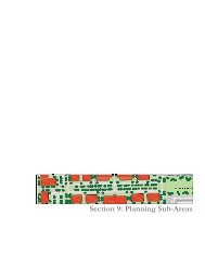
SECTION 2: LAND USE AND PHYSICAL CONDITIONS<br />
late 1920’s to the mid 1930’s, and comprise the Civic Center<br />
Historic District. Other public uses include the police station<br />
and the train station. <strong>The</strong> Pearl Street Historic District, due<br />
south <strong>of</strong> the train station, consists <strong>of</strong> four renovated historic<br />
buildings into <strong>of</strong>fice use. A more recently constructed town<br />
home development, Stationside Village is located along 13th<br />
Avenue between 52nd and 54th Street. Older single family<br />
and two family dwellings occupy the area between the railroad<br />
tracks and 10th Avenue and 57th to 58th Streets. Commercial<br />
Uses are located along the north side <strong>of</strong> 60th Street and are<br />
comprised primarily <strong>of</strong> automobile related services.<br />
49th Street<br />
50th Street<br />
Sheridan Road<br />
8th Avenue<br />
51st Street<br />
51st Place<br />
50th Street<br />
6th Avenue<br />
<strong>Kenosha</strong><br />
Harbor<br />
Island<br />
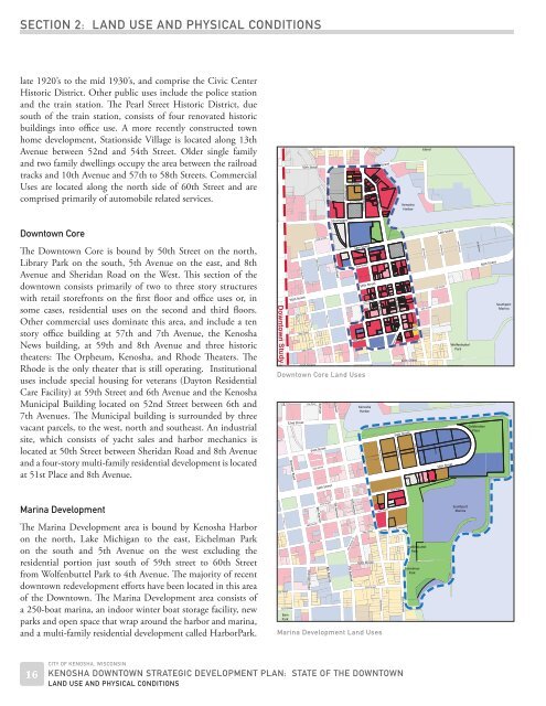
<strong>Downtown</strong> Core<br />
<strong>The</strong> <strong>Downtown</strong> Core is bound by 50th Street on the north,<br />
Library Park on the south, 5th Avenue on the east, and 8th<br />
Avenue and Sheridan Road on the West. This section <strong>of</strong> the<br />
downtown consists primarily <strong>of</strong> two to three story structures<br />
with retail storefronts on the first floor and <strong>of</strong>fice uses or, in<br />
some cases, residential uses on the second and third floors.<br />
Other commercial uses dominate this area, and include a ten<br />
story <strong>of</strong>fice building at 57th and 7th Avenue, the <strong>Kenosha</strong><br />
News building, at 59th and 8th Avenue and three historic<br />
theaters: <strong>The</strong> Orpheum, <strong>Kenosha</strong>, and Rhode <strong>The</strong>aters. <strong>The</strong><br />
Rhode is the only theater that is still operating. Institutional<br />
uses include special housing for veterans (Dayton Residential<br />
Care Facility) at 59th Street and 6th Avenue and the <strong>Kenosha</strong><br />
Municipal Building located on 52nd Street between 6th and<br />
7th Avenues. <strong>The</strong> Municipal building is surrounded by three<br />
vacant parcels, to the west, north and southeast. An industrial<br />
site, which consists <strong>of</strong> yacht sales and harbor mechanics is<br />
located at 50th Street between Sheridan Road and 8th Avenue<br />
and a four-story multi-family residential development is located<br />
at 51st Place and 8th Avenue.<br />
<strong>Downtown</strong> Study A<br />
Street<br />
oad<br />
52nd Street<br />
Sheridan Road<br />
11th Avenue<br />
56th Street<br />
57th Street<br />
58th Street<br />
11th Avenue<br />
59th Street<br />
51st Place<br />
53rd Street<br />
10th Avenue<br />
54th Street<br />
55th Street<br />
56th Street<br />
52nd Street<br />
Avenue<br />
54th Street<br />
58th Street<br />
55th Street<br />
59th Street<br />
5th Avenue<br />
57th Street<br />
60th Street 60th Street<br />
<strong>Downtown</strong> Core Land Uses<br />
10th Avenue<br />
Sheridan Road<br />
56th Street<br />
8th Avenue<br />
<strong>Kenosha</strong><br />
Harbor<br />
7th Avenue<br />
4th Avenue<br />
7t<br />
6th Avenue<br />
6th Avenue 'A'<br />
54th Street<br />
3rd Avenue<br />
57th Street<br />
5th Avenue<br />
59th Street<br />
2nd Avenue<br />
4th Avenue<br />
58th Street<br />
1st Avenue<br />
54th Street<br />
3rd Avenue<br />
57th Street<br />
56th Street<br />
2nd Avenue<br />
Wolfenbuel<br />
Park<br />
Eichelman<br />
1st Avenue<br />
Celebraon<br />
Place<br />
56th Street<br />
Southport<br />
Marina<br />
C<br />
6th Avenue<br />
Marina Development<br />
57th Street<br />
58th Street<br />
Southport<br />
Marina<br />
7th Avenue<br />
8th Avenue<br />
<strong>The</strong> Marina Development area is bound by <strong>Kenosha</strong> Harbor<br />
on the north, Lake Michigan to the east, Eichelman Park<br />
on the south and 5th Avenue on the west excluding the<br />
residential portion just south <strong>of</strong> 59th street to 60th Street<br />
from Wolfenbuttel Park to 4th Avenue. <strong>The</strong> majority <strong>of</strong> recent<br />
downtown redevelopment efforts have been located in this area<br />
<strong>of</strong> the <strong>Downtown</strong>. <strong>The</strong> Marina Development area consists <strong>of</strong><br />
a 250-boat marina, an indoor winter boat storage facility, new<br />
parks and open space that wrap around the harbor and marina,<br />
and a multi-family residential development called HarborPark.<br />
10th Avenue<br />
61st Street<br />
62nd Street<br />
Bain<br />
Park<br />
58th Street<br />
59th Street<br />
8th Avenue<br />
6th Avenue 'A'<br />
7th Avenue<br />
59th Street<br />
60th Street<br />
61st Street<br />
Marina Development Land Uses<br />
5th Avenue<br />
3rd Avenue<br />
Wolfenbuel<br />
Park<br />
Eichelman<br />
Park<br />
16<br />
CITY OF KENOSHA, WISCONSIN<br />
KENOSHA DOWNTOWN STRATEGIC DEVELOPMENT PLAN: STATE OF THE DOWNTOWN<br />
LAND USE AND PHYSICAL CONDITIONS