
You also want an ePaper? Increase the reach of your titles
YUMPU automatically turns print PDFs into web optimized ePapers that Google loves.
The bottom of the river is composed by pebble and gravel material. There are outputs of<br />
rocky breeds in the river. The analysis of the river bad processes [6] specifies absence<br />
of rearrangements of a base contour, which could be determined by existing methods.<br />
Therefore account of the river bad processes of strains in a hydraulic model was not<br />
conducted. The channel deep also does not call difficulties for navigation, therefore<br />
special dragging work on this section of the river were never conducted. The absence of<br />
the hydro technical work on recess of bottom cannot cause formation of jams of ice.<br />
The accounts of current are conducted on one-dimensional and two-dimensional<br />
models. As boundary conditions the daily of water discharge on a hydrometric post<br />
Krestovskoe were used. It is located in 100 Km above on current of the river. On this<br />
section of the river the inflow of water is very small, on a comparison with volume of<br />
water of the Lena River. It was taken only in flow of the Nuy River, the discharge of<br />
water, which reach 2000 m 3 /s. The discharge of a high water on the Nuy river passes<br />
always earlier, than on the Lena. During period of a high water on the Lena the<br />
discharge in the Nuy is reduced up to tens m 3 /s. It on two orders is less than a volume of<br />
flow of the main river. The levels of waters used for calibration of a model and a<br />
selection of factors of a roughness, undertook on being available a hydrometric posts.<br />
The thickness of ice on a hydrometric post in winter period was taken into account.<br />
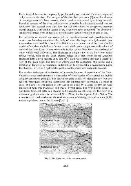
The modern technique of realization of accounts because of equations of the Saint-<br />
Venant assumes semi-automatic construction of cross section of a channel and hybrid<br />
irregular settlement grids [7]. The settlement grids consist of triangular and four-coal<br />
cells. In consequent on special algorithms they automatically interpolate a contour in<br />
knots of a grid [8]. For region of city Lensk on a site by a valley of 150 km were<br />
constructed both only triangular, and special hybrid grids. The hybrid grids consist of<br />
curvilinear four-coal cells in a channel and triangular on cells (fig. 2). The pitch of a<br />
settlement grid has made for a channel 50 − 150 m, for flood plane 150 − 500 m. The<br />
accounts were conducted under the obvious scheme of disintegration of ruptures [9,10]<br />
and on implicit on time to the scheme [2,4,11].<br />
Fig. 2. The digital nets of the computer model<br />
373