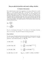

Create successful ePaper yourself
Turn your PDF publications into a flip-book with our unique Google optimized e-Paper software.
- maximum length of an ice field is known;<br />
- time (date) of a beginning of formation of a jam and its destruction are known;<br />
- on a considered site of the river a jam only one, but can form in different places of<br />
a site;<br />
- the total discharge of water and ice on the source boundaries of settlement area<br />
are known.<br />
With allowance for of listed above assumptions the one-dimensional mathematical<br />
model both program of account of formation and development of jams in region of city<br />
Lensk was developed. On this site 6 constants of places of jams are known (fig. 1).<br />
Because of digital model of a relief and with the help of especially of developed<br />
program for a site 95 cross sections of a channel and valley of the river were<br />
constructed. The cross sections are located on a distance about 1.5 Km from each other,<br />
with a pitch 25 m between verticals (on some cross sections the number of verticals<br />
reached 400).<br />
Cross sections have formed the basis for construction of a one-dimensional<br />
mathematical model of current, which has allowed to expect passing high waters on a<br />
considered site, including formation of ice jams. The model is based on a numerical<br />
solution of the one-dimensional equations of the Saint-Venant on algorithm [1, 13] and<br />
is supplemented by an elementary model of increase of length of a jam depending on<br />
concentration of ice, approaching to a jam, and flow rate at a leading edge of a jam.<br />
Basic data for a model are:<br />
- hydrograph in a first cross section, as which was accepted of the hydrograph of a<br />
post Krestovsky, with allowance for of lag channel, equal to 12 hours;<br />
- hydrograph of the river Nuy (was set to constants: Q = 100 m 3 /s);<br />
- factor of concentration of ice in a first cross section (was accepted in a range<br />
0,5 − 0,7);<br />
- place of formation of a jam (one from four specific, since of an island<br />
Batamaisky);<br />
- factors of a roughness (on Manning) the channels (n = 0,023) and flood plane of<br />
the river (n = 0,05) in a stream without ice (were determined by calibration of a<br />
model under the fact sheet);<br />
- additional factor of a roughness of a jam (ice surface), which was determined on<br />
full-scale dates for winter conditions with allowance for adjustments on an<br />
increased roughness of ice in a jam (was accepted equal n = 0,03);<br />
- maximum length of a jam (was accepted under the fact sheet or more);<br />
- time of a beginning of formation and the destructions of a jam were accepted on<br />
actual approximate dates.<br />
On the last boundary of a stream it was put the «not reflecting» boundary condition<br />
appropriate to relation between of discharges and levels accordance the equation of<br />
Shezy for known of slope of a water surface (was accepted I = 0,0001).<br />
375