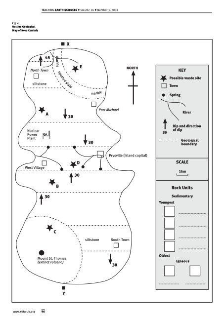
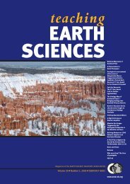
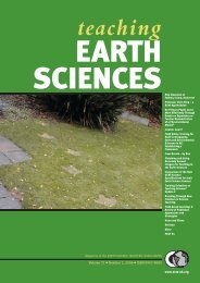
TEACHING EARTH SCIENCES ● Volume 26 ● Number 3, 2001 Fig 2: Outline Geological Map of Nova Cambria X 45 marble North Town E NORTH KEY spotted Possible waste site siltstone slate Town marble Spring A 30 Port Michael River Nuclear Power Plant 30 30 Dip and direction of dip Geological boundary Prysville (Island capital) West Village D 30 SCALE 1km B Rock Units 30 Youngest Sedimentary C siltstone South Town Mount St. Thomas (extinct volcano) 30 Oldest Igneous Y www.esta-uk.org 96
TEACHING EARTH SCIENCES ● Volume 26 ● Number 3, 2001 See Figures 1 and 2 which provide the spatial context for the decision-making exercise. The following Activities 1 - 6 are intended to show the students that some of these sites are unsuitable for locating a nuclear waste facility. As they proceed through the pack, it is envisaged that they will progressively eliminate some of the sites. Eventually they will be left with a few possibilities from which they must choose, justifying their proposals. Activity 1 - Background The first activity asks students to think about the social, economic and geological factors associated with siting the facility - this is merely “setting the scene”. Hopefully the students will be able to assess the impact of the waste facility on island life. Activity 2 - The geology of the island In this exercise, the students are provided with a set of five specimens to describe and identify. These specimens correspond to the five potential sites. Fossils are included among the specimens and the pupils should compare them with the stratigraphic column in the pack. The fossils can be used to determine the relative ages of the sedimentary rocks. Dip arrows shown on the outline map can be used by the pupils to draw a simple cross-section (see Fig 2). Activity 3 - Plate tectonic setting This section covers the hazards associated with living in a tectonically active region. <strong>Earth</strong>quakes generated in the nearby collision zone may affect the island and the students are asked to plot the epicentre of earthquakes using seismograms. Volcanic monitoring data from the island is given and the students should try to interpret the significance of the measurements. Activity 4 One of the proposed sites is located near the coast (see Fig 2). This activity examines the hazards posed by coastal processes; using historical coastline positions students can calculate the mean rate of erosion. If a sample of volcanic sand is available, the process of longshore drift can also be discussed. Activity 5 Students can use the specimens to investigate permeability. This is an important factor in the choice of location since it is important to eliminate the chance radioactive material being transported by percolating groundwater. There are also several surface watercourses on the island, many near population centres. Activity 6 Site investigation techniques are used prior to any major civil engineering project. Two examples of site investigation data are given and the students use these to locate subsurface problems in the region of one proposed site. Finally, the students are expected to fill in a short report, identifying the most appropriate choice and justifying their selection. Using the pack Geraint Price and his colleagues at the Museum have worked towards publishing this resource pack on the Internet, financially supported by the Curry Fund. It is intended that readers will be able to download the pack, (including a teachers’ guide with suggested answers) directly from the Museum’s website. Feedback The pack was presented to delegates at the ESTA 2001 Annual Conference at Kingston University and we were delighted with the positive feedback on the activities. In addition, some suggestions were made for improving and developing the pack further and I am very grateful to everyone who contributed. If any readers use the pack in their <strong>teaching</strong>, feedback would be greatly appreciated. Acknowledgements I would like to thank everyone who contributed to the development of the pack, in particular Geraint Price and his colleagues, the participants on the study day Dr Carolyn Heeps, Prof. Mike Bassett, Dr Charles Harris, Dr Pete Brabham, Dr Bob Owens and Sarah Chambers. A number of other people also contributed ideas and suggestions Dr Barbara Knowles (NERC), Dr Andrew Butcher, Dr David Bailey, Dr Glen Ford, Dr Jill Norton (all from the BGS), Dr Lesley Cherns, Dr Rod Gayer, Mr Pete Loader, Ms Jo Conway and Dr Liz Richards. I would also like to express my gratitude to the students from the two schools and to the Geologists’ <strong>Association</strong> for support from the Curry Fund. Owain Thomas Teacher i/c Geology Amman Valley School, Margaret Street, Ammanford, Carmarthenshire. SA18 2NW Tel. (01269) 592441 97 www.esta-uk.org