teaching - Earth Science Teachers' Association
teaching - Earth Science Teachers' Association
teaching - Earth Science Teachers' Association

You also want an ePaper? Increase the reach of your titles
YUMPU automatically turns print PDFs into web optimized ePapers that Google loves.
TEACHING EARTH SCIENCES ● Volume 31 ● Number 4, 2006<br />
Geodiversity, Geoconservation<br />
and GeoValue<br />
PROFESSOR PETER W. SCOTT, DR ROBIN SHAIL, DR CLIVE NICHOLAS AND DAVID ROCHE<br />
There is a much increased awareness of geodiversity and its fundamental contribution to Britain’s<br />
natural heritage. Geodiversity Action Plans (GAPs) are being introduced at local and county level.<br />
But how do you set about deciding which sites are the best for observing particular geodiversity<br />
features and, once you’ve done that, are there ways to try and improve access for geological<br />
groups? The GeoValue project hopes to help out.<br />
The Geodiversity Profile, developed as part of the<br />
GeoValue project, is a new procedure for<br />
describing and valuing geodiversity. As well as<br />
having a wider application in providing a methodology<br />
for gathering data for stakeholders, such as quarry operators,<br />
planners, conservation groups and others, it is<br />
suitable for use by educational groups as part of raising<br />
awareness of the differences in the geodiversity<br />
between sites. The data are recorded on a two-page<br />
form that summarises the geological features, records<br />
prior knowledge from literature, and values the site by<br />
comparing it with others in the area having similar<br />
characteristics. A second component of GeoValue has<br />
been addressing the legal, safety and practical issues of<br />
visiting sites on public and private land to study the<br />
geology, including active and former quarries. Even if a<br />
site is apparently open, an automatic right of access does<br />
not necessarily exist, and there are potential liability<br />
problems for both the visitor and landowner.<br />
The Geodiversity Profile<br />
The profile is a standardised quantitative procedure,<br />
with clearly defined criteria that is based on elements<br />
of best practice adopted by many Regionally Important<br />
Geological and Geomorphological Sites (RIGS)<br />
and County Geology groups. It is intended as an<br />
assessment tool to allow comparisons to be made<br />
between any sites of broadly similar geology. It is not<br />
intended as a site designation in its own right, but<br />
could be used to inform such decisions. It has been<br />
developed specifically for application to rock exposures<br />
in working, disused and abandoned quarries<br />
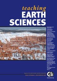
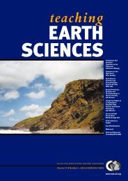
(Figure 1), although it can be applied to most geological<br />
sites. The profile is presented as a fully justified<br />
open-book statement.<br />
Data for the profile are gathered through a desk<br />
study supported by fieldwork at the site and surrounding<br />
area. The site’s geodiversity is summarised and then<br />
valued in terms of its scientific and educational importance<br />
within the context of the number of sites with<br />
similar geology that display the same features. Any<br />
applied geology features of the site, which could be<br />
mineral resources, engineering or environmental geology,<br />
hydrogeology or applied geomorphology, are also<br />
valued for both their scientific and educational importance.<br />
Historical, cultural and aesthetic attributes of the<br />
site are rated as having local, countywide, national or<br />
international importance. The profile assigns numerical<br />
values, typically 1-4, with clearly defined criteria that<br />
promote reproducibility between different assessors,<br />
and links these to justifying statements. Obvious links<br />
between geodiversity and biodiversity are recognised<br />
within the profile.<br />
The main use intended for the Geodiversity Profile<br />
is as a standardised procedure to help inform the decision-making<br />
process on a site’s future management, for<br />
example in forward development of an active quarry, in<br />
considering a former quarry for restoration, or for conservation<br />
of its geological features. It can be used to<br />
resolve conflict between stakeholders on the relative<br />
merits of a site, and as a way for establishing the best site<br />
for illustrating specific aspects of geology. It will aid in<br />
the drawing up of Geodiversity Action Plans (GAPs) by<br />
local government and other groups, and Company<br />
Continued on page 20<br />
Figure 1<br />
Sand quarry in<br />
Lower Cretaceous<br />
Lower Greensand<br />
and overlying<br />
Gault Clay,<br />
Bedfordshire, with<br />
high value<br />
geodiversity for<br />
science and<br />
education.<br />
19 www.esta-uk.org