

Appendix 11 - Basingstoke and Deane Borough Council
Appendix 11 - Basingstoke and Deane Borough Council
Appendix 11 - Basingstoke and Deane Borough Council

Create successful ePaper yourself
Turn your PDF publications into a flip-book with our unique Google optimized e-Paper software.
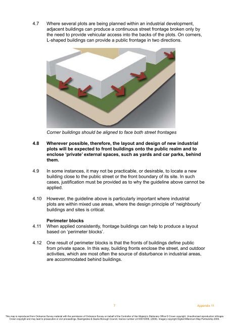
4.7 Where several plots are being planned within an industrial development,<br />
adjacent buildings can produce a continuous street frontage broken only by<br />
the need to provide vehicular access into the backs of the plots. On corners,<br />
L-shaped buildings can provide a public frontage in two directions.<br />
Corner buildings should be aligned to face both street frontages<br />
4.8 Wherever possible, therefore, the layout <strong>and</strong> design of new industrial<br />
plots will be expected to front buildings onto the public realm <strong>and</strong> to<br />
enclose ‘private’ external spaces, such as yards <strong>and</strong> car parks, behind<br />
them.<br />
4.9 In some instances, it may not be practicable, or desirable, to locate a new<br />
building close to the public street or the front boundary of its site. In such<br />
cases, justification must be provided as to why the guideline above cannot be<br />
applied.<br />
4.10 However, the guideline above is particularly important where industrial<br />
plots are within mixed use areas, where the design principle of ‘neighbourly’<br />
buildings <strong>and</strong> sites is critical.<br />
Perimeter blocks<br />
4.<strong>11</strong> When applied consistently, frontage buildings can help to produce a layout<br />
based on ‘perimeter blocks’.<br />
4.12 One result of perimeter blocks is that the fronts of buildings define public<br />
from private space. In this way, building fronts enclose the street, <strong>and</strong> outdoor<br />
activities, which are most often the source of disturbance in industrial areas,<br />
are accommodated behind buildings.<br />
7<br />
<strong>Appendix</strong> <strong>11</strong><br />
This map is reproduced from Ordnance Survey material with the permission of Ordnance Survey on behalf of the Controller of Her Majesty’s Stationery Office © Crown copyright. Unauthorised reproduction infringes<br />
Crown copyright <strong>and</strong> may lead to prosecution or civil proceedings. <strong>Basingstoke</strong> & <strong>Deane</strong> <strong>Borough</strong> <strong>Council</strong>, licence number LA100019356, (2009). Imagery copyright Digital Millennium Map Partnership 2009.


