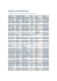
Genesee County Agricultural and Farmland Protection Plan
Genesee County Agricultural and Farmland Protection Plan
Genesee County Agricultural and Farmland Protection Plan

Create successful ePaper yourself
Turn your PDF publications into a flip-book with our unique Google optimized e-Paper software.
Agriculture <strong>and</strong> Farml<strong>and</strong> <strong>Protection</strong> <strong>Plan</strong><br />
In 1998 California signed into law what is being called “Super Williamson Act”. It allows for the<br />
conversion of existing Williamson Act agreements into 20-year contracts, thereby forming<br />
‘farml<strong>and</strong> security zones.’ In exchange for the extended term, l<strong>and</strong>owners receive a package of<br />
additional benefits, including a 35% reduction in property taxes beyond the reduction calculated<br />
under traditional contracts. Other benefits include protection from annexation by cities <strong>and</strong><br />
special districts, a reduced special tax rate for urban-related services, <strong>and</strong> a ban on school<br />
districts condemning <strong>and</strong> buying l<strong>and</strong> in farml<strong>and</strong> security zones. There are no provisions for<br />
canceling contracts before the term expires. As a result of these longer contracts, additional funds<br />
are provided by the state to the counties to make up a portion of the lost tax revenues. Since its<br />
adoption eleven counties have applied to participate. In addition, the state has recently<br />
dramatically ramped up funding of its purchase of development rights program.<br />
Strategic Mapping in Delaware<br />
An unusual convergence of circumstances in Delaware as it began its farml<strong>and</strong> protection efforts<br />
turned out to be a blessing. Faced with an approved but unfunded state program <strong>and</strong> a legal<br />
requirement to map strategic farml<strong>and</strong> in the state before buying any development rights, the<br />
Delaware Department of Agriculture embarked on a strategic mapping exercise that still leads<br />
the nation <strong>and</strong> is an integral part of a booming (<strong>and</strong> now well-funded) PDR program. They<br />
modified the LESA (L<strong>and</strong> Evaluation <strong>and</strong> Site Assessment) system to suit an area-wide analysis<br />
as opposed to a site-specific analysis. It incorporates factors such as natural soils groups,<br />
availability of sewer, l<strong>and</strong> use/l<strong>and</strong> cover, percent of area in agriculture, agricultural investment<br />
<strong>and</strong> the presence of natural areas. The result is a map with five different colors indicating lowest<br />
to highest priority for farml<strong>and</strong> preservation in the agricultural portions of the state. The ‘color’<br />
of the map area where a particular farm is located then corresponds to half of the points that farm<br />
scores on the PDR ranking system should it apply to sell an easement. The maps were the results<br />
of years of testing <strong>and</strong> public input. Using this method, state resources are directed to the most<br />
productive agricultural resources <strong>and</strong> operations that have the best chance of remaining viable.<br />
Delaware also has a situation in which agricultural zoning in its three counties is very weak <strong>and</strong><br />
function largely as rural residential development zones. Individual counties show little<br />
willingness to do anything about the agricultural zones, nor do they contribute matching dollars<br />
to the state PDR program. However, since creating an ‘agricultural districts’ is the only way to<br />
realize tax benefits, right-to-farm protections, or to be eligible to sell an easement, district<br />
participation is extremely high <strong>and</strong> may, in fact, be functioning as ‘de facto’ agricultural<br />
production zoning. Matching state funds is accomplished with l<strong>and</strong>owner discounts to their full<br />
easement values. (See Appendix IV for program description <strong>and</strong> strategic mapping criteria.)<br />
Responding Quickly to Save Critical Farms in Carroll <strong>County</strong>, Maryl<strong>and</strong><br />
Located within easy commuting distance of both Baltimore <strong>and</strong> Washington, DC, Carroll<br />
<strong>County</strong>, Maryl<strong>and</strong> set a goal for itself in the late 1970’s of permanently protecting 100,000 acres<br />
of farml<strong>and</strong>. They enacted 1:20 cluster zoning (a change from 1:1 zoning) to stabilize the l<strong>and</strong><br />
base <strong>and</strong> began vigorous participation in the state purchase of development rights program. To<br />
date they have agricultural easements on over 33,000 acres. However, they discovered that the<br />
Columbia, MD<br />
21