Display Function - Marine Autopilots, Engine Controls and Instruments
Display Function - Marine Autopilots, Engine Controls and Instruments
Display Function - Marine Autopilots, Engine Controls and Instruments

You also want an ePaper? Increase the reach of your titles
YUMPU automatically turns print PDFs into web optimized ePapers that Google loves.
Configure the output of your GPS, Plotter or PC<br />
Activate NMEA-0183 output:<br />
It is important to make the necessary settings<br />
on your Nav equipment (GPS, Plotter or<br />
PC), to activate the transmission of the route<br />
data towards the Tecnautic autopilot <strong>and</strong> instruments.<br />
Here are a few hints, for your consideration:<br />
** The Tecnautic autopilot <strong>and</strong> displays use<br />
magnetic bearings, not true bearings. It is<br />
recommended to select also magnetic bearings<br />
in the setup of your GPS or Plotter.<br />
** Create <strong>and</strong> activate a route in your Nav<br />
equipment. Verify that bearing "C", cross track<br />
error ("r" or "L") <strong>and</strong> distance to the active<br />
waypoint are displayed on your Autopilot <strong>Display</strong>.<br />
At least bearing <strong>and</strong> cross track error are<br />
required to permit the use of the autopilot NAV<br />
mode.<br />
** If your Nav equipment permits, activate<br />
only the following output sentences: APB, RMC<br />
<strong>and</strong> WDC. If this selection is not available, use<br />
other sentences from the table on page 28 (lower<br />
left), to receive the required data. For example<br />
RMC can be substituted by VTG, APB can<br />
be substituted by (BOD+XTE), BOD by<br />
(RMB+RMC), WDC by BWC.<br />
** Select a repetition rate of the sentence<br />
output as high as possible on your Nav<br />
equipment. This might be once per second,<br />
depending on your equipment.<br />
** The accuracy of the cross track error<br />
data (XTE) of the Nav equipment can be selected<br />
on some models. Select three (or<br />
more) decimal digits, if possible.<br />
The autopilot LAND mode must only be<br />
used, when at least three decimal digits of<br />
the cross track error are received. That has to<br />
be verified on the AP-<strong>Display</strong>. The third decimal<br />
remains always zero, if it has not been<br />
received by the autopilot - do not use the<br />
LAND mode in this case.<br />
The autopilot NAV mode can be used with<br />
only two decimal digits received. The resolution<br />
of the cross track error is in this case only<br />
0.010NM (18.5 meters).<br />
** The way point switching law has to be<br />
set up properly in your Nav equipment. It is<br />
recommended to select (switching to the next<br />
leg) "when abeam", or even "before abeam",<br />
where "before" should be set to 5 seconds (or<br />
0,005 NM to 0,010 NM).<br />
Without verifying this setting, your Nav<br />
equipment might switch too early to the next<br />
way point, already far ahead of the active way<br />
point.<br />
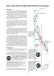
** Curved tracks: If the Nav equipment<br />
does not support curved tracks, you may split<br />
a curved approach into a series of consecutive<br />
short tracks. The difference to the next<br />
track should not exceed 20 degrees, when<br />
requiring accurate tracking in L<strong>and</strong>-Mode.<br />
Contemporary Nav equipment:<br />
All modern Nav equipment (GPS, Plotter,<br />
PC) can provide the required basic sentences<br />
for the autopilot.<br />
NMEA Input at the SERVO-wheel:<br />
From the following NMEA sentences, specific<br />
data fields are read. The data are used<br />
for displaying certain functions <strong>and</strong> for guidance<br />
of the autopilot in NAV mode.<br />
The NMEA input is not available at the remote<br />
steering wheel.<br />
APB: a) Cross Track Error<br />
b) Mag+True bearing between way<br />
points<br />
BOD: Mag bearing between waypoints<br />
BWC,BWR: Mag+True Brg <strong>and</strong> Dist of<br />
pres.pos. to WP<br />
GLL: Lat / Long<br />
HDM, HDG:Magnetic Heading<br />
MWV: Apparent Wind Angle <strong>and</strong> Speed<br />
RMB: Cross Track Error,Bearing+Distance to WP<br />
RMC: Ground Track, Speed <strong>and</strong> variation<br />
VHW: a) Magnetic Heading<br />
b) Water Speed (knots)<br />
VTG: Mag Ground Track <strong>and</strong> Speed<br />
VWR: Apparent Wind Angle <strong>and</strong> Speed<br />
WDC: Distance to Waypoint<br />
WDR: Distance to Waypoint<br />
XTE: Cross Track Error (NM)<br />
use RMB<br />
data only<br />
when also<br />
receiving<br />
RMC<br />
29