Download - MyWeb - Texas Tech University
Download - MyWeb - Texas Tech University
Download - MyWeb - Texas Tech University

Create successful ePaper yourself
Turn your PDF publications into a flip-book with our unique Google optimized e-Paper software.
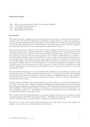
CCAP Digital Data Collection System<br />
Figure 7.4.<br />
Example of a “Field Collection”<br />
portal on a Lot form.<br />
the information for each newly imported Lot<br />
form had to be reentered in the lab computer<br />
before artifacts could be checked in and<br />
processed. This problem can be corrected in a<br />
future version of the database but will require<br />
an extensive re-design of the Lot form layout.<br />
The greatest compromise, however, between<br />
design and implementation was in the<br />
maintenance of a separate “lab master” version<br />
of the database for each site. Rather than<br />
actually syncing the databases, the procedure<br />
that developed was one that imported new data<br />
from the field iPads into the lab master, but did<br />
not export all the new data back to the iPads.<br />
This approach prevented duplicate forms from<br />
existing on the two field iPads, and that was one<br />
of the greatest problems with having multiple<br />
versions of the database operating in the field<br />
at the same time, but it meant that imported<br />
photolog entries and lab data (artifact catalog<br />
and analysis data) were not sent back into the<br />
field on the iPads. However, the greatest benefit<br />
of having all of that information integrated into<br />
the database is realized at the end of the season<br />
when the data are being reviewed to prepare<br />
excavation reports. Therefore, even though not<br />
having the lab data available in the field is seen<br />
as a weakness in the database, it is not a major<br />
issue.<br />
iDraw and the Learning Curve<br />
In the original grant proposal, drawing plan<br />
maps and profiles directly on iPads was<br />
identified as the greatest time saving part<br />
of the digital database. Unfortunately, the<br />
learning curve on iDraw is steep, and none<br />
of the graduate students attempted to use the<br />
program extensively prior to being in the field.<br />
Furthermore, because the project is a field<br />
school, using the iPads would require that each<br />
field school student be trained enough in iDraw<br />
to understand the process. Therefore, I decided<br />
that drawing plan maps and profiles on graph<br />
paper would be quicker in the field and allow<br />
the students to participate and learn important<br />
skills (Figure 7.5). I still believe, however,<br />
that with practice it is possible to create near<br />
publication-ready field drawings directly on<br />
the iPad.<br />
iPads and Filemaker Go<br />
Once the system for maintaining separate<br />
versions of the database on each iPad had been<br />
established, the system worked extremely well<br />
in the field. All of the field forms seemed to<br />
function as designed, and small bugs were<br />
noted and corrected back in the lab (see Figure<br />
7.3). One field on the Lot and Subop Definition<br />
forms that gave us the most trouble was a<br />
container in the lower right corner that was<br />
designed to hold a sketch map of lot or unit.<br />
Once we abandoned iDraw, as noted above,<br />
we resorted to snapping pictures of either<br />
the unit itself or the field drawing made on<br />
graph paper. It was not until after excavations<br />
had been completed that one of the graduate<br />
students, Vince Sisneros, realized that the<br />
“Get Signature” option, which appeared next<br />
to “Choose from Library” and “Take Photo”<br />
when you clicked on the container field, would<br />
actually allow you to quickly and easily make a<br />
sketch map. This wonderful surprise came too<br />
late for the 2012 season, but will be useful in<br />
the feature.<br />
81