Watershed Protection Plan - Lower Rio Grande Valley Development ...
Watershed Protection Plan - Lower Rio Grande Valley Development ...
Watershed Protection Plan - Lower Rio Grande Valley Development ...

Create successful ePaper yourself
Turn your PDF publications into a flip-book with our unique Google optimized e-Paper software.
WATER QUALITY MONITORING PLAN<br />
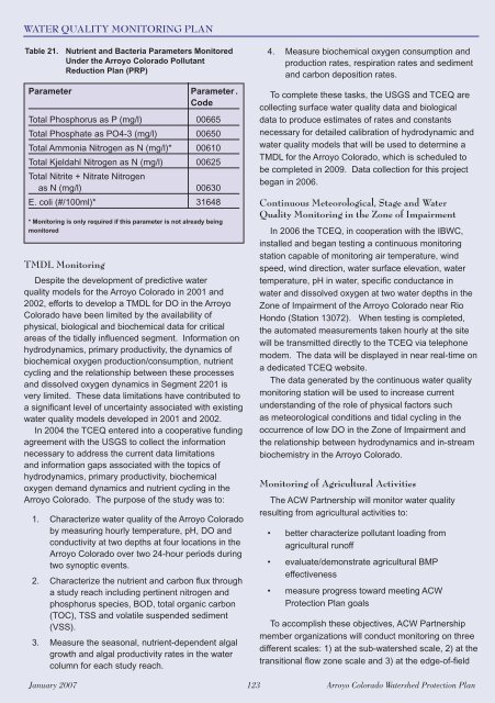
Table 21. Nutrient and Bacteria Parameters Monitored<br />
Under the Arroyo Colorado Pollutant<br />
Reduction <strong>Plan</strong> (PRP)<br />
Parameter Parameter .<br />
Code<br />
Total Phosphorus as P (mg/l) 00665<br />
Total Phosphate as PO4-3 (mg/l) 00650<br />
Total Ammonia Nitrogen as N (mg/l)* 00610<br />
Total Kjeldahl Nitrogen as N (mg/l) 00625<br />
Total Nitrite + Nitrate Nitrogen<br />
as N (mg/l) 00630<br />
E. coli (#/100ml)* 31648<br />
* Monitoring is only required if this parameter is not already being<br />
monitored<br />
TMDL Monitoring<br />
Despite the development of predictive water<br />
quality models for the Arroyo Colorado in 2001 and<br />
2002, efforts to develop a TMDL for DO in the Arroyo<br />
Colorado have been limited by the availability of<br />
physical, biological and biochemical data for critical<br />
areas of the tidally infl uenced segment. Information on<br />
hydrodynamics, primary productivity, the dynamics of<br />
biochemical oxygen production/consumption, nutrient<br />
cycling and the relationship between these processes<br />
and dissolved oxygen dynamics in Segment 2201 is<br />
very limited. These data limitations have contributed to<br />
a signifi cant level of uncertainty associated with existing<br />
water quality models developed in 2001 and 2002.<br />
In 2004 the TCEQ entered into a cooperative funding<br />
agreement with the USGS to collect the information<br />
necessary to address the current data limitations<br />
and information gaps associated with the topics of<br />
hydrodynamics, primary productivity, biochemical<br />
oxygen demand dynamics and nutrient cycling in the<br />
Arroyo Colorado. The purpose of the study was to:<br />
1. Characterize water quality of the Arroyo Colorado<br />
by measuring hourly temperature, pH, DO and<br />
conductivity at two depths at four locations in the<br />
Arroyo Colorado over two 24-hour periods during<br />
two synoptic events.<br />
2. Characterize the nutrient and carbon fl ux through<br />
a study reach including pertinent nitrogen and<br />
phosphorus species, BOD, total organic carbon<br />
(TOC), TSS and volatile suspended sediment<br />
(VSS).<br />
3. Measure the seasonal, nutrient-dependent algal<br />
growth and algal productivity rates in the water<br />
column for each study reach.<br />
4. Measure biochemical oxygen consumption and<br />
production rates, respiration rates and sediment<br />
and carbon deposition rates.<br />
To complete these tasks, the USGS and TCEQ are<br />
collecting surface water quality data and biological<br />
data to produce estimates of rates and constants<br />
necessary for detailed calibration of hydrodynamic and<br />
water quality models that will be used to determine a<br />
TMDL for the Arroyo Colorado, which is scheduled to<br />
be completed in 2009. Data collection for this project<br />
began in 2006.<br />
Continuous Meteorological, Stage and Water<br />
Quality Monitoring in the Zone of Impairment<br />
In 2006 the TCEQ, in cooperation with the IBWC,<br />
installed and began testing a continuous monitoring<br />
station capable of monitoring air temperature, wind<br />
speed, wind direction, water surface elevation, water<br />
temperature, pH in water, specifi c conductance in<br />
water and dissolved oxygen at two water depths in the<br />
Zone of Impairment of the Arroyo Colorado near <strong>Rio</strong><br />
Hondo (Station 13072). When testing is completed,<br />
the automated measurements taken hourly at the site<br />
will be transmitted directly to the TCEQ via telephone<br />
modem. The data will be displayed in near real-time on<br />
a dedicated TCEQ website.<br />
The data generated by the continuous water quality<br />
monitoring station will be used to increase current<br />
understanding of the role of physical factors such<br />
as meteorological conditions and tidal cycling in the<br />
occurrence of low DO in the Zone of Impairment and<br />
the relationship between hydrodynamics and in-stream<br />
biochemistry in the Arroyo Colorado.<br />
Monitoring of Agricultural Activities<br />
The ACW Partnership will monitor water quality<br />
resulting from agricultural activities to:<br />
• better characterize pollutant loading from<br />
agricultural runoff<br />
• evaluate/demonstrate agricultural BMP<br />
effectiveness<br />
• measure progress toward meeting ACW<br />
<strong>Protection</strong> <strong>Plan</strong> goals<br />
To accomplish these objectives, ACW Partnership<br />
member organizations will conduct monitoring on three<br />
different scales: 1) at the sub-watershed scale, 2) at the<br />
transitional fl ow zone scale and 3) at the edge-of-fi eld<br />
January 2007 123 Arroyo Colorado <strong>Watershed</strong> <strong>Protection</strong> <strong>Plan</strong>