Watershed Protection Plan - Lower Rio Grande Valley Development ...
Watershed Protection Plan - Lower Rio Grande Valley Development ...
Watershed Protection Plan - Lower Rio Grande Valley Development ...

You also want an ePaper? Increase the reach of your titles
YUMPU automatically turns print PDFs into web optimized ePapers that Google loves.
THE ARROYO COLORADO WATERSHED<br />
Arroyo Colorado was modifi ed extensively to serve<br />
as the pilot channel for the Main and Arroyo Colorado<br />
fl oodways; this included channelization and, in some<br />
sections also, the repositioning of the channel within the<br />
fl oodway. The land within the fl oodways themselves<br />
was cleared of buildings, trees and brush to reduce<br />
roughness during fl ood fl ows. To this day, the IBWC<br />
ensures that land use within the fl oodways does not<br />
diminish the ability to convey fl oodwater. This includes<br />
restricting vegetation growth and development inside<br />
the fl oodway. Unfortunately, this prevents the Arroyo<br />
Colorado from having a healthy riparian environment<br />
and contributes to the severe bank erosion observed<br />
over much of its course.<br />
In 1933, the IBWC implemented Federal Project #5,<br />
which involved cutting fi ve channels and straightening<br />
the Arroyo Colorado from Harlingen to its outlet at<br />
the Laguna Madre. The channel construction and<br />
straightening projects cut off some of the bends in<br />
the original stream channel and modifi ed the bed and<br />
banks of the tidal portion of the stream.<br />
Prior to the construction of dams on the main<br />
channel of the river, the <strong>Rio</strong> <strong>Grande</strong> overfl owed its<br />
banks annually, depositing new sediments and moving<br />
fresh water into a variety of abandoned river segments<br />
and meander channels that became cut off from the<br />
main fl ow of the river. These old abandoned channels<br />
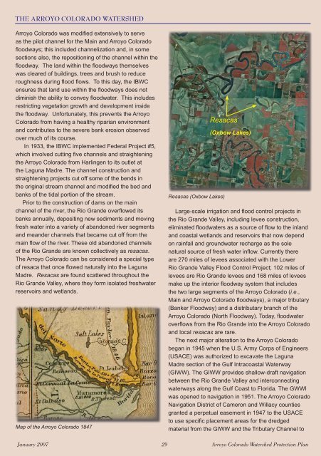
of the <strong>Rio</strong> <strong>Grande</strong> are known collectively as resacas.<br />
The Arroyo Colorado can be considered a special type<br />
of resaca that once fl owed naturally into the Laguna<br />
Madre. Resacas are found scattered throughout the<br />
<strong>Rio</strong> <strong>Grande</strong> <strong>Valley</strong>, where they form isolated freshwater<br />
reservoirs and wetlands.<br />
Map of the Arroyo Colorado 1847<br />
Resacas<br />
Resacas (Oxbow Lakes)<br />
(Oxbow Lakes)<br />
Large-scale irrigation and fl ood control projects in<br />
the <strong>Rio</strong> <strong>Grande</strong> <strong>Valley</strong>, including levee construction,<br />
eliminated fl oodwaters as a source of fl ow to the inland<br />
and coastal wetlands and reservoirs that now depend<br />
on rainfall and groundwater recharge as the sole<br />
natural source of fresh water infl ow. Currently there<br />
are 270 miles of levees associated with the <strong>Lower</strong><br />
<strong>Rio</strong> <strong>Grande</strong> <strong>Valley</strong> Flood Control Project; 102 miles of<br />
levees are <strong>Rio</strong> <strong>Grande</strong> levees and 168 miles of levees<br />
make up the interior fl oodway system that includes<br />
the two large segments of the Arroyo Colorado (i.e.,<br />
Main and Arroyo Colorado fl oodways), a major tributary<br />
(Banker Floodway) and a distributary branch of the<br />
Arroyo Colorado (North Floodway). Today, fl oodwater<br />
overfl ows from the <strong>Rio</strong> <strong>Grande</strong> into the Arroyo Colorado<br />
and local resacas are rare.<br />
The next major alteration to the Arroyo Colorado<br />
began in 1945 when the U.S. Army Corps of Engineers<br />
(USACE) was authorized to excavate the Laguna<br />
Madre section of the Gulf Intracoastal Waterway<br />
(GIWW). The GIWW provides shallow-draft navigation<br />
between the <strong>Rio</strong> <strong>Grande</strong> <strong>Valley</strong> and interconnecting<br />
waterways along the Gulf Coast to Florida. The GWWI<br />
was opened to navigation in 1951. The Arroyo Colorado<br />
Navigation District of Cameron and Willacy counties<br />
granted a perpetual easement in 1947 to the USACE<br />
to use specifi c placement areas for the dredged<br />
material from the GIWW and the Tributary Channel to<br />
January 2007 29 Arroyo Colorado <strong>Watershed</strong> <strong>Protection</strong> <strong>Plan</strong>