

Practical Manual - Malareo
Practical Manual - Malareo
Practical Manual - Malareo

Create successful ePaper yourself
Turn your PDF publications into a flip-book with our unique Google optimized e-Paper software.
This adds the shapefile to the legend and view.<br />
Next you will add a CAD layer consisting of the Provinces of Zimbabwe.<br />
Add a vector layer and choose DXF as the input type (This is an Autocad Format) Select<br />
Provinces_Zim.dxf from the Directory and select open. Notice it add a layer called entities map legend<br />
and places a series of polygons into the map view. Zoom to full extents to view the layers. Right click on<br />
the layer and open the attribute table. Notice there are no Province names associated with the polygons<br />
(this is a problem with importing CAD to GIS, as each separate layer including text entities are separate<br />
layers and as a result the labels are in this case lost.)<br />
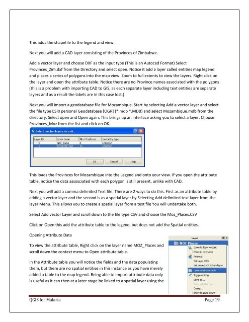
Next you will import a geodatabase file for Mozambique. Start by selecting Add a vector layer and select<br />
the file type ESRI personal Geodatabase [OGR] (*.mdb *.MDB) and select Mozambique.mdb from the<br />
directory. Select open and Open again. This brings up an interface asking you to select a layer, Choose<br />
Provinces_Moz from the list and click on OK.<br />
This loads the Provinces for Mozambique into the Legend and onto your view. If you open the attribute<br />
table, notice the data assosciated with each polygon is still present, unlike with CAD.<br />
Next you will add a comma delimited Text file. There are 2 ways to do this. First as an attribute table by<br />
adding a vector layer and the second is as a spatial layer by Selecting Add delimited text layer from the<br />
layer Menu. This allows you to create a spatial layer from a text file You will undertake both.<br />
Select Add vector Layer and scroll down to the file type CSV and choose the Moz_Places.CSV<br />
Click on Open this add the attribute table to the legend, but does not add the Spatial entities.<br />
Opening Attribute Data<br />
To view the attribute table, Right click on the layer name MOZ_Places and<br />
scroll down the context menu to Open attribute table.<br />
In the Attribute table you will notice the fields and the data populating<br />
them, but there are no spatial entities in this instance as you have merely<br />
added a table to the map legend. Being able to import attribute data only<br />
is useful as it can then at a later stage be linked to a spatial layer using the<br />
QGIS for Malaria Page 19

