

Practical Manual - Malareo
Practical Manual - Malareo
Practical Manual - Malareo

You also want an ePaper? Increase the reach of your titles
YUMPU automatically turns print PDFs into web optimized ePapers that Google loves.
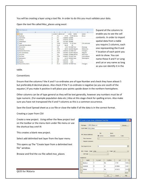
You will be creating a layer using a text file. In order to do this you must validate your data.<br />
Open the text file called Moz_places using excel.<br />
table.<br />
Expand all the columns to<br />
enable you to see the cell<br />
contents. In order to import<br />
spatial data from a table<br />
you require 2 columns, each<br />
one representing the X and<br />
Y location of each point you<br />
wish to show. You can<br />
name these X and Y or Long<br />
and Lat or any name as long<br />
as you can identify it in the<br />
Conventions<br />
Ensure that the columns f the X and Y co-ordinates are of type Number and check they have atleast 5<br />
but preferably 8 decimal places. Also check if the Y co-ordinate is negative (as you are south of the<br />
equator.) If you make it positive it will place your points upside down in the northern hemisphere.<br />
Other columns can be of type general as they will be text generally, however any numbers must be of<br />
type numeric. (For example population data etc.) Also at this stage check for spelling errors. Also make<br />
sure you have not transposed the X and Y columns as this is a common occurrence.<br />
Save the Excel Spread sheet as a csv file or close the table if all the data is in the correct format.<br />
Creating a Layer from CSV<br />
Create a new project. Using either the New project tool<br />
on the toolbar or the menu item under file menu or use<br />
the shortcut key cntrl-N<br />
This creates a blank new project.<br />
Select add delimited text layer from the layer menu<br />
This opens up The “Create layer from a delimited text<br />
file” window.<br />
Browse and find the csv file called moz_places<br />
QGIS for Malaria Page 21

