Odonata - Entomological Society of Latvia - Latvijas Daba
Odonata - Entomological Society of Latvia - Latvijas Daba
Odonata - Entomological Society of Latvia - Latvijas Daba

You also want an ePaper? Increase the reach of your titles
YUMPU automatically turns print PDFs into web optimized ePapers that Google loves.
2.3. RESEARCH OF THE OCCURRENCE AND POPULATION DENSITY OF GOMHIDAE LARVAE IN RIVER<br />
GAUJA<br />
Sampling. Gomphidae larvae were collected during implementation <strong>of</strong> the project<br />
„Establishment <strong>of</strong> long-term pollution in water <strong>of</strong> Gauja” in 1998. In total 280 quantitative samples<br />
<strong>of</strong> macrozoobenthos were collected at 32 sampling sites in the river Gauja from village Taurene<br />
upstream to village Carnikava downstream. Standardized methods were used for collecting and<br />
processing the Gomphidae material (Standart… 1992). At each sampling site 2-4 quantitative<br />
macrozoobenthos samples were collected. At most <strong>of</strong> the sites the samples were collected during<br />
three seasons. An Ekmans–Berdge type grab (0.025 m 2 ) was used for collecting quantitative<br />
samples. 1-2 qualitative samples were collected at each sampling site, using a hydrobiological handnet.<br />
In total 65 qualitative samples were obtained. In each sample spot the substrate composition<br />
and the speed <strong>of</strong> the stream (using a floating object, by formula: speed <strong>of</strong> the stream (v) = distance<br />
(s) / time (t)) were determined. The vegetation was described using Braun-Blanquet scale (Kent,<br />
Coker 1996). The ground composition was evaluated visually, registering the percentage <strong>of</strong> ground<br />
composition: cobbles (>256 mm), pebbles (64-256 mm), gravel (2-64 mm), sand (0.06-2 mm), mud<br />
and detritus.<br />
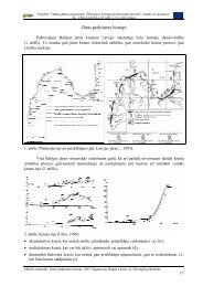
Additionally, a survey <strong>of</strong> Ophiogomphus cecilia imagos was performed in Gauja, July 29-30,<br />
2003 in the section from Cēsis to Sigulda (45 km), where all adult individuals near the river and its<br />
banks were recorded. The survey was performed in sunny conditions, from 11:00 till 16:00. The<br />
observation places were recorded by GPS and marked in a map.<br />
Data analysis For the analysis and the interpretation the data from the observations <strong>of</strong> adult<br />
individuals were used, including literature and unpublished observations from 1993-2005 (basic<br />
data base). The density <strong>of</strong> larvae was estimated from the total number <strong>of</strong> collected samples and the<br />
number <strong>of</strong> the Gomphidae samples. In this way, the total density <strong>of</strong> the Gomphidae larvae in Gauja<br />
and the density <strong>of</strong> the individuals in the Gomphidae habitats were obtained. The imago observations<br />
were used to describe the distribution <strong>of</strong> the species in Gauja area.<br />
2.4. RESEARCH OF THE REGIONAL DIFFERENCES OF THE EUROPEAN ENDANGERED AND<br />
PROTECTED DRAGONFLY SPECIES IN LATVIA<br />
All species. For the analysis <strong>of</strong> species distribution and populated habitats the basic data from<br />
data bases were used. Data on the relation <strong>of</strong> the species to specific habitats and vegetation were<br />
obtained by using:<br />
• information from data base;<br />
• descriptions <strong>of</strong> localities in literature;<br />
• descriptions <strong>of</strong> localities and photos obtained during inventories;<br />
• orthophotomaps, thematic data layers (<strong>Latvia</strong>n Geospatial Information Agency, Envirotech,<br />
Ltd.);<br />
• data from http://www.ezeri.lv (2011).<br />
Additional data were obtained during the research by describing and taking photographs <strong>of</strong> research<br />
locations on various scales (landscape, habitat, micro habitat, plant species).<br />
The area and distance measurements were performed by using the first (1994-1999), second<br />
(2003-2005) and third (2007-2008) cycle othophotomaps on a scale <strong>of</strong> 1:10 000 available for the<br />
specific location and time (<strong>Latvia</strong>n Geospatial Information Agency) and Arc GIS 9 program<br />
package.<br />
Nehalennia speciosa. In order to identify the species the habitats (lakes with fens and bogmoss,<br />
poor fens and raised bogs with water bodies <strong>of</strong> various sizes) and micro habitats potentially<br />
suitable for the species (imagos) were searched for the individual imagos using an insect net. The<br />
micro habitats (vegetation where individual imagos were observed) were described, accounting for<br />
the vegetation, the area and shape <strong>of</strong> the micro habitat and its location in the habitat. The<br />
individuals observed in each micro habitat were counted. The inventory was carried out on the<br />
49