

2 Renmark to border LAP area assessment - EPA - Sa.gov.au
2 Renmark to border LAP area assessment - EPA - Sa.gov.au
2 Renmark to border LAP area assessment - EPA - Sa.gov.au

You also want an ePaper? Increase the reach of your titles
YUMPU automatically turns print PDFs into web optimized ePapers that Google loves.
River Murray and Lower Lakes catchment risk <strong>assessment</strong> for water quality: Results and management options<br />
Risks <strong>to</strong> raw water supplies<br />
Figure 4.4 is the key map for risks <strong>to</strong> the raw water supply environmental value in the RW <strong>LAP</strong> <strong>area</strong>. The<br />
attached CD has individual maps numbered according <strong>to</strong> the key map.<br />
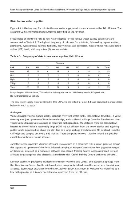
Frequencies of identified risks <strong>to</strong> raw water supplies for the various water quality parameters are<br />
summarised in Table 4.3. The highest frequency of risks was for nutrients, followed by organic matter,<br />
pathogens, hydrocarbons, salinity, turbidity, heavy metals and pesticides. Most of these risks were rated<br />
as low (162) level, with only a few (6) moderate risks.<br />
Table 4.3 Frequency of risks <strong>to</strong> raw water supplies, RW <strong>LAP</strong> <strong>area</strong><br />
PA—pathogens; NU—nutrients; TU—turbidity; OR—organic matter; HM—heavy metals; PE—pesticides;<br />
HY—hydrocarbons; SA—salinity<br />
The raw water supply risks identified in this <strong>LAP</strong> <strong>area</strong> are listed in Table 4.4 land discussed in more detail<br />
below for each stressor.<br />
Pathogens<br />
Waste disposal systems (Cadell shacks, Waikerie riverfront septic tanks, Blanche<strong>to</strong>wn <strong>to</strong>wnship), a vessel<br />
mooring <strong>area</strong> just upstream of Blanche<strong>to</strong>wn bridge, and accidental spillage from the Blanche<strong>to</strong>wn river<br />
vessel waste disposal were assessed as moderate pathogen risks. The distance from the Blanche<strong>to</strong>wn<br />
hazards <strong>to</strong> the off-take is reasonably large (>350 m) but effluent from the vessel station and adjoining<br />
public <strong>to</strong>ilets is pumped up above the cliff line <strong>to</strong> a large soakage trench located 50 m inland from the<br />
cliff edge and pumped out every 6–12 months. There are plans <strong>to</strong> move it further inland and possibly<br />
establish a wastewater reuse scheme.<br />
Jaeschke lagoon (opposite Waikerie off-take) was assessed as a moderate risk—animals graze all around<br />
the lagoon and upstream of the ferry. Informal camping at Morgan Conservation Park (opposite Morgan<br />
off-take) was assessed as a moderate pathogen risk. Cadell Training Centre lagoon (degraded wetland<br />
affected by grazing) was also classed as a moderate risk (Cadell Training Centre unfiltered off-take).<br />
Low risk sources of pathogens included ferry runoff (Waikerie and Cadell) and accidental spillage from<br />
the River Murray Queen. Double reinforced pipes pump waste inland from this vessel so a low risk was<br />
assigned. S<strong>to</strong>rmwater discharge from the McCutcheon Street catchment in Waikerie was classified as a<br />
low pathogen risk as it is over one kilometre upstream from the off-take.<br />
100<br />
Stressor<br />
Risk PA NU TU OR HM PE HY SA Total<br />
Low 18 20 6 19 4 1 16 9 93<br />
Mod 2 2 0 2 0 0 0 0 6<br />
High 0 0 0 0 0 0 0 0 0<br />
V high 0 0 0 0 0 0 0 0 0<br />
Total 20 22 6 21 4 1 16 9 99


