

2 Renmark to border LAP area assessment - EPA - Sa.gov.au
2 Renmark to border LAP area assessment - EPA - Sa.gov.au
2 Renmark to border LAP area assessment - EPA - Sa.gov.au

You also want an ePaper? Increase the reach of your titles
YUMPU automatically turns print PDFs into web optimized ePapers that Google loves.
River Murray and Lower Lakes catchment risk <strong>assessment</strong> for water quality: Results and management options<br />
Risks <strong>to</strong> recreational use<br />
Figure 7.5 is the key map for risks <strong>to</strong> the raw water supply environmental value in the GW & CD <strong>LAP</strong><br />
<strong>area</strong>s. The attached DVD has individual maps numbered according <strong>to</strong> the key map.<br />
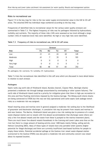
Frequencies of identified risks <strong>to</strong> recreational values for the various water quality stressors are<br />
summarised in Table 7.3. The highest frequency of risks was for pathogens followed by hydrocarbons,<br />
turbidity and nutrients. The majority of these risks (149) were assessed as low level although a large<br />
number (103) of moderate-level risks were identified. No high or very high risks were identified.<br />
Table 7.3 Frequency of risks <strong>to</strong> recreational use, GW & CD <strong>LAP</strong> <strong>area</strong>s<br />
PA—pathogens; NU—nutrients; TU—turbidity; HY—hydrocarbons<br />
Table 7.4 lists the recreational risks identified in this <strong>LAP</strong> <strong>area</strong> which are discussed in more detail below<br />
in relation <strong>to</strong> each stressor.<br />
Pathogens<br />
Septic tanks (eg north side of Hindmarsh Island, Mundoo channel, Clay<strong>to</strong>n West, Meningie shacks)<br />
presented a moderate risk through leakage (exacerbated by overloading or other system failures). The<br />
north side of Hindmarsh Island could be a priority for mitigation given that there is high-use recreation in<br />
this <strong>area</strong> and flow/flushing restrictions imposed by the Goolwa barrage. The Milang south shores shacks<br />
are being connected <strong>to</strong> STEDS but this was not fully operational (still some septic tank soakage trench<br />
risks) so a moderate risk was assigned.<br />
Vessel mooring <strong>area</strong>s and marinas were in general assigned a moderate risk ranking due <strong>to</strong> the likelihood<br />
of greywater and blackwater discharges. A cumulative risk may be present from vessels and marinas in<br />
and near Goolwa. The Marina, Hindmarsh Island was given a low risk ranking due <strong>to</strong> presence of a vessel<br />
waste disposal station and no vessels with live-aboard accommodation that discharge waste (there are<br />
only a few live-aboard vessels and the waste from these is pumped <strong>to</strong> the marina treatment plant).<br />
There are much fewer live-aboard vessels/houseboats in the Coorong and Lower Lakes <strong>area</strong> than on the<br />
river but there is a large amount of boating activity (over 1400 boats mainly fishing, sailing and ski,<br />
Helicon Consulting 2003). Many of these types of vessels have only portable <strong>to</strong>ilet systems (higher<br />
potential for illegal discharge) and there are currently insufficient land-based facilities for people <strong>to</strong><br />
empty these <strong>to</strong>ilets. Potential accidental spillage at the Goolwa river vessel waste disposal station<br />
(connected <strong>to</strong> the Goolwa STEDS) was also given a moderate risk and community concern was raised<br />
about its exposed location.<br />
210<br />
Stressor<br />
Risk PA NU TU HY Total<br />
Low 21 41 22 65 149<br />
Moderate 61 7 35 0 103<br />
High 0 0 0 0 0<br />
Very high 0 0 0 0 0<br />
Total 82 48 57 65 252


