

2 Renmark to border LAP area assessment - EPA - Sa.gov.au
2 Renmark to border LAP area assessment - EPA - Sa.gov.au
2 Renmark to border LAP area assessment - EPA - Sa.gov.au

You also want an ePaper? Increase the reach of your titles
YUMPU automatically turns print PDFs into web optimized ePapers that Google loves.
River Murray and Lower Lakes catchment risk <strong>assessment</strong> for water quality: Results and management options<br />
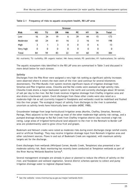
Table 2.1 Frequency of risks <strong>to</strong> aquatic ecosystem health, RB <strong>LAP</strong> <strong>area</strong><br />
Stressor<br />
Risk NU TU OR HM PE HY SA Total<br />
Low 16 34 19 6 39 44 15 173<br />
Moderate 65 24 61 16 2 16 14 198<br />
High 3 1 3 0 0 0 6 13<br />
Very high 0 0 0 0 0 0 0 0<br />
Total 84 59 83 22 41 60 35 384<br />
NU—nutrients; TU—turbidity; OR—organic matter; HM—heavy metals; PE—pesticides; HY—hydrocarbons; SA—salinity<br />
The aquatic ecosystem risks identified in the RB <strong>LAP</strong> <strong>area</strong> are summarised in Table 3 and discussed in<br />
more detail below for each stressor.<br />
<strong>Sa</strong>linity<br />
Discharges from the Pike River were assigned a very high risk ranking as significant salinity increases<br />
were observed where it enters the main stem of the river (and continue for several kilometres<br />
downstream). The Pike-Mundic river system receives significant inputs of irrigation drainage from<br />
Simarloo and Pike irrigation <strong>area</strong>s. Chowilla and Ral Ral creeks were assessed as high salinity risks.<br />
Chowilla Creek drains a major backwater system <strong>to</strong> the north and currently discharges about 30 <strong>to</strong>nnes<br />
of salt per day <strong>to</strong> the river. Ral Ral Creek receives irrigation drainage from Chaffey irrigation <strong>area</strong> and<br />
also drains a backwater system. Event discharges from these other creeks were also rated as a<br />
moderate-high risk as salt (currently trapped in floodplains and wetlands) could be mobilised and flushed<br />
in<strong>to</strong> the river proper. The ecological impact of salinity from discharges <strong>to</strong> the river is somewhat<br />
uncertain as salinity levels have his<strong>to</strong>rically been variable (MDBC 1988).<br />
Groundwater leakage from large horticultural/irrigation <strong>area</strong>s (Murtho, Chaffey, Simarloo, <strong>Renmark</strong>,<br />
Paringa, Pike) adjacent <strong>to</strong> the river made up most of the other moderate-high salinity risk ratings, and a<br />
pumped drainage discharge <strong>to</strong> Ral Ral Creek from Chaffey irrigation district also received a high-risk<br />
rating. Large <strong>area</strong>s of irrigated horticultural land adjacent <strong>to</strong> the river in the <strong>Renmark</strong> <strong>to</strong> Border <strong>LAP</strong><br />
<strong>area</strong> are predominantly used <strong>to</strong> grow citrus fruit and grapes.<br />
Bookmark and Nelwart creeks were noted as moderate risks during event discharges (large rainfall events<br />
and/or artificial flooding). They may receive irrigation drainage input from <strong>Renmark</strong> irrigation <strong>area</strong> and<br />
other catchment sources. Flows in and out of Bookmark Creek are regulated, with maximum salinity<br />
targets set for the discharge.<br />
Event discharges from wetlands (Whirlpool Corner, Mundic Creek, Temple<strong>to</strong>n) also presented a lowmoderate<br />
salinity risk. Basic moni<strong>to</strong>ring has recently been conducted at Temple<strong>to</strong>n wetlands as part of<br />
the River Murray Wetlands Baseline Survey 4 .<br />
Several management strategies are already in place or planned <strong>to</strong> reduce the effects of salinity on the<br />
river, and floodplain and wetland vegetation. Several district schemes operate <strong>to</strong> collect and pump<br />
irrigation drainage water <strong>to</strong> regional disposal basins.<br />
4 See the website <br />
25


