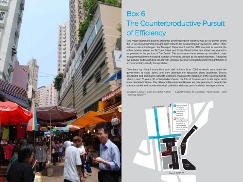
Box 6The Counterproductive Pursuit<strong>of</strong> EfficiencyOne major example <strong>of</strong> seeking efficiency at <strong>the</strong> expense <strong>of</strong> vibrancy was at The Zenith, where<strong>the</strong> URA’s redevelopment brought more traffic to <strong>the</strong> surrounding narrow streets. In <strong>the</strong> 1990s,before construction began, <strong>the</strong> Transport Department and <strong>the</strong> LDC intended to relocate <strong>the</strong>entire outdoor market on Tai Yuen Street and Cross Street to <strong>the</strong> new indoor wet market tobe provided in <strong>the</strong> podium <strong>of</strong> The Zenith. This would open those streets up to traffic in orderto accommodate <strong>the</strong> increased number <strong>of</strong> vehicles brought by <strong>the</strong> redevelopment. Replacingtwo popular pedestrianized streets with vehicular corridors would have been <strong>the</strong> anti<strong>the</strong>sis <strong>of</strong>environmentally-friendly transportation.88Objections by district councillors and stall holders from 2005 onwards persuaded <strong>the</strong>government to scale down, and <strong>the</strong>n abandon <strong>the</strong> relocation plans altoge<strong>the</strong>r. Districtcouncillors and community activists wanted to maintain <strong>the</strong> character <strong>of</strong> <strong>the</strong> existing market,which is over 70 years old, while hawkers feared <strong>the</strong> loss <strong>of</strong> business and much higher rentsonce relocated indoors. The URA and Development Bureau are now planning to beautify <strong>the</strong>outdoor market and provide electrical outlets for stalls as part <strong>of</strong> a district heritage scheme.Sources: LegCo Panel on Home Affairs — Subcommittee on Heritage Preservation; TownPlanning Board 178Tai Yuen StreetCross StreetJohnston RoadStone Nullah LaneN1990s. Completerelocation <strong>of</strong>market proposed.2006. Partialrelocationproposed.2007. Wholemarket preserved.Restricted accessto Tai Yuen St.Zenith loadingbay to be used asturning circle.Tai Wo StreetCross StreetZenithSite AZenithSite BZenithSite BWanchai RoadIndoor MarketZenithSite CQueen’s Road East
TrafficOne <strong>of</strong> <strong>the</strong> goals <strong>of</strong> <strong>the</strong> URA laid out in <strong>the</strong> Urban RenewalStrategy is “designing more effective and environmentallyfriendlylocal transport and road networks”. In practice, thismeans that large sites are re-planned to increase efficiencyand reduce circulating traffic around <strong>the</strong> site boundaries.Traffic engineers have traditionally favoured comprehensivedevelopments because <strong>the</strong>y can more efficientlyaccommodate traffic using <strong>the</strong> following measures, whileusing up less floor area:1.2.3.4.Reducing <strong>the</strong> number <strong>of</strong> entrances and exits on street.Fewer entrances leading to internal service lanes,drop-<strong>of</strong>f points, taxi ranks, bus stops, and loading baysreduce <strong>the</strong> need to stop on-street.Eliminating cross streets. In addition to providing extradevelopable GFA, cross streets are removed becausefrequent intersections disrupt <strong>the</strong> flow <strong>of</strong> traffic.Providing <strong>of</strong>f-street parking so that cars do not have topark at <strong>the</strong> kerb, narrowing roads and reducing trafficflow.Widening roads. Where possible, building setbacks areprovided in order to widen existing roads.Yet <strong>the</strong> benefits are not clear-cut. Reducing circulatingtraffic may encourage rat-running, i.e. speeding throughminor roads to avoid more congested arterial roads. Newlydecongested roads may also attract more traffic and fillup again. The provision <strong>of</strong> <strong>of</strong>f-street parking can also becounter-productive, because it encourages car ownershipand driving. 176Additionally, because URA redevelopments substantiallyincrease density, <strong>the</strong>y may bring more traffic to <strong>the</strong>neighbourhood. The relationship between density andtraffic congestion is not straightforward — it dependson many local factors like <strong>the</strong> shape <strong>of</strong> <strong>the</strong> site, whe<strong>the</strong>r<strong>the</strong> front entrance is near a key junction, <strong>the</strong> layout andcapacity <strong>of</strong> <strong>the</strong> surrounding streets, and whe<strong>the</strong>r <strong>the</strong> site iswell-served by public transportation. None<strong>the</strong>less <strong>the</strong>re is arisk that <strong>the</strong> additional pressure on arterial routes may wipeout efficiencies gained from reducing circulating trafficcongestion around <strong>the</strong> site boundaries.While major URA developments are required to submittraffic impact assessments to <strong>the</strong> TPB, <strong>the</strong>se assessmentsare not necessarily reliable because it is in <strong>the</strong> interest <strong>of</strong><strong>the</strong> applicant to use assumptions and figures that portray<strong>the</strong> project in a favourable light. 177 While <strong>the</strong> TPB andTransport Department may reject <strong>the</strong> assessment if <strong>the</strong>figures seem too unrealistic, this is not a substitute for anunbiased assessment.From an urban design point <strong>of</strong> view, <strong>the</strong>se trafficimprovements <strong>of</strong>ten result in pedestrian-unfriendlyenvironments. Reducing entrances, eliminating crossstreets, and prioritizing vehicular movement reducespedestrian permeability, reduces active frontages, andremoves vibrancy. Multi-storey car parks and large busterminuses can also be eyesores.There are alternative ways <strong>of</strong> dealing with traffic in districtswith narrow streets and small blocks, which are friendlierto pedestrians and <strong>the</strong> environment. They include trafficcalming, traffic restraint, and pedestrianization. Instead <strong>of</strong>trying to increase <strong>the</strong> flow <strong>of</strong> traffic, <strong>the</strong> goal is to prioritizepedestrians. Pavement widening, carriageway narrowing,reducing parking facilities, tree planting, kerbless crossingsand vehicle restrictions aim to physically and psychologicallyslow cars down and discourage vehicle use.This sort <strong>of</strong> traffic management is relatively new to HongKong, having been first trialled by <strong>the</strong> Transport Departmentin <strong>the</strong> early 2000s in selected districts. The URA has onlyvery recently started to incorporate some <strong>of</strong> <strong>the</strong>se ideasinto its projects in a piecemeal way. It has reduced parkingfacilities at <strong>the</strong> Graham Street/Peel Street project, and hasincorporated limited pedestrian schemes into traditionalCDAs such as <strong>the</strong> Hanoi Road K11 project. Lee TungStreet will be pedestrianized after redevelopment, but onlyif <strong>the</strong> adjacent Amoy Street is opened up to through traffic.The URA announced its biggest traffic calming scheme s<strong>of</strong>ar in late 2009: a revitalization project for Mong Kok’sspecialized shopping streets 179 as part <strong>of</strong> <strong>the</strong> PlanningDepartment’s “Area Improvement Plan for Shopping Areasin Mongkok”. 18089
- Page 7:
The Local Context:Evolving Communit
- Page 10 and 11:
Hong Kong Urban Design ConcernsHong
- Page 12 and 13:
12In 1998, the Planning Department
- Page 14 and 15:
Part I:14The URA —A Redevelopment
- Page 16 and 17:
Version 2:The Urban RenewalAuthorit
- Page 18 and 19:
URA Ordinance vs.Urban Renewal Stra
- Page 20 and 21:
How The URA WorksThe Cycle ofResump
- Page 22 and 23:
PART II:22The PoliticalEconomyof th
- Page 24 and 25:
The Institutional ContextNationaliz
- Page 26 and 27:
26traditionally given the Lands Dep
- Page 28 and 29:
28maximum allowable plot ratio —
- Page 31 and 32:
Left: Multi-ownership with inadequa
- Page 33 and 34:
Weak building maintenanceregulation
- Page 35 and 36:
Lack of FinancingOne significant pr
- Page 37 and 38: Left: Graham Streetrequirement. 137
- Page 39 and 40: Left: Graham Streetthe 1970s to ind
- Page 41 and 42: From the point of view of private d
- Page 43 and 44: The Built EnvironmentPart I discuss
- Page 45 and 46: Left: The K11 shopping mall, hotel,
- Page 48 and 49: Box 4Calculating Plot RatioPlot rat
- Page 50 and 51: 50Standardized ArchitectureStandard
- Page 53 and 54: Left: Langham Place, blank facade o
- Page 56 and 57: 56Figure-ground diagram of Langham
- Page 58 and 59: 58This page: Footbridge network ove
- Page 61: Left: Wo Tik Street - the only acti
- Page 65 and 66: Public Open Spaces and Pedestrian P
- Page 67 and 68: The MertonThe Merton in Kennedy Tow
- Page 69 and 70: Left: The widened pavement along Sh
- Page 71 and 72: Langham PlaceThere are often paveme
- Page 73 and 74: Recreational Public Open SpacesQuan
- Page 75: Hanoi Road K11 Open SpaceSize: 1,20
- Page 78 and 79: 78Clockwise from left: The ground f
- Page 81 and 82: The MertonTotal size (sites A and B
- Page 83 and 84: General ObservationsLandscapingGene
- Page 85: The URA also announced that it had
- Page 91 and 92: Opposite, clockwise from top right:
- Page 93 and 94: Social ImpactSocially sustainable d
- Page 96 and 97: Left: Western Market has become pri
- Page 98 and 99: 98This spread from left: This anony
- Page 100 and 101: Top: A naturally gentrified street
- Page 102 and 103: 102Comprehensive redevelopment disp
- Page 104 and 105: 104Luxury shopping at the K11 mall
- Page 106 and 107: 106A building rehabilitated by the
- Page 108 and 109: According to town planner Ian Brown
- Page 110 and 111: 110
- Page 112 and 113: 112Wan Chai Market. Built in 1937,
- Page 114 and 115: 114
- Page 116 and 117: 116
- Page 118 and 119: 118Conclusion
- Page 120 and 121: 120
- Page 122 and 123: Appendix 1Name of projectAddress/lo
- Page 124 and 125: Name of projectAddress/locationArea
- Page 126 and 127: 126Endnotes1 HKSAR Planning Departm
- Page 128 and 129: 128110 Chan, B. W. (2002), “The h
- Page 130: Room 701, Hoseinee House,69 Wyndham