<strong>Feasibility</strong> <strong>of</strong> <strong>Fish</strong> <strong>Passage</strong> <strong>at</strong> <strong>Alameda</strong> <strong>Creek</strong> <strong>Diversion</strong> <strong>Dam</strong>Habit<strong>at</strong> surveys were conducted in August and September 2006, to assess existing habit<strong>at</strong> conditions forO. mykiss in a reach <strong>of</strong> <strong>Alameda</strong> <strong>Creek</strong> th<strong>at</strong> stretches upstream from Camp Ohlone for approxim<strong>at</strong>ely3.9 miles (Hagar and Paine, 2008). All life stages <strong>of</strong> rainbow trout were seen consistently throughout thewetted portions <strong>of</strong> the survey reach, which provide suitable spawning and rearing conditions for steelhead.Steep boulder falls present fish passage obstacles <strong>at</strong> three loc<strong>at</strong>ions, one <strong>of</strong> which may be impassable <strong>at</strong> allbut extreme high flows. The creek was intermittent beginning approxim<strong>at</strong>ely 0.3 mile upstream <strong>of</strong> CampOhlone, through an alluvial valley, before surface flow reappeared approxim<strong>at</strong>ely 1.3 miles fartherupstream. A more confined reach with flow supporting rainbow trout popul<strong>at</strong>ions continued upstream forthe remaining 2.3 miles surveyed. Low summer stream flows and warm w<strong>at</strong>er temper<strong>at</strong>ures weredetermined to be the most likely limiting fe<strong>at</strong>ures <strong>of</strong> habit<strong>at</strong> for salmonids in this reach.While the above d<strong>at</strong>a do not provide a complete picture <strong>of</strong> habit<strong>at</strong> availability above ACDD, suitablesteelhead spawning and rearing habit<strong>at</strong> is present. A fish ladder <strong>at</strong> ACDD would only succeed inproviding access to upstream habit<strong>at</strong> if steelhead achieve volitional upstream passage through LittleYosemite (see Section 2.3.1 for a description <strong>of</strong> Little Yosemite). If observ<strong>at</strong>ions <strong>of</strong> future popul<strong>at</strong>ions <strong>of</strong>steelhead <strong>at</strong> Little Yosemite indic<strong>at</strong>e th<strong>at</strong> it presents a significant barrier to immigr<strong>at</strong>ion, trap and haulcould provide access above ACDD. Trap and haul would involve collecting immigr<strong>at</strong>ing adults belowLittle Yosemite <strong>at</strong> the confluence with Calaveras <strong>Creek</strong>, and releasing them above ACDD. Unless fish arealso released immedi<strong>at</strong>ely above ACDD, this could result in excluding adult steelhead from potentialspawning habit<strong>at</strong> between the confluence and ACDD.Detailed d<strong>at</strong>a are limited regarding habit<strong>at</strong> conditions in the approxim<strong>at</strong>ely 3 miles <strong>of</strong> <strong>Alameda</strong> <strong>Creek</strong>th<strong>at</strong> lie between the Calaveras <strong>Creek</strong> confluence and ACDD. The 2002 aerial survey described abovefound th<strong>at</strong> 1.8 <strong>of</strong> the 3 miles were dry, and it was estim<strong>at</strong>ed th<strong>at</strong> 1.1 <strong>of</strong> the 1.2 wetted miles hadpotential to support rearing juvenile steelhead (Entrix, 2003). During the SFPUC spawning surveys,no spawning fish or redds were observed in this reach, although suitable spawning gravels and adultrainbow trout were observed (SFPUC 2009c; Brian Sak, pers. comm., 2009b), and rainbow troutredds were observed in the adjacent reach <strong>of</strong> <strong>Alameda</strong> <strong>Creek</strong> immedi<strong>at</strong>ely below the confluence withCalaveras <strong>Creek</strong> (Brian Sak, pers. comm., 2009b). Based primarily on the stream lengths, as well asthe proportion <strong>of</strong> the reaches th<strong>at</strong> are intermittent, and based less on the limited spawning surveys th<strong>at</strong>have been conducted, it appears th<strong>at</strong> spawning and rearing habit<strong>at</strong> above ACDD is more extensivethan th<strong>at</strong> between ACDD and the Calaveras <strong>Creek</strong> confluence.6.2 POTENTIAL FOR SUSTAINABILITYAlthough the primary scope <strong>of</strong> this investig<strong>at</strong>ion is to assess the technological feasibility <strong>of</strong> providingsteelhead passage <strong>at</strong> the ACDD, a preliminary analysis <strong>of</strong> the associ<strong>at</strong>ed potential benefit <strong>of</strong> passageis also presented (see Section 7). In this section, the potential for establishing a sustainable steelheadpopul<strong>at</strong>ion in the Upper <strong>Alameda</strong> <strong>Creek</strong> Basin through provision <strong>of</strong> fish passage <strong>at</strong> ACDD is assessedqualit<strong>at</strong>ively based on liter<strong>at</strong>ure review <strong>of</strong> similar passage projects, analysis <strong>of</strong> existing d<strong>at</strong>a, andapplic<strong>at</strong>ion <strong>of</strong> basic ecological theory. While the d<strong>at</strong>a required to make an accur<strong>at</strong>e assessment <strong>of</strong> thepotential for sustainability are not available, this rough analysis provides some preliminary indic<strong>at</strong>ion<strong>of</strong> the potential for a steelhead popul<strong>at</strong>ion above ACDD to achieve sustainability. The assessmentconsidered fish survival during fresh w<strong>at</strong>er residency, the amount <strong>of</strong> spawning and juvenile rearinghabit<strong>at</strong> th<strong>at</strong> passage would make accessible, the ability <strong>of</strong> adults to immigr<strong>at</strong>e to newly availablespawning habit<strong>at</strong>, the ability <strong>of</strong> juveniles to emigr<strong>at</strong>e from upstream rearing habit<strong>at</strong>, and maintaining aminimum viable popul<strong>at</strong>ion size. Success is defined as the ability for fish passage and associ<strong>at</strong>edfacilities to maintain a sustainable popul<strong>at</strong>ion <strong>of</strong> anadromous steelhead in the Upper <strong>Alameda</strong> <strong>Creek</strong>Basin, but the potential for passage to contribute to a steelhead metapopul<strong>at</strong>ion in the gre<strong>at</strong>er<strong>Alameda</strong> <strong>Creek</strong> W<strong>at</strong>ershed is also considered.ACDD <strong>Passage</strong> June 2009 Page 6-2
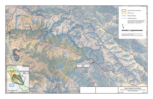
Upper <strong>Alameda</strong> <strong>Creek</strong> BasinSFPUC LandPerennial StreamIntermittent Stream<strong>Alameda</strong> <strong>Creek</strong><strong>Diversion</strong> <strong>Dam</strong>Camp OhloneWhitlock <strong>Creek</strong>Bear GulchNote: Stream-type design<strong>at</strong>ion based on symbologyshown on the USGS 7.5-minute quadrangles forCalaveras Reservoir, La Costa Valley, Mount Day,Mendenhall Springs, and Eylar Mountain.0 0.51 2MILESLittle YosemiteImagery source: USDA N<strong>at</strong>ional Agriculture Imagery Program,Santa Clara County mosaic, 2005Hydrography d<strong>at</strong>a source: USGS N<strong>at</strong>ional Hydrography D<strong>at</strong>aset<strong>Alameda</strong> Cre ekL:\Projects\Calaveras_<strong>Dam</strong>_26814408\Mxd\Current Working Documents\Biology\<strong>Fish</strong>_passage_study\ACDD\<strong>Fish</strong>_passage_ACDD_Fig6-1_UAC_Basin.mxdURS Corp-Oakland, CA-C.RaumannCalaverasReservoirUpper <strong>Alameda</strong> <strong>Creek</strong>Sub-W<strong>at</strong>ershedSFPUCLandCalaverasReservoir0 5 10MILEEXTENT OF DETAILOVERVIEWUpper <strong>Alameda</strong> <strong>Creek</strong>BasinUpper <strong>Alameda</strong> <strong>Creek</strong>BasinUpper <strong>Alameda</strong> <strong>Creek</strong> Basin<strong>Feasibility</strong> <strong>of</strong> <strong>Fish</strong> <strong>Passage</strong> <strong>at</strong> <strong>Alameda</strong> <strong>Creek</strong> <strong>Diversion</strong> <strong>Dam</strong>Technical MemorandumJune 2009Figure 6-1