- Page 1:
Northern San Luis Obispo County Coa
- Page 5 and 6:
Acknowledgements San Luis Obispo Co
- Page 7 and 8:
Table of Contents Table of Contents
- Page 9 and 10:
Table of Contents E.3. Biological R
- Page 11 and 12:
Table of Contents Figure 4-40: Pico
- Page 13 and 14:
1. Introduction and Summary Introdu
- Page 15 and 16:
Introduction and Summary Objective
- Page 17 and 18:
Introduction and Summary people enj
- Page 19 and 20:
Introduction and Summary want to av
- Page 21 and 22:
Figure 1-1: California Coastal Trai
- Page 23 and 24:
Segment 3 -San Simeon Point to Camb
- Page 25 and 26:
Segment 6 - Estero Bluffs and Cayuc
- Page 27 and 28:
Introduction and Summary landscape.
- Page 29 and 30:
Figure 1-2: Segment 1 Recommended I
- Page 31 and 32:
3. 4 trail bridges - 35 to 95 feet
- Page 33 and 34:
Segment 3: Broken Creek Bridge to H
- Page 35 and 36:
Figure 1-4: Segment 3 Recommended I
- Page 37 and 38:
Figure 1-5: Segment 4 Recommended I
- Page 39 and 40:
Figure 1-6: Segment 5 Recommended I
- Page 41 and 42:
Figure 1-7: Segment 6 Recommended I
- Page 43 and 44:
1.8.3. Implementation Strategy Summ
- Page 45 and 46:
Introduction and Summary Addressing
- Page 47 and 48:
2. Setting Setting Chapter 2 provid
- Page 49 and 50:
Setting Land Use Summary Table Tabl
- Page 51 and 52:
Figure 2-2: North Coast Area Combin
- Page 53 and 54:
2.1.1. Existing Attractions and Des
- Page 55 and 56:
A matrix of existing recreational a
- Page 57 and 58:
Setting Figure 2-4, reproduced from
- Page 59 and 60:
Setting Through the West Side Publi
- Page 61 and 62:
PM Location Size Amenities 38.6 50'
- Page 63 and 64:
Setting West Fiscalini Ranch Preser
- Page 65 and 66:
Setting best dry-range areas. The m
- Page 67 and 68: Setting Habitat Type General Constr
- Page 69 and 70: Setting associated with unauthorize
- Page 71 and 72: Setting are an abundance of afforda
- Page 73 and 74: Figure 2-5: Tourist Serving Ameniti
- Page 75 and 76: 3. Design Standards and Guidelines
- Page 77 and 78: Design Guideline or Regulation Topi
- Page 79 and 80: Design Standards and Guidelines des
- Page 81 and 82: Design Standards and Guidelines whe
- Page 83 and 84: Design Standards and Guidelines The
- Page 85 and 86: Design Standards and Guidelines 1.
- Page 87 and 88: Design Standards and Guidelines cla
- Page 89 and 90: Design Standards and Guidelines Coa
- Page 91 and 92: Design Standards and Guidelines The
- Page 93 and 94: Design Standards and Guidelines pub
- Page 95 and 96: � Noise: OPDMDs shall not produce
- Page 97 and 98: Design Standards and Guidelines Por
- Page 99 and 100: Design Standards and Guidelines sid
- Page 101 and 102: 4 Master Plan Recommendations Maste
- Page 103 and 104: 4.2 Trail and Support Facility Type
- Page 105 and 106: Master Plan Recommendations Trails
- Page 107 and 108: Master Plan Recommendations unimpro
- Page 109 and 110: 4.2.5 Bridges and Drainage Crossing
- Page 111 and 112: Master Plan Recommendations can acc
- Page 113 and 114: Master Plan Recommendations roadway
- Page 115 and 116: Figure 4-6: Narrow Pedestrian Sidep
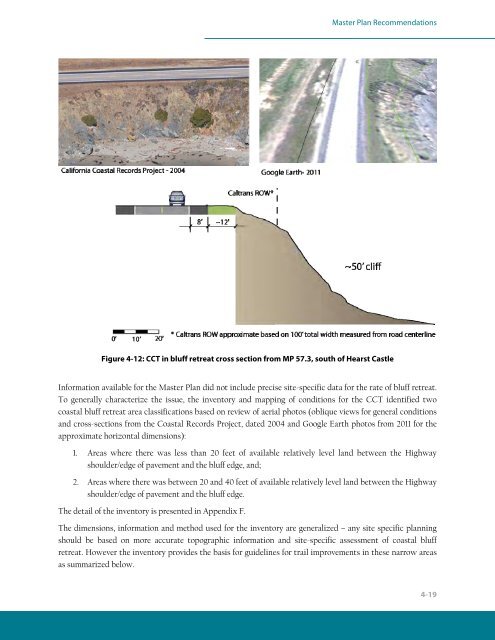
- Page 117: Master Plan Recommendations Figure
- Page 121 and 122: Master Plan Recommendations and des
- Page 123 and 124: Figure 4-13: An existing eight foot
- Page 125 and 126: Master Plan Recommendations Figure
- Page 127 and 128: Segment 1-1: County Line to Ragged
- Page 129 and 130: Figure 4-18: Segment 1-1 Recommenda
- Page 131 and 132: Segment 2: Ragged Point to to Broke
- Page 133 and 134: Master Plan Recommendations � Req
- Page 135 and 136: Figure 4-22: San Simeon Point Acces
- Page 137 and 138: Segment 2-2: Ragged Point to Arroyo
- Page 139 and 140: Figure 4-24: Segment 2-2 Recommenda
- Page 141 and 142: Master Plan Recommendations Segment
- Page 143 and 144: Master Plan Recommendations need to
- Page 145 and 146: Figure 4-28: Segment 2-3 Recommenda
- Page 147 and 148: Figure 4-29: Segment 2-4 Recommenda
- Page 149 and 150: Master Plan Recommendations protect
- Page 151 and 152: Segment 3: South Elephant Seal Boar
- Page 153 and 154: Master Plan Recommendations 100 fee
- Page 155 and 156: Figure 4-34: Segment 3-1 Recommenda
- Page 157 and 158: Figure 4-35: Segment 3-2 Recommenda
- Page 159 and 160: � Construct fencing to separate v
- Page 161 and 162: Master Plan Recommendations Drainag
- Page 163 and 164: Segment 3-3: Broken Bridge Creek to
- Page 165 and 166: Master Plan Recommendations If impr
- Page 167 and 168: Figure 4-40: Pico Cove Conservation
- Page 169 and 170:
Master Plan Recommendations Figure
- Page 171 and 172:
Segment 3-5: Hearst San Simeon Stat
- Page 173 and 174:
Figure 4-43: Segment 3-5 Recommenda
- Page 175 and 176:
Segment 4: Northern Cambria to Fisc
- Page 177 and 178:
Master Plan Recommendations Access
- Page 179 and 180:
Segment 4-2: Fiscalini Ranch Preser
- Page 181 and 182:
Figure 4-47: Segment 4-2 Recommenda
- Page 183 and 184:
Master Plan Recommendations sidepat
- Page 185 and 186:
Segment 5: Fiscalini Creek to Harmo
- Page 187 and 188:
Master Plan Recommendations the bea
- Page 189 and 190:
Master Plan Recommendations Segment
- Page 191 and 192:
Figure 4-51 : Segment 5-2 Recommend
- Page 193 and 194:
Segment 6-1: Estero Bluffs State Pa
- Page 195 and 196:
Figure 4-53: Segment 6-1 Recommenda
- Page 197 and 198:
Master Plan Recommendations Drainag
- Page 199 and 200:
Segment 6-3: Estero Bluffs State Pa
- Page 201 and 202:
Figure 4-55: Segment 6-3 Recommenda
- Page 203 and 204:
5. Action Plan Action Plan This Cha
- Page 205 and 206:
Action Plan resources, bluff retrea
- Page 207 and 208:
Implementation Steps: 1. Negotiatio
- Page 209 and 210:
2. Site survey - boundaries and top
- Page 211 and 212:
6. CA State Water Resources Board n
- Page 213 and 214:
7. CA Department of Fish and Game S
- Page 215 and 216:
Responsible Party: DPR � Facility
- Page 217 and 218:
2. Site survey - boundaries and top
- Page 219 and 220:
7. Construction and related service
- Page 221 and 222:
Segment 6-2 Estero Bluffs State Par
- Page 223 and 224:
Piedras Blancas Realignment Project
- Page 225 and 226:
San Simeon Point and Connections No
- Page 227 and 228:
Action Plan California Environmenta
- Page 229 and 230:
What work is required and what will
- Page 231:
Item Estimated Frequency AC pavemen