Northern San Luis Obispo County Coastal Trail Master Plan
Northern San Luis Obispo County Coastal Trail Master Plan
Northern San Luis Obispo County Coastal Trail Master Plan

Create successful ePaper yourself
Turn your PDF publications into a flip-book with our unique Google optimized e-Paper software.
<strong>Northern</strong> <strong>San</strong> <strong>Luis</strong> <strong>Obispo</strong> <strong>County</strong> <strong>Coastal</strong> <strong>Trail</strong> <strong>Master</strong> <strong>Plan</strong><br />
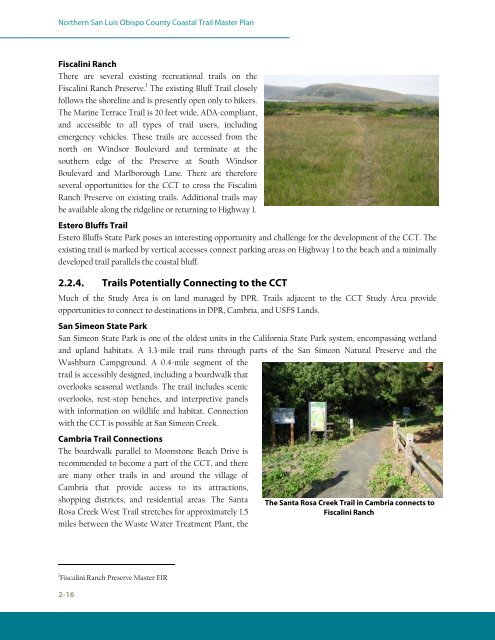
Fiscalini Ranch<br />
There are several existing recreational trails on the<br />
Fiscalini Ranch Preserve. 1 The existing Bluff <strong>Trail</strong> closely<br />
follows the shoreline and is presently open only to hikers.<br />
The Marine Terrace <strong>Trail</strong> is 20 feet wide, ADA-compliant,<br />
and accessible to all types of trail users, including<br />
emergency vehicles. These trails are accessed from the<br />
north on Windsor Boulevard and terminate at the<br />
southern edge of the Preserve at South Windsor<br />
Boulevard and Marlborough Lane. There are therefore<br />
several opportunities for the CCT to cross the Fiscalini<br />
Ranch Preserve on existing trails. Additional trails may<br />
be available along the ridgeline or returning to Highway 1.<br />
Estero Bluffs <strong>Trail</strong><br />
Estero Bluffs State Park poses an interesting opportunity and challenge for the development of the CCT. The<br />
existing trail is marked by vertical accesses connect parking areas on Highway 1 to the beach and a minimally<br />
developed trail parallels the coastal bluff.<br />
2.2.4. <strong>Trail</strong>s Potentially Connecting to the CCT<br />
Much of the Study Area is on land managed by DPR. <strong>Trail</strong>s adjacent to the CCT Study Area provide<br />
opportunities to connect to destinations in DPR, Cambria, and USFS Lands.<br />
<strong>San</strong> Simeon State Park<br />
<strong>San</strong> Simeon State Park is one of the oldest units in the California State Park system, encompassing wetland<br />
and upland habitats. A 3.3-mile trail runs through parts of the <strong>San</strong> Simeon Natural Preserve and the<br />
Washburn Campground. A 0.4-mile segment of the<br />
trail is accessibly designed, including a boardwalk that<br />
overlooks seasonal wetlands. The trail includes scenic<br />
overlooks, rest-stop benches, and interpretive panels<br />
with information on wildlife and habitat. Connection<br />
with the CCT is possible at <strong>San</strong> Simeon Creek.<br />
Cambria <strong>Trail</strong> Connections<br />
The boardwalk parallel to Moonstone Beach Drive is<br />
recommended to become a part of the CCT, and there<br />
are many other trails in and around the village of<br />
Cambria that provide access to its attractions,<br />
shopping districts, and residential areas. The <strong>San</strong>ta<br />
Rosa Creek West <strong>Trail</strong> stretches for approximately 1.5<br />
miles between the Waste Water Treatment <strong>Plan</strong>t, the<br />
1 Fiscalini Ranch Preserve <strong>Master</strong> EIR<br />
2-16<br />
The <strong>San</strong>ta Rosa Creek <strong>Trail</strong> in Cambria connects to<br />
Fiscalini Ranch