Northern San Luis Obispo County Coastal Trail Master Plan
Northern San Luis Obispo County Coastal Trail Master Plan
Northern San Luis Obispo County Coastal Trail Master Plan

Create successful ePaper yourself
Turn your PDF publications into a flip-book with our unique Google optimized e-Paper software.
Setting<br />
West Fiscalini Ranch Preserve, and Highway 1. <strong>Trail</strong>s cross Highway 1 along <strong>San</strong>ta Rosa Creek, through the<br />
East Fiscalini Ranch Preserve, continuing to <strong>San</strong>ta Lucia Middle School. Strawberry Canyon Park in Cambria<br />
also provides a short hiking trail.<br />
Harmony Headlands State Park<br />
Located in Harmony Headlands State Park, the one-mile Headlands <strong>Trail</strong> is signed with the CCT insignia and<br />
will provide vertical access to the beach from the likely trail corridor along Highway 1.<br />
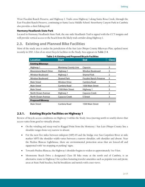
2.3. Existing and <strong>Plan</strong>ned Bike Facilities<br />
Most of the study area is under the jurisdiction of the <strong>San</strong> <strong>Luis</strong> <strong>Obispo</strong> <strong>County</strong> Bikeways <strong>Plan</strong>, updated most<br />
recently in 2010. A list of on-street bicycle facilities in the Study Area appears in Table 2-4.<br />
Table 2-4: Existing and Proposed Bicycle Facilities<br />
Location<br />
Existing Bikeways<br />
Start End Class<br />
Highway 1 Monterey <strong>County</strong> Line Cayucos 3<br />
Moonstone Beach Drive Highway 1 Windsor Boulevard 3<br />
Windsor Boulevard Highway 1 Shamel Park 2<br />
Windsor Boulevard Shamel Park Fiscalini Ranch Preserve 3<br />
Main Street Windsor Drive Cambria Road 3<br />
Main Street Cambria Road 1500 Main Street 2<br />
Main Street 1500 Main Street Highway 1 3<br />
North Ocean Avenue Highway 1 Cayucos Creek 2<br />
North Ocean Avenue<br />
Proposed Bikeway<br />
Cayucos Creek E Street 3<br />
Main Street Cambria Road 1500 Main Street 2<br />
2.3.1. Existing Bicycle Facilities on Highway 1<br />
Review of bicycle access conditions on Highway 1 within the Study Area (moving north to south) shows that<br />
access varies from good to virtually absent:<br />
� On the winding and steep road to Ragged Point from the Monterey / <strong>San</strong> <strong>Luis</strong> <strong>Obispo</strong> <strong>County</strong> line a<br />
shoulder ranges from very narrow to absent.<br />
� For the next five miles between milepost (MP) 65 and the bridge over <strong>San</strong> Carpoforo River at mile<br />
marker MP71 the shoulder width varies between a narrow shoulder, soft shoulder and absent. Near<br />
the Piedras Blancas Lighthouse, there are environmental protection areas that are fenced-off and<br />
signposted with “no stopping or parking” signs.<br />
� Towards Piedras Blancas, the Highway 1 shoulder begins to widen to approximately 3 to 5 feet.<br />
� Moonstone Beach Drive a designated Class III bike route at the north end of Cambria, is an<br />
alternative route to Highway 1 for cyclists featuring traveler amenities such as popular rest and picnic<br />
areas at State Park beaches, bed & breakfasts and motels with coast views.<br />
2-17