Northern San Luis Obispo County Coastal Trail Master Plan
Northern San Luis Obispo County Coastal Trail Master Plan
Northern San Luis Obispo County Coastal Trail Master Plan

You also want an ePaper? Increase the reach of your titles
YUMPU automatically turns print PDFs into web optimized ePapers that Google loves.
<strong>Northern</strong> <strong>San</strong> <strong>Luis</strong> <strong>Obispo</strong> <strong>County</strong> <strong>Coastal</strong> <strong>Trail</strong> <strong>Master</strong> <strong>Plan</strong><br />
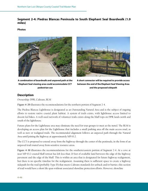
Segment 2-4: Piedras Blancas Peninsula to South Elephant Seal Boardwalk (1.9<br />
miles)<br />
Photos<br />
A combination of boardwalk and unpaved path at the<br />
Elephant Seal viewing area could accommodate CCT<br />
pedestrian use<br />
Description<br />
Ownership: DPR, Caltrans, BLM<br />
Figure 4-29 illustrates the recommendations for the northern portion of Segment 2-4.<br />
The Piedras Blancas Lighthouse is designated as an Outstanding Natural Area and is the subject of ongoing<br />
efforts to restore native coastal plant habitat. A system of trails exists, with lighthouse access limited to<br />
docent-led hikes. A well-used network of volunteer trails exists along the bluff tops on DPR lands north and<br />
south of the lighthouse.<br />
Future plans for the Lighthouse area may eliminate the need for tour groups to meet at the motel. The BLM is<br />
developing an access plan for the Lighthouse that includes a small parking area off the main access road, as<br />
well as new or realigned trails. The recommended alignment follows an unpaved path through the Natural<br />
Area until joining the highway at approximately MP 63.2.<br />
The CCT is proposed to extend away from the highway through the center of the peninsula, in the form of an<br />
unpaved trail routed away from sensitive resource areas.<br />
Figure 4-30 illustrates the recommendations for the southern/eastern portion of Segment 2-4. At a cove at<br />
near MP 63.2 coastal bluff retreat has left less than 20 feet of available land between the edge of the highway<br />
pavement and the edge of the bluff. This is within an area that is designated for future highway realignment,<br />
but there is no specific timeline for the realignment. Assuming there is sufficient space to create a highway<br />
sidepath for the trail (probably Type D) that meets Caltrans standards for setback and/or barrier, this section<br />
of trail would have a short life span without associated shoreline protection efforts. However, shoreline<br />
4-46<br />
A short connector will be required to provide access<br />
between the end of the Elephant Seal Viewing Area<br />
and the proposed sidepath