Northern San Luis Obispo County Coastal Trail Master Plan
Northern San Luis Obispo County Coastal Trail Master Plan
Northern San Luis Obispo County Coastal Trail Master Plan

You also want an ePaper? Increase the reach of your titles
YUMPU automatically turns print PDFs into web optimized ePapers that Google loves.
<strong>Northern</strong> <strong>San</strong> <strong>Luis</strong> <strong>Obispo</strong> <strong>County</strong> <strong>Coastal</strong> <strong>Trail</strong> <strong>Master</strong> <strong>Plan</strong><br />
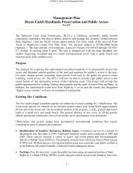
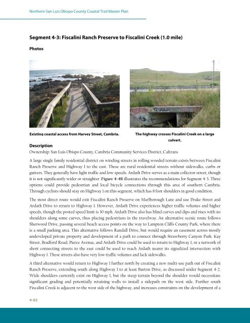
Segment 4-3: Fiscalini Ranch Preserve to Fiscalini Creek (1.0 mile)<br />
Photos<br />
Existing coastal access from Harvey Street, Cambria.<br />
culvert.<br />
Description<br />
Ownership: <strong>San</strong> <strong>Luis</strong> <strong>Obispo</strong> <strong>County</strong>, Cambria Community Services District, Caltrans<br />
A large single family residential district on winding streets in rolling wooded terrain exists between Fiscalini<br />
Ranch Preserve and Highway 1 to the east. These are rural residential streets without sidewalks, curbs or<br />
gutters. They generally have light traffic and low speeds. Ardath Drive serves as a main collector street, though<br />
it is not significantly wider or straighter. Figure 4-48 illustrates the recommendations for Segment 4-3. Three<br />
options could provide pedestrian and local bicycle connections through this area of southern Cambria.<br />
Through cyclists should stay on Highway 1 on this segment, which has 8 foot shoulders in good condition.<br />
The most direct route would exit Fiscalini Ranch Preserve on Marlborough Lane and use Drake Street and<br />
Ardath Drive to return to Highway 1. However, Ardath Drive experiences higher traffic volumes and higher<br />
speeds, though the posted speed limit is 30 mph. Ardath Drive also has blind curves and dips and rises with no<br />
shoulders along some curves, thus placing pedestrians in the travelway. An alternative scenic route follows<br />
Sherwood Drive, passing several beach access points on the way to Lampton Cliffs <strong>County</strong> Park, where there<br />
is a small parking area. This alternative follows Randall Drive, but would require an easement across mostly<br />
undeveloped private property and development of a path to connect through Strawberry Canyon Park. Kay<br />
Street, Bradford Road, Pierce Avenue, and Ardath Drive could be used to return to Highway 1, or a network of<br />
short connecting streets to the east could be used to reach Ardath nearer its signalized intersection with<br />
Highway 1. These streets also have very low traffic volumes and lack sidewalks.<br />
A third alternative would return to Highway 1 further north by creating a new multi-use path out of Fiscalini<br />
Ranch Preserve, extending south along Highway 1 to at least Burton Drive, as discussed under Segment 4-2.<br />
Wide shoulders currently exist on Highway 1, but the steep terrain beyond the shoulder would necessitate<br />
significant grading and potentially retaining walls to install a sidepath on the west side. Further south<br />
Fiscalini Creek is adjacent to the west side of the highway, and increases constraints on the development of a<br />
4-82<br />
The highway crosses Fiscalini Creek on a large