Local Planning Policy Framework - Moreland City Council
Local Planning Policy Framework - Moreland City Council
Local Planning Policy Framework - Moreland City Council

You also want an ePaper? Increase the reach of your titles
YUMPU automatically turns print PDFs into web optimized ePapers that Google loves.
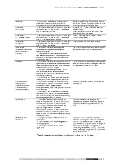
Business 3 To encourage the integrated development of<br />
offices and manufacturing industries and<br />
associated commercial and light industrial uses.<br />
Public Use 2<br />
(Education)<br />
Public Use 6<br />
(<strong>Local</strong> Government)<br />
Public Use 4<br />
(Transport)<br />
Special Use 2<br />
(Places of Worship and<br />
Private Education<br />
Centres)<br />
To recognise public land use for public utility and<br />
community services and facilities; in this case,<br />
use for education purposes<br />
To recognise public land use for public utility and<br />
community services and facilities; in this case,<br />
use for local government purposes.<br />
To recognise public land use for public utility and<br />
community services and facilities; in this case,<br />
use for transport purposes.<br />
To provide for educational and religious<br />
institutions and associated facilities in a<br />
landscaped setting.<br />
To integrate the use and development of the<br />
land with redevelopment of the Pentridge Prison<br />
site and Civic precinct and to retain the public<br />
nature of the precinct.<br />
Industrial 3 To provide for industries and associated uses in<br />
specific areas where special consideration of the<br />
nature and impacts of industrial uses is required<br />
or to avoid inter-industry conflict.<br />
To provide a buffer between the IN1Z or IN2Z<br />
and local communities, which allows for<br />
industries and associated uses compatible with<br />
the nearby community.<br />
To ensure that uses do not affect the safety or<br />
amenity of adjacent, more sensitive land uses.<br />
Comprenhensive<br />
Development 1<br />
(Grandview Square<br />
Comprenhensive<br />
Development Plan)<br />
To provide for the integrated subdivision and<br />
development of the land in accordance with the<br />
Grandview Square Comprehensive<br />
Development Plan, April 1999, prepared by Tract<br />
Consultants P/L.<br />
To provide for a mix of residential, tourist and<br />
commercial uses that can be integrate the site<br />
with the surrounding uses whilst complementing<br />
the heritage significance of the site.<br />
Residential 1 To provide for residential development at a<br />
range of densities with a variety of dwellings to<br />
meet the housing needs of all households.<br />
To encourage residential development that<br />
respects neighbourhood character.<br />
In appropriate locations, to allow educational,<br />
recreational, religious, community and a limited<br />
range of other non-residential uses to serve local<br />
community needs.<br />
Public Park and<br />
Recreation<br />
To recognise areas for public recreation and<br />
open space.<br />
To protect and conserve areas of significance<br />
where appropriate.<br />
To provide for commercial uses where<br />
appropriate.<br />
Central Coburg 2020 Background Report [ PHASE 1: Research and Analysis ]<br />
Business area fronting Sydney Road south of<br />
Munro and Harding Streets, consisting of a mix<br />
of shops and other commercial uses.<br />
<strong>Moreland</strong> <strong>City</strong> College to the east, adjoining<br />
the Merri Creek.<br />
Coburg Primary School on Bell Street, split<br />
between the north and south<br />
Coburg Town Hall and <strong>Moreland</strong> <strong>Council</strong><br />
Offices on Bell Street.<br />
Coburg Station and the Upfield rail line.<br />
The church precinct n the north east corner of<br />
the Sydney Road – Bell Street intersection.<br />
Transitional area of old industrial buildings like<br />
the CDA Veloura factory, fronting the west side<br />
of Sydney Road, north of Bell Street.<br />
Generally covers the heritage area within the<br />
Pentridge site.<br />
Generally standard suburban post war<br />
residential development, consisting largely of<br />
single detached housing and some flats and<br />
units.<br />
Covers the Merri Creek and associated<br />
reserves – Coburg Lake Reserve, De Chene<br />
Reserve; McDonald Reserve east of the<br />
<strong>Council</strong> Offices; Bridges Reserve fronting Bell<br />
Street and including the Coburg Leisure<br />
Centre, <strong>City</strong> Oval and the Bowling Club; and a<br />
number of smaller neighbourhood parks within<br />
the residential areas.<br />
Figure 2 shows the current planning scheme zones that exist in the area.<br />
15