

Discussion Paper - Part A - Victorian Environmental Assessment ...
Discussion Paper - Part A - Victorian Environmental Assessment ...
Discussion Paper - Part A - Victorian Environmental Assessment ...
- No tags were found...

Create successful ePaper yourself
Turn your PDF publications into a flip-book with our unique Google optimized e-Paper software.
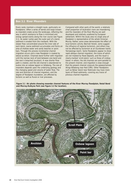
Box 3.1 River MeandersRivers rarely maintain a straight route, particularly onfloodplains. Often a series of bends and loops knownas meanders snake across the landscape, reflecting theway in which resistance to flow is minimised andenergy spread evenly along the river course (see Figure3.1). As water rushes past the outer part of a bend,sediment is eroded from the riverbank. With theslower flow concentrated around the inner side ofeach bend, coarse sediment accumulates and forms anarea of shallow water and sandy beaches or pointbars. Through this process incremental channelmigration occurs and a new floodplain is created bylateral accretion. Channels bend further with migrationuntil the narrow neck of land between one bend andthe next is breached (avulsion). A new shorter flowpath is created, and the old channel is abandoned toevolve into an oxbow lagoon or billabong. The size ofmeanders depends upon the underlying geology andthe changing speed and volume of water flow. Therate and direction of channel migration, and thedegree of floodplain inundation, are affected bytectonic as well as fluvial or river processes.Compared with other parts of the world, a relativelysmall proportion of Australia’s rivers are meandering,and the meanders of the River Murray are welldeveloped and relatively unaltered by Europeansettlement. Within the study area no single area offloodplain is representative of the whole <strong>Victorian</strong>Murray. Rather, some areas demonstrate the effect oflocal tectonic activity (Barmah forest), some suggestthe influence of regional tectonism, and others maynot be affected by tectonism at all (Gunbower Island,Yarrawonga reach). Some floodplains appear to showrapid oblique channel migration, the traces of whichare not masked by flood deposits, and the result isclearly-marked ‘scroll plains’ such as those of LindsayIsland. In others, the old channels are semi-parallel tothe present channel, and migration is slow enoughthat the present channel crosscuts the palaeochannels(Kings Billabong near Red Cliffs). Other floodplainssuch as Belsar Island near Robinvale may have morelayers of flood sediments, covering any traces ofprevious channel migration.Figure 3.1 Air photo showing meander channel features of the River Murray floodplain, Retail Bendand Murray-Kulkyne Park (see Figure 3.2 for location).Scroll PlainAvulsionOxbow lagoonPoint bar20 River Red Gum Forests Investigation 2006


