change from saline lakes and clay lunette formation tofreshwater conditions, as recorded by the presence offreshwater fauna in local midden deposits. Dating of theNorthern Riverine Plain landforms has unravelled muchof the Late Quaternary climatic history and processes inthis region.Downstream of Hattah the remaining area of theNorthern Riverine Plains is represented as an entrenchedand more constrained river system containing diverselandforms including anabranches that form large islandssuch as Lindsay, Wallpolla and Mulcra Islands, as well asmeander channels, billabongs, levees and low dunes,with larger overflow lakes and lunettes abutting thesemi-arid Mallee region. The area consists of three maingeomorphological components: the riverine floodplain(subject to periodic flooding and encompassingnumerous oxbow lakes, ephemeral wetlands and activemeander belts); broad, flat alluvial plains (infrequentlyflooded); and alluvial rises or elevated terrace areas thatwere built up during more arid periods by wind-blownmaterial from the surrounding areas. To the south andflanking the floodplains, lie the North West Dunefieldsand Plains.North West Dunefields and PlainsThe North West Dunefields and Plains extend north fromthe edge of the Western Uplands to the margin of theNorthern Riverine Plain. In the study area, it occurs onlyin small peripheral patches west and north of Kerang(Map 3.1). This geomorphological region consists largelyof dry, sandy, gently undulating plains with extensivesiliceous and calcareous dunefields, becoming moresubdued towards the south. Beneath the plains is a lowrelief bedrock surface, only rarely rising above the plainsas low granitic hills (such as at Wycheproof). Rivers inthe region, such as the Avoca and Wimmera, rise in theWestern Uplands to the south, lose water byevaporation and infiltration as they flow northwards,and do not reach the Murray. Elsewhere across much ofthe North West Dunefields and Plains there is almost norun-off, except locally after heavy rain. The rivers arelinear and relatively fixed, showing little evidence ofmigration, and are flanked by floodplain and terracedeposits of Pleistocene and Holocene age. Low-lyingareas contain saline lake complexes, or freshwater lakesfed by the rivers (e.g. Raak Plain, Avoca Marshes). Clayplains, cemented in places by calcrete, underlie largeparts of the dunefields, and salt lakes in the north of theregion. Beneath the dune and lake sediments are thecurvilinear coastal ridges of the Pliocene Parilla Sands.There were several separate phases of dune activitycomprising siliceous and calcareous dune complexes. Asiliceous (Lowan Sand) dunefield (Sunset Country) lies tothe south and west of the riverine plain in northwestVictoria and contains both linear and parabolic dunes.The parabolic dunes are often large, with sharp crests,and interspersed with wide sandplains and smaller, oftensmooth-crested, dunes of variable orientation. The lineardunes are closely-spaced, low and smooth-crested, withnarrow, sandy swales. Dunes of both types are orientedeast-west to northeast-southwest, parallel to the presentdominant wind directions.The calcareous dunefield forms a large area of theMallee extending discontinuously from Nhill northeast tothe Northern Riverine Plain, and includes reddish quartzsands (Woorinen Formation). These dunes are vegetated,predominantly linear and oriented east-west, but are notuniformly distributed. In the west quartz sand andcarbonate dominate, but in the east, where the duneshave migrated over the clay-rich riverine plain, up to 20percent clay content is common.These calcareous dunes and associated palaeosols reflectthe alternation of cool and arid conditions with wettersoil forming conditions. The siliceous dunes of theLowan Sand have a notable absence of clay andcarbonate in contrast to the Woorinen Formation dunes.Large, variably saline lake complexes occupy low areas,such as the Kerang Lakes and the Raak Plain adjoiningthe study area. These saline lakes are groundwaterdischarge basins or relict groundwater dischargefeatures, where saline groundwater can emerge and,through intense evaporation, produce hypersaline brines.Sediment is deposited by aeolian input and precipitationfrom groundwater; typically lake floor sediments aredominated by gypsum.The freshwater lakes differ from the saline lakes in thatthey contain fluvial or river sediment and have welldefinedelliptical or rounded margins. The eastern sidesof most of the lakes have low half-moon-shaped lunettedunes of sand and gypseous silt. Orientation of theselunettes indicates that westerly wind regimes wereresponsible for their formation, which are thought tohave dominated during arid dune-building phases of thePleistocene.Eastern UplandsThe River Red Gum Forests study area extends along theKing, Kiewa and Ovens rivers into small areas on thenorthern slopes of the Eastern Uplands (Map 3.1). TheEastern Uplands form part of the broader Great DividingRange, and are the largest and highest upland areas ofVictoria. The region can be divided into two broad areas:the gentler topography of the high plains and the deeplyincised valleys of the northern and southern slopes,including some low plateaus.The northern slopes of the Eastern Uplands consist ofsteep-sided branching river valleys with thick sediment,separated by high, narrow ridges with mostly young,stony gradational soils caused by the continualmovement of weathered material down the slopes. Rivergradients within the dissected northern slopes are steep,particularly in the upper reaches, but gradually decreaseas the valleys widen downstream and enter the studyarea. River direction is often determined by pastgeological activity, for example, the Kiewa River followsthe north-northwest line of the Kiewa Fault. Thesenorthern rivers flow either across the Riverine Plains tojoin the Murray River (Goulburn, King and Ovens Rivers)or, east of Wodonga, into the Murray directly (Indi (orUpper Murray), Mitta Mitta and Kiewa Rivers).The lower parts of the river valleys of the northernmargin are partially filled with alluvium and have openU-shaped or sometimes angled cross-sections. Thealluvial flats are often flooded during late winter andspring in areas where snowmelt contributes to streams.Well-developed alluvial fan aprons have been depositedby ephemeral streams draining the sides of some of the<strong>Discussion</strong> <strong>Paper</strong>23
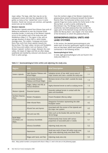
major valleys. The large, older fans may be cut bysubsequent erosion and new fans deposited in thegullies; as many as four ‘nested fans’ occur in somelocations. Paired river terraces are common, and typicallyseveral sets can be identified.Western UplandsThe Western Uplands extend from Kilmore Gap north ofMelbourne westwards to near the <strong>Victorian</strong>-SouthAustralian border. A small area of the Western Uplandsoccurs in the southern part of the study area nearWedderburn (Map 3.1). The region is low, with anaverage elevation of about 300 m, which dividesdrainage areas. The Loddon, Campaspe and AvocaRivers flow north from these uplands towards theMurray River. The major valleys, terraces and floodplainsof the Avoca and Loddon rivers are features of theWestern Uplands’ northern margin. Between the mainvalleys, the slopes of ridges and hills are often deeplyweathered and mantled by colluvium and alluvium, withfresh to saline springs.From the northern edges of the Western Uplands twopalaeosurfaces extend northwards beneath the NorthernRiverine Plain. The Karoonda Surface occurs on theuplands fringe but mostly overlies the Parilla Sands in theMurray Basin, as well as partly underlying theBlanchetown Clay. The Mologa Surface is a highlyweathered, low-relief palaeosurface that overlies theupper parts of the Renmark Group and Murray Groupwithin the Murray Basin—see chapter 2 for more detailsof the formations on which the palaeosurfaces lie.GEOMORPHOLOGICAL UNITS ANDLAND SYSTEMSIn this section, the detailed geomorphological unitswithin each of the four geomorphic regions of the studyarea are described, before land systems are brieflysummarised in the following section.Geomorphological UnitsIn total, eight geomorphological units are found in thestudy area (Table 3.1).Table 3.1 Geomorphological Units within and adjoining the study area.RegionUnitBrief DescriptionMapsymbolEastern UplandsHigh Elevation Plateaux andBroad RidgesSubalpine terrain of low relief; source area ofmajor streams and rivers—outside the study area1.1Intermediate ElevationPlateaux and Broad RidgesMontane terrain of low relief—outside the studyarea1.2Ridges, Valleys and Hills atVarious ElevationsHighly dissected terrain as well as outlying terrain1.3Western UplandsDissected UplandsGenerally subdued terrain in contact with theplains and dunefields2.1Northern RiverinePlainsModern FloodplainsPresent floodplain (Murray valley)4.1Older Alluvial PlainsShepparton Formation representing the olderfloodplain extent4.2Alluvial Fans and ApronsAssociated with the erosion of the Uplands andthe major river systems4.3Hills and Low HillsInliers such as the Dookie Hills and the TerrickTerrick Range4.4North WestDunefields andPlainsCalcareous DunefieldsPredominantly linear dunes with variousproportions of associated plain or swales5.1Siliceous DunefieldsAdjoining study area only5.2DepressionsSmall area north of Swan Hill within study area;larger areas adjoining study area (Raak Plain)5.3Ridges with Sand, and FlatsAdjoining study area only5.5Note : Map symbol numbers correspond with those in Map 3.1 and in the text on the following pages.24 River Red Gum Forests Investigation 2006