

Discussion Paper - Part A - Victorian Environmental Assessment ...
Discussion Paper - Part A - Victorian Environmental Assessment ...
Discussion Paper - Part A - Victorian Environmental Assessment ...
- No tags were found...

You also want an ePaper? Increase the reach of your titles
YUMPU automatically turns print PDFs into web optimized ePapers that Google loves.
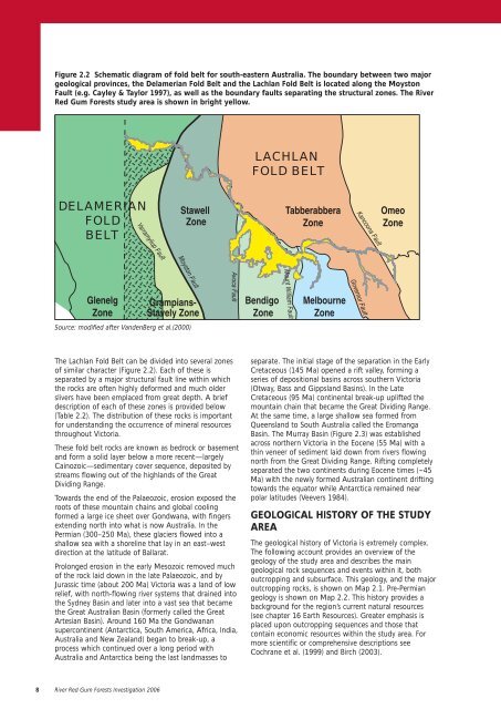
Figure 2.2 Schematic diagram of fold belt for south-eastern Australia. The boundary between two majorgeological provinces, the Delamerian Fold Belt and the Lachlan Fold Belt is located along the MoystonFault (e.g. Cayley & Taylor 1997), as well as the boundary faults separating the structural zones. The RiverRed Gum Forests study area is shown in bright yellow.LACHLANFOLD BELTDELAMERIANFOLDBELTYarramyliup FaultStawellZoneTabberabberaZoneKancoona FaultOmeoZoneGlenelgZoneMoyston FaultMount William FaultGrampians-Stavely ZoneAvoca FaultBendigoZoneMelbourneZoneGovernor FaultSource: modified after VandenBerg et al.(2000)The Lachlan Fold Belt can be divided into several zonesof similar character (Figure 2.2). Each of these isseparated by a major structural fault line within whichthe rocks are often highly deformed and much olderslivers have been emplaced from great depth. A briefdescription of each of these zones is provided below(Table 2.2). The distribution of these rocks is importantfor understanding the occurrence of mineral resourcesthroughout Victoria.These fold belt rocks are known as bedrock or basementand form a solid layer below a more recent—largelyCainozoic—sedimentary cover sequence, deposited bystreams flowing out of the highlands of the GreatDividing Range.Towards the end of the Palaeozoic, erosion exposed theroots of these mountain chains and global coolingformed a large ice sheet over Gondwana, with fingersextending north into what is now Australia. In thePermian (300–250 Ma), these glaciers flowed into ashallow sea with a shoreline that lay in an east–westdirection at the latitude of Ballarat.Prolonged erosion in the early Mesozoic removed muchof the rock laid down in the late Palaeozoic, and byJurassic time (about 200 Ma) Victoria was a land of lowrelief, with north-flowing river systems that drained intothe Sydney Basin and later into a vast sea that becamethe Great Australian Basin (formerly called the GreatArtesian Basin). Around 160 Ma the Gondwanansupercontinent (Antarctica, South America, Africa, India,Australia and New Zealand) began to break-up, aprocess which continued over a long period withAustralia and Antarctica being the last landmasses toseparate. The initial stage of the separation in the EarlyCretaceous (145 Ma) opened a rift valley, forming aseries of depositional basins across southern Victoria(Otway, Bass and Gippsland Basins). In the LateCretaceous (95 Ma) continental break-up uplifted themountain chain that became the Great Dividing Range.At the same time, a large shallow sea formed fromQueensland to South Australia called the EromangaBasin. The Murray Basin (Figure 2.3) was establishedacross northern Victoria in the Eocene (55 Ma) with athin veneer of sediment laid down from rivers flowingnorth from the Great Dividing Range. Rifting completelyseparated the two continents during Eocene times (~45Ma) with the newly formed Australian continent driftingtowards the equator while Antarctica remained nearpolar latitudes (Veevers 1984).GEOLOGICAL HISTORY OF THE STUDYAREAThe geological history of Victoria is extremely complex.The following account provides an overview of thegeology of the study area and describes the maingeological rock sequences and events within it, bothoutcropping and subsurface. This geology, and the majoroutcropping rocks, is shown on Map 2.1. Pre-Permiangeology is shown on Map 2.2. This history provides abackground for the region’s current natural resources(see chapter 16 Earth Resources). Greater emphasis isplaced upon outcropping sequences and those thatcontain economic resources within the study area. Formore scientific or comprehensive descriptions seeCochrane et al. (1999) and Birch (2003).8 River Red Gum Forests Investigation 2006


