Discussion Paper - Part A - Victorian Environmental Assessment ...
Discussion Paper - Part A - Victorian Environmental Assessment ...
Discussion Paper - Part A - Victorian Environmental Assessment ...
- No tags were found...
Create successful ePaper yourself
Turn your PDF publications into a flip-book with our unique Google optimized e-Paper software.
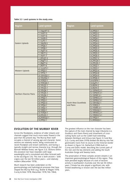
Table 3.3 Land systems in the study area.RegionLand systemRegionLand systemEastern UplandsWestern UplandsNorthern Riverine Plains1.1HgmP7-31.1HsP7-51.1HsP7-61.1HsP8-51.1LsP5-11.1MsP8-51.1PfQ6-11.1PfQ8-11.1PgP7-41.1RbT7-21.1RsP7-71.3FfcQ7-21.3HgP7-31.3RgP7-41.3RsP7-62.1LmsP3-12.1PfQ3-12.1PfT4-74.1DPcfQ2-14.1FDcfQ2-14.1FSfQ3-14.1FSfcQ4-14.1FfcQ2-14.1FfcQ3-14.1FfcQ4-14.1FfcQ5-14.1FfcQ6-14.1PfQ2-14.1PfQ3-14.1PfQ3-34.1PfQ4-14.1SfQ2-14.1SfQ3-14.1FSfQ4-14.2FfcQ3-14.2PDfcQ2-14.2PfQ2-1North West Dunefieldsand Plains4.2PfQ3-14.2PfQ3-24.2PfQ3-34.2PfQ4-14.2PfQ4-24.2PfQ4-54.2PfQ4-64.2PfQ5-34.2PfQ5-44.2PfQ5-54.2PfQ6-54.2PfQ7-24.2PfcQ4-14.2PfcQ5-14.2SfQ2-14.2SfQ3-14.3PfQ3-44.3PfQ4-84.3PfQ4-94.3PfQ6-34.4LfbP4-14.4LgP3-14.4RsP4-24.4RsP4-55.1DPRcfC2-15.1DPRcfC3-15.1DPRfC3-15.1DPRfcC2-15.1DPRfcC3-15.1DPcfQ2-15.1FSfQ3-15.1PDRfC3-15.1PDfcQ2-15.1RPDfcC2-15.1PRDfcC3-15.1PfQ3-15.3PDfzQ3-1EVOLUTION OF THE MURRAY RIVERAcross the floodplains, evidence of older streams andchannels suggest that much more water flowed in thepast than the present day. The Murray River itselfoccupies a channel of varying age and character. Somesections are relatively recent, being constructed onrecent floodplain and stream sediments, and having atypically straight and narrow character (e.g. through theBarmah–Millewa forest; see Figure 3.3). Sections withinthe ancestral river have meanders with largewavelengths and a convoluted and often tortured pathto the sea (Figure 3.4). This river is both ancient— withorigins over the last 50 million years— and relativelymodern (Macumber 1978).Much research has been undertaken on thegeomorphology and hydrological processes that haveshaped the Murray River (e.g. Bowler & Magee 1978;Currey & Dole 1978; Macumber 1978; Pels 1964).The greatest influence on the river character has beenthe capture of the main channel by large tributaries (i.e.Goulburn and Ovens Rivers) and movements of crosscuttingfaults such as the Cadell Fault extendingbetween Deniliquin and Echuca (see Figure 3.3 and Box3.2). Currey and Dole (1978) divided the Murray into fivegeomorphic tracts from its source to the <strong>Victorian</strong> borderas shown in Figure 3.4. Rutherfurd (1990) built onCurrey and Dole’s model, describing the current path ofthe river and the key elements and adding the SouthAustralian Gorge and Swamp tracts.The preservation of these complex ancient streams is animportant geomorphological feature of this region. Theyhave persisted largely because of a lack of tectonicactivity in southeastern Australia over the last 30 millionyears. Climate has also played a significant role, withlimited weathering or erosion over the last few millionyears.28 River Red Gum Forests Investigation 2006


