

Discussion Paper - Part A - Victorian Environmental Assessment ...
Discussion Paper - Part A - Victorian Environmental Assessment ...
Discussion Paper - Part A - Victorian Environmental Assessment ...
- No tags were found...

Create successful ePaper yourself
Turn your PDF publications into a flip-book with our unique Google optimized e-Paper software.
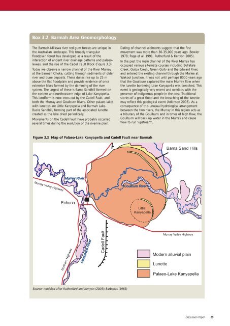
Box 3.2 Barmah Area GeomorphologyThe Barmah-Millewa river red gum forests are unique inthe Australian landscape. This broadly triangularfloodplain forest has developed as a result of theinteraction of ancient river drainage patterns and palaeolevees,and the rise of the Cadell Fault Block (Figure 3.3).Today we observe a narrow channel of the River Murrayat the Barmah Choke, cutting through sediments of olderriver and dune deposits. These dunes rise up to 25 mabove the flat floodplain and provide evidence of onceextensive lakes formed by the damming of the riversystem. The largest of these is Bama Sandhill formed onthe eastern and northeastern edge of Lake Kanyapella.This landform is now cross-cut by the Cadell Fault, andboth the Murray and Goulburn Rivers. Other palaeo-lakeswith lunettes are Little Kanyapella and Barmah Lake-Bucks Sandhill, forming part of the associated lunettecreated as the lake dried periodically.Movements on the Cadell Fault have probably occurredseveral times during the evolution of the riverine plain.Dating of channel sediments suggest that the firstmovement was more than 30-35,000 years ago (Bowler1978; Page et al. 1991; Rutherfurd & Kenyon 2005).In the past the main channel of the River Murray hasoccupied various alternate courses including BullataleCreek, Gulpa Creek, Green Gully and the Edward River,and entered the existing channel through the Mallee atWakool Junction. It was not until perhaps 8000 years agothat the Goulburn captured the main Murray flow whenthe lunette bordering Lake Kanyapella was breached. Thisevent is geologically very recent and overlaps with thepresence of Indigenous people in the area. Traditionalstories of a great flood and the breaching of the lunettemay reflect this geological event (Atkinson 2005). As aconsequence of this unusual hydrological arrangementbetween the two rivers, the Murray in this region acts asa tributary of the Goulburn and in times of high flow, theGoulburn will back up water in the Murray and causeflow to run ‘upstream’.Figure 3.3 Map of Palaeo-Lake Kanyapella and Cadell Fault near BarmahBama Sand HillsMurray RiverMurray Valley HighwayGoulburn RiverEchucaLittleKanyapellaNorthern HighwayCampaspe RiverCadell FaultMurray Valley HighwayModern alluvial plainLunettePalaeo-Lake KanyapellaSource: modified after Rutherfurd and Kenyon (2005); Barberias (1983)<strong>Discussion</strong> <strong>Paper</strong>29


