

Discussion Paper - Part A - Victorian Environmental Assessment ...
Discussion Paper - Part A - Victorian Environmental Assessment ...
Discussion Paper - Part A - Victorian Environmental Assessment ...
- No tags were found...

You also want an ePaper? Increase the reach of your titles
YUMPU automatically turns print PDFs into web optimized ePapers that Google loves.
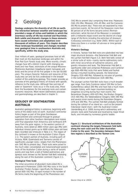
2 GeologyGeology underpins the diversity of all life on earth.The interaction between weather and landscape hasprovided a range of niches and habitats in which theenormous variety of life has evolved and flourished.Both subtle and dramatic changes in these elementshave caused extinctions and adaptations overthousands of millions of years. This chapter describesthese landscape foundations and changes recordedover geological time in southeastern Australia and,specifically, within the study area.Over millions of years, geological processes have all lefttheir mark on the Australian landscape and within theRiver Red Gum Forests study area. More recently, climaticchanges have left a distinct imprint with changing sealevels and river flows, extinctions of the unique Miocene-Pleistocene Australian megafauna (giant marsupials andbirds) and the arrival of the first people in the last 50,000years. The unique character, features and resources of thestudy area can only be fully understood in the broadercontext of the underlying geology. This chapter provides anoverview of the geological history of Victoria with specificreference to the study area. Although few outcrops ofolder or ‘basement’ rocks occur in the study area, theseform the foundations for the overlying rocks and containeconomic resources. More recent sedimentary processesand geomorphology are described in chapter 3.GEOLOGY OF SOUTHEASTERNAUSTRALIAAustralia’s geological history is extensive, beginning withsome of the oldest rocks on earth. Australia’s continentalhistory began as part of the great Gondwanansupercontinent and continued through its gradualseparation from other Southern Hemisphere land massesuntil final separation from Antarctica and northward driftaway from the polar regions. In the western portion ofAustralia, rocks dated at 3800 million years ago (Ma) withindividual mineral grains up to 4000 million years old havebeen recorded (see timescale in Table 2.1). This region ofthe continent is known as the Australian Craton (Figure2.1). The eastern portion of Australia, including parts ofVictoria, NSW, Queensland and Tasmania consists ofsignificantly younger rocks—largely from the Phanerozoiceon (542 Ma to present day). These rocks were joined tothe much older, consolidated and metamorphosed westernrocks of the Australian Craton during a series of tectonicevents and now form a belt of folded sedimentary andigneous rocks (known as the Tasman Fold Belt) extendingalong the east of the Australian continent (Figure 2.1).Geological Time ScaleThe initial occurrence of abundant multi-celled life ispreserved in Proterozoic (2500–542 Ma) rocks in the SouthAustralian Flinders Ranges—specifically the Ediacaranperiod (600–542 Ma). A rapid increase in the number oflife forms marks the beginning of the Phanerozoic eon(542 Ma to present day) comprising three eras: Palaeozoic(542–251 Ma), Mesozoic (251–65 Ma), and the Cainozoic(65 Ma to present day). These eras are separated by massextinctions events. At the end of the Palaeozoic more than80 percent of all life forms became extinct (Permianextinction), while the end of the Mesozoic is correlatedwith a meteorite impact event and the decline of a largerange of life-forms including the extinction of dinosaurs(Cretaceous extinction) (e.g. Keller 2005). Within each ofthese eras there is a number of sub-eras or time periods(Table 2.1).Victoria’s GeologyIn Victoria, Tasman Fold Belt rocks are subdivided into twomajor structural divisions—the Delamerian Fold Belt andthe Lachlan Fold Belt (Figure 2.2). Both fold belts consist ofa similar suite of rocks—mainly marine sedimentary rockswith minor occurrences of submarine volcanics, andgranitic intrusions and lavas. The Delamerian Fold Belt issignificantly older and comprises Proterozoic and Cambrianage (600–490 Ma) rocks that were folded and faultedduring a mountain-building episode, the DelamerianOrogeny (520–490 Ma), followed by intrusion of granitesin the Cambrian and Ordovician (520–480 Ma).The younger Lachlan Fold Belt rocks have a much broaderage range, from Early Cambrian (about 530 Ma) to EarlyCarboniferous (about 340 Ma) and have had a much morecomplex history, with major mountain-building (ororogenies) occurring during four main events: theBenambran Orogeny (450–425 Ma), the Bindian Orogeny(415–405 Ma), the Tabberabberan Orogeny (400–390 Ma)and several minor events during the Kanimblan Orogeny(370 and 340 Ma). The Lachlan Fold Belt probably formedduring the collision of an island arc—such as the presentIndonesian island chain—with the Australian Craton(VandenBerg et al. 2000) during which sedimentary andvolcanic rocks were fractured and traversed by major thrustfaults, and intruded by numerous granitic bodies.Figure 2.1 Structural architecture of the Australiancontinent showing the largely Palaeozoic fold beltsalong the east coast and the older AustralianCraton to the west. The boundary between thesetwo regions is described as the Tasman Line.AustralianCratonTasman LineTasmanFoldBeltSource: Gray et al. (2003)6 River Red Gum Forests Investigation 2006


