XTreme EFIS - STRATOMASTER Instrumentation MGL Avionics
XTreme EFIS - STRATOMASTER Instrumentation MGL Avionics
XTreme EFIS - STRATOMASTER Instrumentation MGL Avionics
- No tags were found...

You also want an ePaper? Increase the reach of your titles
YUMPU automatically turns print PDFs into web optimized ePapers that Google loves.
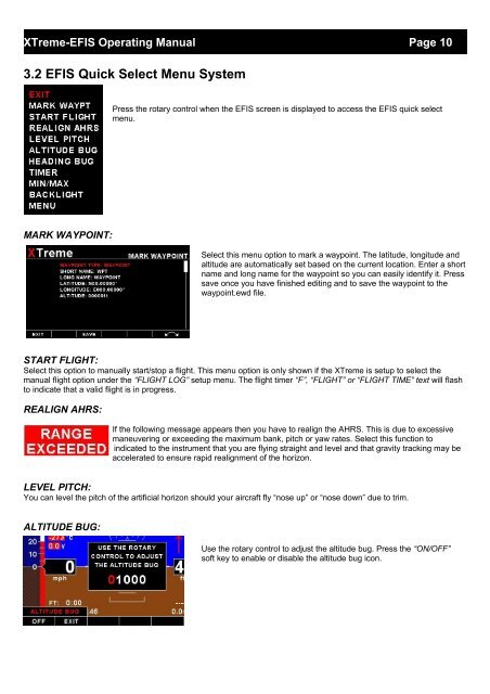
<strong>XTreme</strong>-<strong>EFIS</strong> Operating Manual Page 103.2 <strong>EFIS</strong> Quick Select Menu SystemPress the rotary control when the <strong>EFIS</strong> screen is displayed to access the <strong>EFIS</strong> quick selectmenu.MARK WAYPOINT:Select this menu option to mark a waypoint. The latitude, longitude andaltitude are automatically set based on the current location. Enter a shortname and long name for the waypoint so you can easily identify it. Presssave once you have finished editing and to save the waypoint to thewaypoint.ewd file.START FLIGHT:Select this option to manually start/stop a flight. This menu option is only shown if the <strong>XTreme</strong> is setup to select themanual flight option under the “FLIGHT LOG” setup menu. The flight timer “F”, “FLIGHT” or “FLIGHT TIME” text will flashto indicate that a valid flight is in progress.REALIGN AHRS:If the following message appears then you have to realign the AHRS. This is due to excessivemaneuvering or exceeding the maximum bank, pitch or yaw rates. Select this function toindicated to the instrument that you are flying straight and level and that gravity tracking may beaccelerated to ensure rapid realignment of the horizon.LEVEL PITCH:You can level the pitch of the artificial horizon should your aircraft fly “nose up” or “nose down” due to trim.ALTITUDE BUG:Use the rotary control to adjust the altitude bug. Press the “ON/OFF”soft key to enable or disable the altitude bug icon.