XTreme EFIS - STRATOMASTER Instrumentation MGL Avionics
XTreme EFIS - STRATOMASTER Instrumentation MGL Avionics
XTreme EFIS - STRATOMASTER Instrumentation MGL Avionics
- No tags were found...

You also want an ePaper? Increase the reach of your titles
YUMPU automatically turns print PDFs into web optimized ePapers that Google loves.
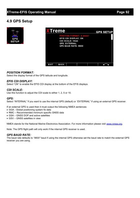
<strong>XTreme</strong>-<strong>EFIS</strong> Operating Manual Page 924.9 GPS SetupPOSITION FORMAT:Select the display format of the GPS latitude and longitude.<strong>EFIS</strong> CDI DISPLAY:Select “ON” to enable the <strong>EFIS</strong> CDI display at the bottom of the <strong>EFIS</strong> displays.CDI SCALE:Use this function to adjust the CDI scale to either 1, 2, 5 or 10.GPS:Select “INTERNAL” if you want to use the internal GPS (default) or “EXTERNAL” if using an external GPS receiver.If an external GPS is used then it must output the following NMEA sentences• GGA - Global positioning system fix data• RMC – Recommended minimum specific GNSS data• GSA – GNSS DOP and active satellites• GSV – GNSS satellites in viewNMEA stands for the National Marine Electronics Association. For more information please visit www.nmea.org.Note: The GPS flight path will only work if the internal GPS receiver is used.GPS BAUD RATE:The baud rate defaults to “9600” baud if using the internal GPS otherwise set the baud rate to match the external GPSreceiver you are using.