- Page 3 and 4:
Governor’s Commissionon Recovery,
- Page 5 and 6:
THE GOVERNOR’S COMMISSION REPORT
- Page 7 and 8:
THE GOVERNOR’S COMMISSION REPORT
- Page 9 and 10:
THE GOVERNOR’S COMMISSION REPORT
- Page 11 and 12: THE GOVERNOR’S COMMISSION REPORT
- Page 13 and 14: THE GOVERNOR’S COMMISSION REPORT
- Page 15 and 16: THE GOVERNOR’S COMMISSION REPORT
- Page 17 and 18: THE GOVERNOR’S COMMISSION REPORT
- Page 19: INFRASTRUCTUREThe four subcommittee
- Page 22 and 23: 12 | LAND USE■ City land use plan
- Page 24 and 25: 14 | LAND USEgional level, coastal
- Page 26 and 27: 16 | LAND USElored for South Missis
- Page 28 and 29: 18 | LAND USEThe qualityof life and
- Page 30 and 31: 20 | LAND USEand building requireme
- Page 32 and 33: 22 | LAND USEThroughout the Renewal
- Page 34 and 35: 24 | LAND USEapproval process for c
- Page 36 and 37: 26 | INTERMODAL TRANSPORTATIONINTER
- Page 38 and 39: 28 | INTERMODAL TRANSPORTATIONson C
- Page 40 and 41: 30 | INTERMODAL TRANSPORTATIONOn pu
- Page 42 and 43: 32 | INTERMODAL TRANSPORTATIONOn th
- Page 44 and 45: 34 | INTERMODAL TRANSPORTATIONOn th
- Page 46 and 47: 36 | PUBLIC SERVICESPUBLICSERVICESK
- Page 48 and 49: 38 | PUBLIC SERVICEStic tank use; a
- Page 50 and 51: 40 | PUBLIC SERVICESsources. The go
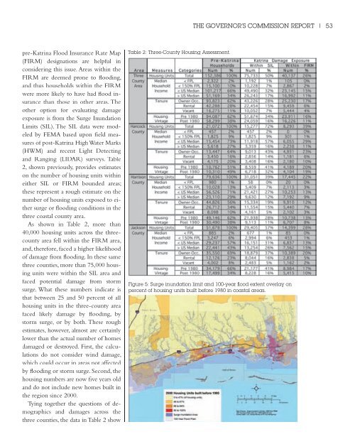
- Page 52 and 53: 42 | PUBLIC SERVICESBefore Katrinan
- Page 54 and 55: 44 | PUBLIC SERVICEScoverage capabi
- Page 56 and 57: 46 | PUBLIC SERVICESThe methods by
- Page 58 and 59: 48 | AFFORDABLE HOUSINGAFORDABLEHOU
- Page 60 and 61: 50 | AFFORDABLE HOUSINGTable 1, bel
- Page 64 and 65: 54 | AFFORDABLE HOUSINGthat about 6
- Page 66 and 67: 56 | AFFORDABLE HOUSINGbe helpful.
- Page 68 and 69: 58 | AFFORDABLE HOUSING[I]t would a
- Page 70 and 71: 60 | AFFORDABLE HOUSINGcities or co
- Page 72 and 73: 62 | AFFORDABLE HOUSINGand heavy tr
- Page 74 and 75: 64 | AFFORDABLE HOUSINGInvestment A
- Page 76 and 77: 66 | AFFORDABLE HOUSINGmendations i
- Page 78 and 79: 68 | AFFORDABLE HOUSINGadvice on th
- Page 80 and 81: 70 | AFFORDABLE HOUSINGAs insurance
- Page 82 and 83: 72 | AFFORDABLE HOUSINGRecommendati
- Page 85 and 86: THE GOVERNOR’S COMMISSION REPORT
- Page 87 and 88: ECONOMICDEVELOPMENTIn this section
- Page 89 and 90: THE GOVERNOR’S COMMISSION REPORT
- Page 91 and 92: THE GOVERNOR’S COMMISSION REPORT
- Page 93 and 94: THE GOVERNOR’S COMMISSION REPORT
- Page 95 and 96: THE GOVERNOR’S COMMISSION REPORT
- Page 97 and 98: THE GOVERNOR’S COMMISSION REPORT
- Page 99 and 100: THE GOVERNOR’S COMMISSION REPORT
- Page 101 and 102: THE GOVERNOR’S COMMISSION REPORT
- Page 103 and 104: THE GOVERNOR’S COMMISSION REPORT
- Page 105 and 106: THE GOVERNOR’S COMMISSION REPORT
- Page 107 and 108: THE GOVERNOR’S COMMISSION REPORT
- Page 109 and 110: THE GOVERNOR’S COMMISSION REPORT
- Page 111 and 112: THE GOVERNOR’S COMMISSION REPORT
- Page 113 and 114:
THE GOVERNOR’S COMMISSION REPORT
- Page 115 and 116:
THE GOVERNOR’S COMMISSION REPORT
- Page 117 and 118:
THE GOVERNOR’S COMMISSION REPORT
- Page 119 and 120:
THE GOVERNOR’S COMMISSION REPORT
- Page 121 and 122:
THE GOVERNOR’S COMMISSION REPORT
- Page 123 and 124:
THE GOVERNOR’S COMMISSION REPORT
- Page 125 and 126:
THE GOVERNOR’S COMMISSION REPORT
- Page 127 and 128:
THE GOVERNOR’S COMMISSION REPORT
- Page 129 and 130:
THE GOVERNOR’S COMMISSION REPORT
- Page 131 and 132:
HUMANSERVICESThe reports that follo
- Page 133 and 134:
THE GOVERNOR’S COMMISSION REPORT
- Page 135 and 136:
THE GOVERNOR’S COMMISSION REPORT
- Page 137 and 138:
THE GOVERNOR’S COMMISSION REPORT
- Page 139 and 140:
THE GOVERNOR’S COMMISSION REPORT
- Page 141 and 142:
THE GOVERNOR’S COMMISSION REPORT
- Page 143 and 144:
THE GOVERNOR’S COMMISSION REPORT
- Page 145 and 146:
THE GOVERNOR’S COMMISSION REPORT
- Page 147 and 148:
THE GOVERNOR’S COMMISSION REPORT
- Page 149 and 150:
THE GOVERNOR’S COMMISSION REPORT
- Page 151 and 152:
SPECIALREPORTSWhere do we go from h
- Page 153 and 154:
THE GOVERNOR’S COMMISSION REPORT
- Page 155 and 156:
THE GOVERNOR’S COMMISSION REPORT
- Page 157 and 158:
THE GOVERNOR’S COMMISSION REPORT
- Page 159 and 160:
THE GOVERNOR’S COMMISSION REPORT
- Page 161 and 162:
THE GOVERNOR’S COMMISSION REPORT
- Page 163 and 164:
THE GOVERNOR’S COMMISSION REPORT
- Page 165 and 166:
THE GOVERNOR’S COMMISSION REPORT
- Page 167 and 168:
THE GOVERNOR’S COMMISSION REPORT
- Page 169 and 170:
THE GOVERNOR’S COMMISSION REPORT
- Page 171 and 172:
THE GOVERNOR’S COMMISSION REPORT
- Page 173 and 174:
THE GOVERNOR’S COMMISSION REPORT
- Page 175 and 176:
THE GOVERNOR’S COMMISSION REPORT
- Page 177 and 178:
THE GOVERNOR’S COMMISSION REPORT
- Page 179 and 180:
THE GOVERNOR’S COMMISSION REPORT
- Page 181 and 182:
THE GOVERNOR’S COMMISSION REPORT
- Page 183 and 184:
THE GOVERNOR’S COMMISSION REPORT
- Page 185 and 186:
THE GOVERNOR’S COMMISSION REPORT
- Page 187 and 188:
THE GOVERNOR’S COMMISSION REPORT