

Bulletin 51, New Jersey Geodetic Control Survey Bench Marks in ...
Bulletin 51, New Jersey Geodetic Control Survey Bench Marks in ...
Bulletin 51, New Jersey Geodetic Control Survey Bench Marks in ...

Create successful ePaper yourself
Turn your PDF publications into a flip-book with our unique Google optimized e-Paper software.
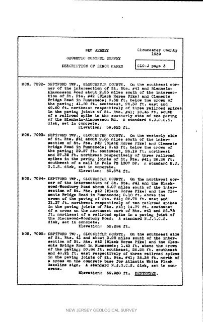
N_: JERSEY Gloucester Count_19_9G_ODR_IC COnTrOLS_RV_!D2SCR_IONOF_2Nc_ARK2 _G_oJp_s83IIJMON. ?092- DEPTFORD qMP., GLOUCiSTXR COUNTY. 0_ the southeast cornerof the <strong>in</strong>tersection of St, Rte. _41 and Blenhe_m-Almonesson Road about _._5 mllos south Of the <strong>in</strong>tersectlenof St, Rte. #42 {Blaek Horse Pike) and Cle_onteBrldgo Reed <strong>in</strong> R_nnemedo; 0.58 ft. below the crown ofthe pawln_; 41._ ft. southeast, 25.50 ft. east and42.60 ft. northeast respoctlvoly of three railroad splke_<strong>in</strong> the pavln_ Jo<strong>in</strong>to of St, _te° #41; 12°45 ft, southOf a rall_oed spike <strong>in</strong> the southerly Bide of the pavln_of the Blonhelm-Almonesson Rd. A standmrd N.J.G,C.S.disk a set In _onerete.Elevatlon: 59.653 ft.MON° 7093- DEPTFOND TWp,, GLOUCESTER COUNTY. On the westerly si_oof St. Rto, #41 abbot _._ miles South of the In_ersectionof St, Rio. #42 (Black Horse Pike) and Clements_rld_e Road <strong>in</strong> Runnomedo; 0._ ft, below the crown ofthe pavln_; 29,57 ft. southwest, 25.19 ft. northwestand _?.Sa £t, northwest respectlvoly of three railroadspikes <strong>in</strong> the pav_ Jo<strong>in</strong>ts of St. to, #41; 26.26 ft.Southwest of a nell <strong>in</strong> Polo PS I_OV DP. A standard N.J.G.C.S. disk, set <strong>in</strong> ooncrete.Elevation: 60°5?4 ft.MON. V094- DEPTFORD TWP., GLOUCESTER COU_T_. On the northwest oorne_O_ the <strong>in</strong>tersection of St. Rto+ _41 and the Blaekwoed-Woodbur7Hoad about _°07 miles south of the <strong>in</strong>te_-se_ti_ of St, Rio. f42 (21a_k Horse Pike) and the ClemonteBridge Road <strong>in</strong> E_ulnemedo_ 0.18 Pt, above theO_c_n of the pav_ of Rt_. _41; 28.7_ ft_ WOSt_I,_7 ft. northwest respectivel_ of two railroad opikos<strong>in</strong> the pav<strong>in</strong> 6 jo<strong>in</strong>ts of _ts. _41; 14o77 _t. southwesto£ a cross on the northwest curb of Rte, f41 and 26,78ft. northeast of a railroad spike <strong>in</strong> a pav_ Jo<strong>in</strong>_ ofthe Rlackwo_-Woo_bu_ ROad, A ate_dar_ N.J.G.C,S.dlek_ set <strong>in</strong> concrete.Elevation: 5S,284 ft.MO_. V095- DEPTFO_D _p°, GLOUCESTER COUNTY. On the southeast side_f St. Rto. 41 and about 3.28 mllol south o_ the <strong>in</strong>ter_section of _t. Rio. f4_ (Rlook Horse Pike) and the Cle_-onts Brld_e Road <strong>in</strong> Runnomede; 1,4_ ft. abovo the crownof the pav_6; _0.84 ft. southeast, 26.28 ft. _outheastand 40.21 ft. east rospsctivol7 of three _allroed eplke_<strong>in</strong> the pavln_ Jolnto of _t. Rte. _41; 35.38 ft. north of• _ross c_ the concrete base for Atlantic White FlashGasol<strong>in</strong>e sign, A mta_ar_ N.J,G.C.So disk_ sot <strong>in</strong> o_-OP_te •_ev&tlo_l _9.P60 ft. DESTROYED,NEW JERSEY GEOLOGICAL SURVEY


