

Bulletin 51, New Jersey Geodetic Control Survey Bench Marks in ...
Bulletin 51, New Jersey Geodetic Control Survey Bench Marks in ...
Bulletin 51, New Jersey Geodetic Control Survey Bench Marks in ...

You also want an ePaper? Increase the reach of your titles
YUMPU automatically turns print PDFs into web optimized ePapers that Google loves.
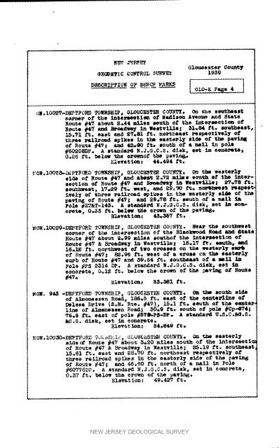
NE_, JEP_.EYOlouoesteeeECiDETIC COF'_ROL S'OlWE2 193_CountTD_S:RZ,PT_O_N OF B_t_d'_ .ARKS |[ GLO-K Pa_e 4 1Iomxm,ee of the lntermeotlma of ladimon Averme and St;a_eRoute #47 about g_44 _LIoe mouth st the <strong>in</strong>_ermeotlou ofRoute #4"/ a_ _oud_ _n Weetvllle; _1.84 ft. mo_theomt_.71 ft, east and 97.81 g_. northeast z_a_o¢ivel 7 of_h_ee 3_LAI_d spikes <strong>in</strong> thJ easterly eE_ of tl_ pav_o£ Route #47| and 42_90 tee south of • nail <strong>in</strong> pole#60_OaDp. A mtanda1_ _;.J.G,C._. disk, set _ eOU@I_Y_0.26 ft. below the Ol'ow_of the pevln_Elevat io_ _ 44.494 ft,.',TO_.IO_8-_PTFORD TO_SHIP_ OLOUCF_T_ COU_Iw£. On the wes_eF'17eldm o£ Route #4='/ and ab_m_ 2o?2 miles south of the <strong>in</strong>tereeot2on o_ l_oute #47 and Bt_ac1_a 7 <strong>in</strong> _eeb'_tlle; _'r.';'8 1"_.eouth_, 1V_29 _ WeSt, and 2_,90 f_. no_h_esl_ _a_ee_i_el_ of _h_'ee roLl.sad spikes _n the weeterl_ sl_ of thepav<strong>in</strong> 6 o_ Route #47; a_d 89.78 f_. south oA" • na_l _apOI"#_&T-14_. A 8ta_d_ N.J.O.C.$. disk_ set A_ eo_-stets, 0.._3 f_;, Mele_ _e crown Of the pavl=q_.Elevat iou: 43.,35'/f_.MOK.IOOgE-DEP-TFORD TO_J_ZP, GLOUOESTE_ COU_T_. Nea_cozener o_ the <strong>in</strong>_eP_eetlon o1" the Blaokwoodthe eou_weet_Oe.d _ _l;ateHoute #47 a_eu_ ?..99 m11_e so.thor the Inte_eetl_n efRoute #4716,,Io ft.& B_oadwa_ <strong>in</strong> _eetville__o_h_eet of two Orosse=lfl.17 f'r, =lm_t_h_on _ _eteFl_ e_o£ Route #47; 8_.96 ,P_+,, west of a e_s ca _ e_t_='2yeu4.b of Route #47 and 39,64 ft. s_r_eut of a mail <strong>in</strong>Pole #P_ _314 Dp. A s_n_ard N.J.G.C,S. _ek, ee_ <strong>in</strong>concrete, 0,12 ft. below _he el-sen of the _v_6 Of RouteElevat IOU# E_oMI ft.MON. 843 -DEPTFORD TOWNShIp, GLOUC_TE_ COU}_. _ t_e _u_h eldeof Almonessen Roa_ m 186+5 ft. east of the een_e_<strong>in</strong>e 01"Delsea D_Ive (E.H. R_e. #4V), 15.1 ft. south of the eenter,ltue of Almeneeeen Road; 30.9 ft* south ef pole #0p-674#76.6 ft. eae_ Of pole #EY_-ps*DP. A standard U._,Co_.S./_,S. disk, ee_ <strong>in</strong> eono%_ete.Eleva_ _on: 64.849 re._ON.IOO_O-DE_TFORD T_L_SI_IF_ GLOUC_ET_ COYT_"/a n_ t_ east_l_s_de_ Route #47 about _..20 m_les south of the <strong>in</strong>tereeoti_of Route #47 & Broad_a_ <strong>in</strong> Wes_llle; _5.19 f_. eoutJ_east15,61 f_. east end 28,70 ft. northeast _eepeetlvel 7 oft;h.ree _allr_ad spikes <strong>in</strong> _he easterl7 side of the pa_ln_of Route #47; _nd 46.S0 ft. north of a n_Ll <strong>in</strong> Pole#_0776DPo A e_ands_d NoJ.G.C.S* disk. se_ <strong>in</strong> ¢_¢J_ete_0.57 ft. below _he cro,m of _he pav_.Elevation: 49.42? ft.NEW JERSEY GEOLOGICAL SURVEY


