

Bulletin 51, New Jersey Geodetic Control Survey Bench Marks in ...
Bulletin 51, New Jersey Geodetic Control Survey Bench Marks in ...
Bulletin 51, New Jersey Geodetic Control Survey Bench Marks in ...

You also want an ePaper? Increase the reach of your titles
YUMPU automatically turns print PDFs into web optimized ePapers that Google loves.
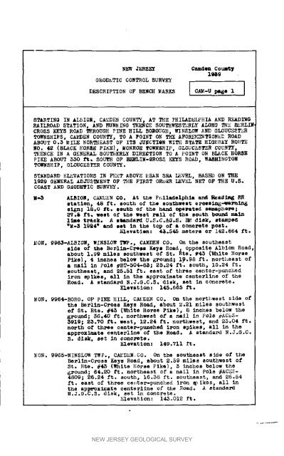
NEIN _RS_ Camden Coul_"tffi_, 9GEODETIC CONTROL SURVEYDESCRIPTION OF BENCH _ARKS I CA_-U pe6e I ISTARTINQ IN ALBION, CAMDEN COUNTY, AT THE PHILADELPHIA AND READI_ORAILROAD STATION, AND RUNNINO T_CE SOUTHT_E3_RLY ALONG TH_ _RLIN_CRO_S KEYS ROAD THROUGH PINE HILL BOROUQII, _qN_LOW AND GLOUC_RTO.SHIPS, CAMDEN COUNTY, TO A POINT ON THE AFOR_TION_ ROADABOUT 0.5 MILE NO_EAST OF ITS /dNCTXeN WI_I STATE HIGII_AY ROtaTENO. 42 (BLACK _ORqE PIKE), M_ROE TO_8_IP, GLOUCESTER COUNTY,THENCE IN A GENERAL SOU_iERLY D_RE_TION TO A POINT ON BLACK HORSEPIKE ABOUT 550 f_° SOUTH OP _LIN-_ROS_ _S ROAD, WASHINGTONTO.SHIP, GI_UCESTE_R COUNTY.STANDARD _L_ATIONS I_ FEET ABOVE MEAN S_A LEVEL, BASS_ ON THE1929 GENERAL ADJUSTMENT OF THE FIRST ORDER LEVEL NET OF THE U_S.COAST AND GSODETIC SURVEY._-5 ALBIOn, CAMDEN CO. At t_o P_l_e_hl_ _ Read_ RRetatlonh 48 ft. south of the sou_hwe_ eroes<strong>in</strong>s-4ea_n_s_n_ 18.0 _t. south of the hen_ operated semaphore;_.$ ft_ _est o_ the west l_all o_ the sou_h bo_ ma<strong>in</strong>ll_e t_a_k. A a_da_ U.S.Co_G.S. _' disM. _tampe_aM-_ 19_4" _nd _et <strong>in</strong> the top of • oono_ete post._levatien: 4_4.5 meterB or 142.864 ft.MON. 9_-ALBION_ W_NSLO_ T_P°, CAEE_N CO. On the southeastside of _he _l<strong>in</strong>-C_s Ee_a Ro_d, oppoBite Albion Ro_,about 1.99 miles southwest of St. Rte. _4_ (_hite Horsepike), 4 lnchea below the _ound; 19o98 ft. nor_]_east ofa n_l In _ole _BT-50_-8_; 2S.24 St. south, 15.24 ft.southeast, emd _5.<strong>51</strong> f_. east of three conter-punchediron sp_kes, all <strong>in</strong> the approximate eenterl<strong>in</strong>e of theRoa_. A stan_aPd _.J.G.C.S. _isk, Set <strong>in</strong> concrete.Elevation: 145.665 _.MON. 9964-BORO. OP PINE HILL_ C_D_N CO. On the northwest si_e ofthe Berl<strong>in</strong>-Croas Keys Road, about 2.21 miles southwestof St. Rte. #45 (_hite Ho_se Pike), 8 <strong>in</strong>ches below _he8_ound_ 36.40 _¢. nor_hwes_ of a nail An _ole _C_-3919; 2_._0 £t_ wes_, 12.24 ft. northwest, and 2_.04 ft.north o_ three center-punehed _on spikes, all <strong>in</strong> theapproximate centert<strong>in</strong>e of _he ROad. A standard N.J.G.C.S. dls_, _e_ <strong>in</strong> concl_s_e°Elev_tion: 149.Vll _t.MON. 9965-WINSLOW T_P., C_I_D_N CO. On the southeaat s_de of _he_l<strong>in</strong>-C_oso Keys Road, _bou_ 2.$9 m_les southwest ofSt. R_e. #45 (White Horse P_ke), 5 <strong>in</strong>ches below the6round; 6_.20 ft. northeast of a nail <strong>in</strong> Pole #ACE_-4809; 26._4 f_° sou_h_ 16.$8 ft. sou%beast, and 26.$4ft. east of three ce_Jter-punched _ron _ ikes, all <strong>in</strong>the apI_Ximat_ cen_e_l_ne of the Road. A _tan_az_N.J.G.C.S. dick, s_t _n conor_e.Elevation: 14_.01_ _t.NEW JERSEY GEOLOGICAL SURVEY


